Real-time street view navigation method and device

A navigation method and street view technology, applied in the field of navigation, can solve the problem of map data occupying storage space of navigation products, etc., and achieve the effect of reducing the demand for storage space

Active Publication Date: 2011-07-13
北京四维智联科技有限公司
View PDF4 Cites 35 Cited by
  • Summary
  • Abstract
  • Description
  • Claims
  • Application Information

AI Technical Summary

Problems solved by technology

Moreover, whether the map data is pre-stored in the navigation product, or the navigation product obtains the map data from t...

Method used


Image

  • Real-time street view navigation method and device
  • Real-time street view navigation method and device
  • Real-time street view navigation method and device

Examples


Embodiment Construction

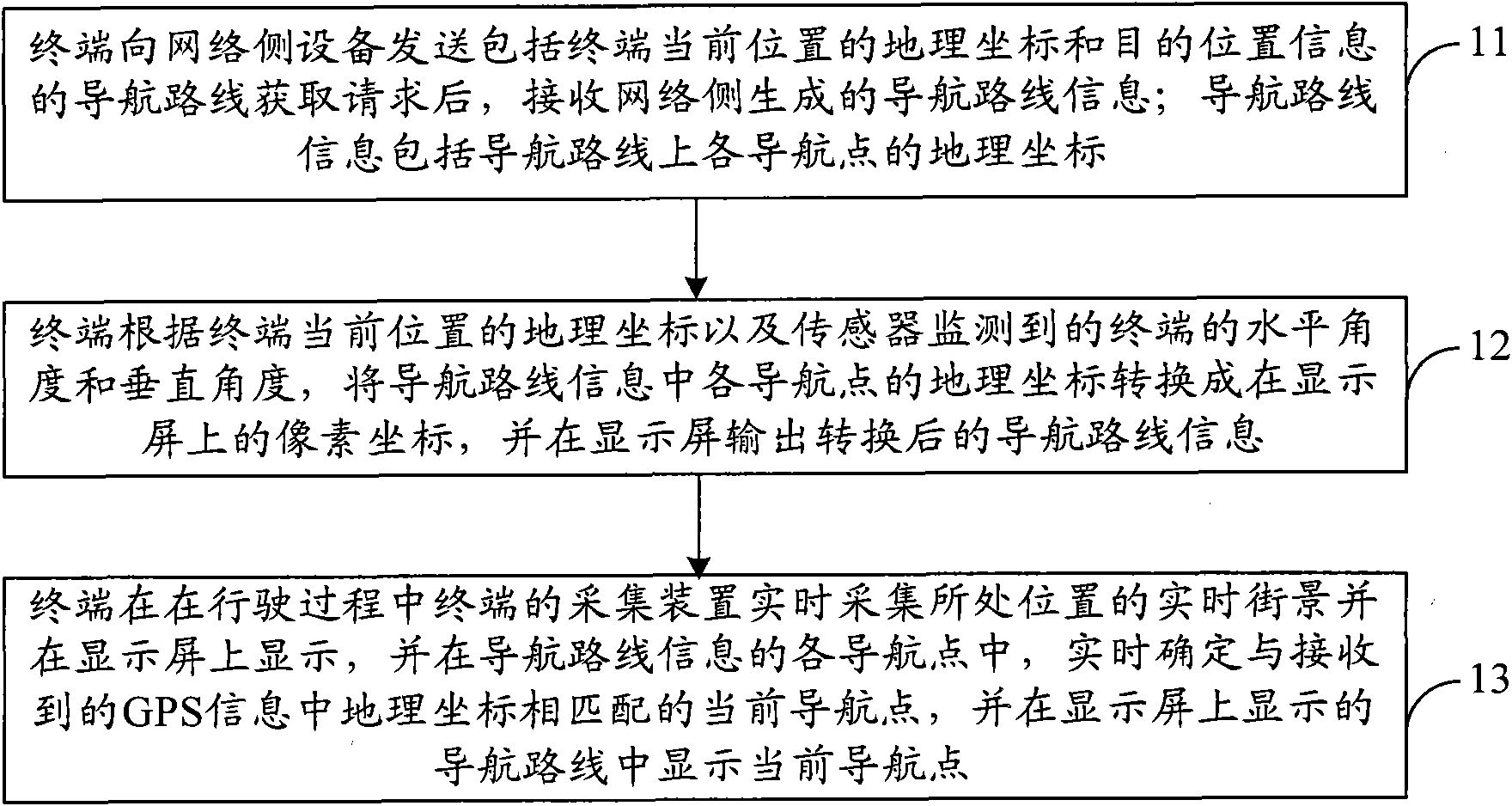
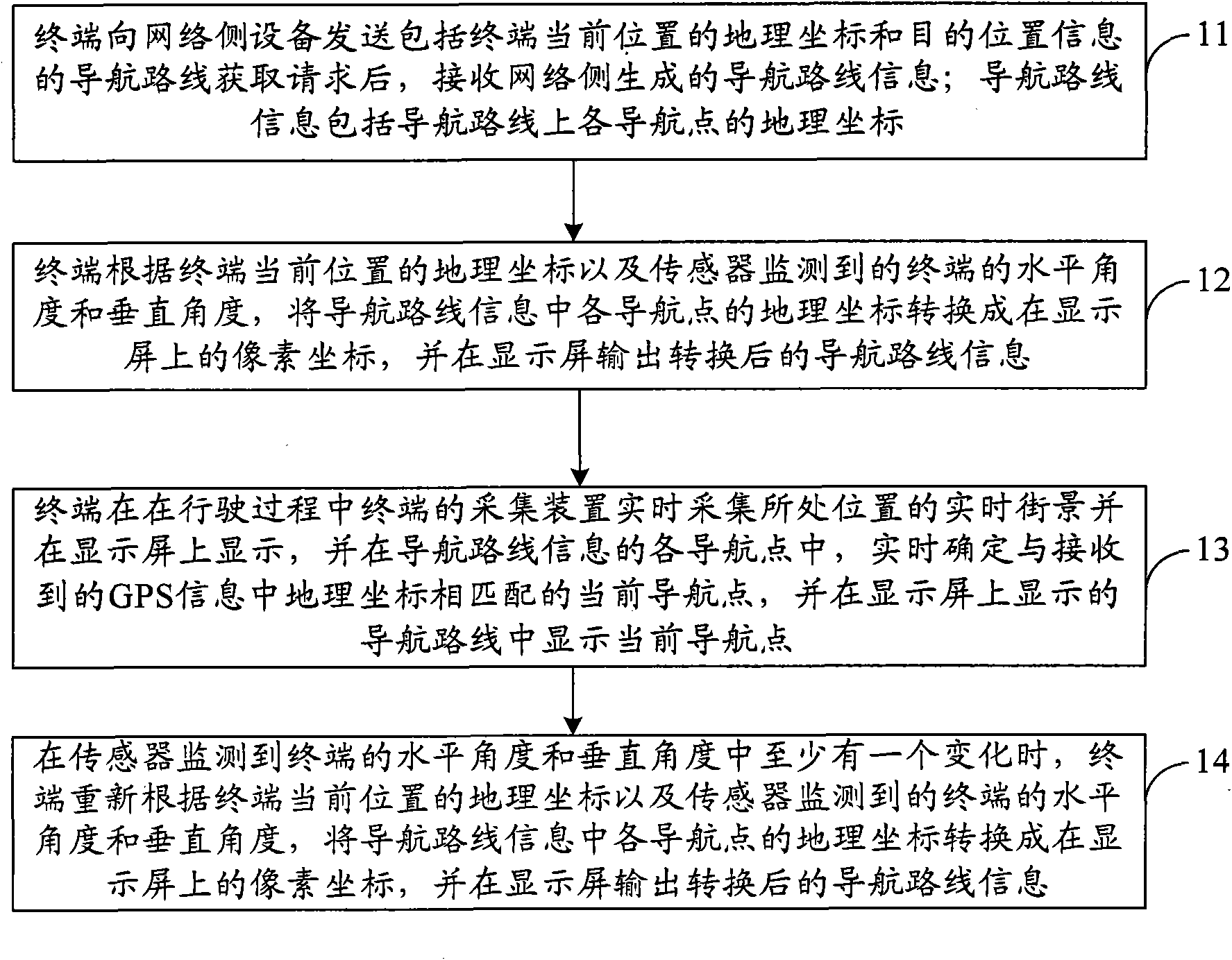
[0030] In order to make the purpose, technical solutions and advantages of the embodiments of the present invention clearer, the technical solutions in the embodiments of the present invention will be clearly and completely described below in conjunction with the drawings in the embodiments of the present invention. Obviously, the described embodiments It is a part of embodiments of the present invention, but not all embodiments. Based on the embodiments of the present invention, all other embodiments obtained by persons of ordinary skill in the art without making creative efforts belong to the protection scope of the present invention.

[0031] The terminal of the present invention acquires the navigation route from the current position to the target position in real time from the network side equipment (the current position of the terminal can be obtained through the GPS module installed on the terminal), and then combines the position parameters of the terminal to draw the n...


PUM


Abstract

The invention provides a real-time street view navigation method and device. The method comprises the following steps of: sending a navigation route acquisition request including a geographic coordinate of a current position of a terminal and positional information of a destination to a network-side device, and receiving navigation route information generated by a network side; determining the geographic coordinate of the current position of the terminal through GPS (Global Positioning System) information received by the terminal at the current position; transforming the geographic coordinates of all navigation points in the navigation route information into pixel coordinates on a display screen according to the geographic coordinate of the current position of the terminal and a horizontal angle and a vertical angle which are monitored by a sensor of the terminal, and displaying the transformed navigation route information on the display screen of the terminal; and collecting real-time street view of the position at which the terminal is located by an acquisition unit of the terminal in real time during driving and displaying the street view on the display screen, determining the current navigation point matched with the geographic coordinate in the received GPS information in real time from the all navigation points of the navigation route information, and displaying the current navigation point in a displayed navigation route on the display screen.

Description

technical field [0001] The invention relates to navigation technology, in particular to a real-time street view navigation method and device. Background technique [0002] Current navigation products, such as mobile phones, personal digital assistants, and car navigators with GPS (Global Positioning System) modules, when performing real-time navigation, first locate the current position according to the GPS signal received by the GPS module latitude and longitude information. Then, combine the longitude and latitude information with the electronic map, and mark the current relative position information on the electronic map. Afterwards, according to the destination location input by the user and the current location information, the navigation route from the current location to the destination location is calculated, and the navigation route is displayed on the electronic map. During the driving process, the analog points displayed on the electronic map follow the terminal...

Claims


Application Information

Patent Timeline
IPC IPC(8): G01C21/34G01C21/28
Inventor 王庚
Owner 北京四维智联科技有限公司
Why Eureka
Try Eureka