Adaptive scale DEM (digital elevation model) modeling method capable of keeping terrain features

A technology of terrain features and modeling methods, applied in 3D modeling, instrumentation, calculation, etc., can solve the problems of data redundancy, inconsistency, and inability to meet the actual scale requirements, and achieve the solution of data redundancy and watershed line simplification. Effect

Inactive Publication Date: 2012-07-04
WUHAN UNIV +1
View PDF3 Cites 0 Cited by
  • Summary
  • Abstract
  • Description
  • Claims
  • Application Information

AI Technical Summary

Problems solved by technology

[0029] What the present invention is to solve is the data redundancy, inconsistency, inability to meet the actual scale requirements and the inability to maintain basic

Method used


Image

  • Adaptive scale DEM (digital elevation model) modeling method capable of keeping terrain features
  • Adaptive scale DEM (digital elevation model) modeling method capable of keeping terrain features
  • Adaptive scale DEM (digital elevation model) modeling method capable of keeping terrain features

Examples


Embodiment Construction

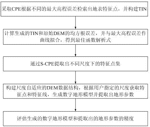
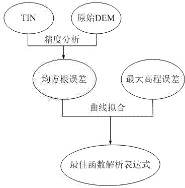
[0057] The core problem to be solved by the present invention is to construct a fine DEM database applicable from wide area to local range, extract multi-scale terrain parameters and features from the database according to application requirements, and maintain different levels of terrain features according to the scale information, This makes the terrain skeleton basically consistent at different scales. Theoretically, in order to perform multi-scale terrain analysis, the surface elevation dataset needs to meet three basic conditions:

[0058] 1. Use a fine-scale DEM database to represent data of any scale required.

[0059] 2. Terrain parameters (average slope, roughness) cannot change dramatically with the change of scale, and the basic characteristics of the terrain need to be maintained.

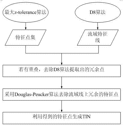
[0060] 3. The extracted watershed network, terrain elements, etc. cannot undergo drastic changes. That is, landform features, assembly lines, geometry and overall structure cannot und...


PUM


Abstract

The invention provides an adaptive scale DEM (digital elevation model) modeling method capable of keeping terrain features. A fine DEM database suitable for wide areas to local areas is built; an adaptive scale data structure and an analysis method are put forward; multi-scale terrain parameters and features are extracted from the fine-scale DEM database according to the application requirements;according to the scale information, different grades of terrain features are kept; and terrain skeletons are almost same under different scales. With the method, the adaptive scale technology is applied to the field of digital terrain analysis, the multi-scale DEM generation efficiency is improved, and the terrain characteristic consistency is guaranteed, and the requirements on the scale in the practical application are satisfied.

Description

technical field [0001] The invention belongs to the field of digital terrain analysis, in particular to an adaptive scale DEM modeling method for maintaining terrain features. Background technique [0002] Digital elevation model (Digital Elevation Model, DEM) is used to express the terrain and landform features in the natural environment, and it is an important part of the spatial data infrastructure. With the release of the global SRTM (Space Shuttle Radar Topographic Mapping Mission) 90-meter resolution DEM database and the ASTER GDEM (Advanced Spaceborne Thermal Emission and Reflection Radiometer Global Digital Elevation Model) 30-meter resolution DEM database, the nationwide1: The establishment of 1 million, 1:250,000, and 1:50,000 DEM databases and the construction of regional 1:10,000 DEM databases have been completed successively. The DEM database presents the characteristics of multi-scale, multi-resolution, and multi-data sources. [0003] The scale effect of spat...

Claims


Application Information

Patent Timeline
IPC IPC(8): G06T17/05
Inventor 陈玉敏周启鸣朱全生祁昆仑
Owner WUHAN UNIV
Why Eureka
Try Eureka