Method for extracting land for teaching by using remote sensing image, relative elevation and geographic ontology

A technology of remote sensing images and geographic ontology, applied in the field of spatial information, can solve problems such as the inability to extract teaching land, achieve the effects of saving time and manpower, high precision, and broadening thinking

Inactive Publication Date: 2011-09-21
WUHAN UNIV OF TECH
View PDF3 Cites 38 Cited by
  • Summary
  • Abstract
  • Description
  • Claims
  • Application Information

AI Technical Summary

Problems solved by technology

However, teaching land is mostly composed of teaching buildings, dormitory buildings, etc., and there is no essential difference in remote sensing charact

Method used


Image

  • Method for extracting land for teaching by using remote sensing image, relative elevation and geographic ontology
  • Method for extracting land for teaching by using remote sensing image, relative elevation and geographic ontology
  • Method for extracting land for teaching by using remote sensing image, relative elevation and geographic ontology

Examples


Embodiment Construction

[0023] Embodiments of the present invention will now be described with reference to the drawings, in which like reference numerals represent like elements.

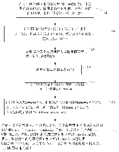
[0024] refer to figure 1 , the present embodiment uses remote sensing imagery, relative elevation and geographic ontology to extract the method for teaching land, comprising the following steps:

[0025] Step S1, use the rules to extract shadows from the vector map of the remote sensing image of the preset location (the preset location can be Hangzhou City, and use Yikang software to automatically segment the remote sensing image of the preset location-Hangzhou City, and the Hangzhou City can be obtained. The vector map of the remote sensing image; because the remote sensing image contains complex land types, the vector map obtained by automatically segmenting the remote sensing image indicates that the land type is also more complex, which can be roughly divided into shadows and buildings (buildings include two parts: ro...


PUM

PropertyMeasurementUnit
Areaaaaaaaaaaa

Abstract

The invention provides a method for extracting land for teaching by using remote sensing image, relative elevation and geographic ontology, which comprises the following steps of: extracting a shade, a roof and a playground from a vectorgraph of a remote sensing image on a preset district; calculating the area of the extracted shade, producing a bounding rectangle on the shade, calculating the area, the perimeter, the length and the width of the bounding rectangle and determining the height of a building according to the ratio of the area of the shade to the area of the bounding rectangle; converting the height of the building into floor number in terms that the height is 3.5 meters in each floor; calculating the area of the extracted roof; multiplying the area of the roof by the floor number to obtain the building area of each building; calculating the area of the extracted playground; acquiring the total building area of the school by using the area of the playground; and determining the range of the land for teaching by using spatial analysis according to the total building area of the school. By using the method, the remote sensing technology is successfully applied to the field of extraction of the land for teaching and can be used for extracting the land for teaching; in addition, the extracted information for the land for teaching is comprehensive and is convenient foraccurately classifying the land types.

Description

technical field [0001] The invention relates to the field of spatial information, in particular to a method for determining the range of teaching land by using the shadow of buildings in high-resolution remote sensing images and the playground, the symbol of the teaching land. Background technique [0002] With the increasing awareness of environmental protection, in urban planning and construction, some sensitive areas such as schools need to be planned and constructed in a targeted manner. When doing urban regional planning, it is necessary to understand the current situation of land use in the planning area before making a decision. Harmonious and scientific decision-making, otherwise, it is obviously inappropriate to plan an area with high school density as an industrial area. It is particularly important to automatically (or semi-automatically) extract the type of educational function land. However, the traditional method relies on manual surveys and paper maps, which ...

Claims


Application Information

Patent Timeline
IPC IPC(8): G06K9/52G06T7/00G01S17/89
Inventor 崔巍李荣李清清
Owner WUHAN UNIV OF TECH
Why Eureka
Try Eureka