
Multiple-antenna GPS(Global Positioning System)/GF-INS (Gyroscope-Free-Inertial Navigation System) depth combination attitude determining method

A GF-INS, multi-antenna technology, applied in satellite radio beacon positioning system, navigation through speed/acceleration measurement, radio wave measurement system, etc., can solve eclipse, research and application limitations, attitude angle calculation errors, etc. problem, to achieve the effect of overcoming the difficulty of installation, improving the anti-interference ability, and improving the search success rate

Inactive Publication Date: 2013-06-19
BEIHANG UNIV
View PDF3 Cites 1 Cited by
  • Summary
  • Abstract
  • Description
  • Claims
  • Application Information

AI Technical Summary

Problems solved by technology

When the GPS signal is good, this method can significantly improve the positioning and attitude determination accuracy of the entire system; when the GPS signal is weak, the success rate of the estimation of the GPS double-difference carrier phase integer cycle number cannot be guaranteed, and this method is eclipsed
[0010] In 2004, Zha Yue and others proposed to use information fusion technology (specifically applied as joint Kalman filter technology) to carry out information fusion of GPS and SINS (strapdown inertial navigation system), under the premise of high accuracy of GPS carrier phase observation , can improve the measurement accuracy of the attitude angle of the whole system, but when the accuracy of the GPS carrier phase observation is not high, the calculation of the attitude angle may cause incorrect results, which will not only affect the measurement accuracy of the attitude angle of the entire integrated navigation system, but also due to information fusion Afterwards, feedback correction is performed on SINS, therefore, it will also affect the navigation calculation of SINS at the next moment
[0011] In 2006, Lu Hongqian of Harbin Institute of Technology and others proposed a single-antenna / GPS combined attitude measurement method. This method has a simple structure and low cost, but the single-antenna attitude measurement can only give the situation of coordinated flight (that is, the sideslip angle is zero) The attitude of the carrier under the condition cannot provide real-time attitude information under any flight condition
The cost of the GF-INS system is lower than that of the traditional inertial navigation system. Due to the difficulty in installing and calibrating the accelerometer under the complex configuration scheme, the simple configuration scheme cannot fully provide the position, velocity and attitude angle information of the carrier, making the relevant GPS / The research and application of GF-INS integrated navigation system are limited

Method used


Image

  • Multiple-antenna GPS(Global Positioning System)/GF-INS (Gyroscope-Free-Inertial Navigation System) depth combination attitude determining method
  • Multiple-antenna GPS(Global Positioning System)/GF-INS (Gyroscope-Free-Inertial Navigation System) depth combination attitude determining method
  • Multiple-antenna GPS(Global Positioning System)/GF-INS (Gyroscope-Free-Inertial Navigation System) depth combination attitude determining method

Examples


Embodiment Construction

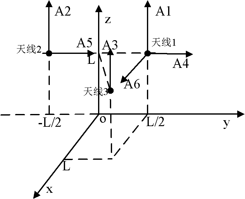
[0058] Such as figure 1 As shown, in the embodiment of the present invention, GF-INS adopts an easy-to-install accelerometer configuration scheme, which includes 6 accelerometers A1, A2, A3, A4, A5, A6; there are 3 GPS antennas: main antenna 1 , secondary antenna 2, 3,; accelerometers A1, A4, A6 are installed together with main antenna 1, A2 and A5 are installed together with secondary antenna 2, A3 is installed together with secondary antenna 3; accelerometers A1, A2, A3 The sensitive direction of A4 and A5 is along the positive direction of the z-axis of the carrier coordinate system, the sensitive direction of A4 and A5 is along the positive direction of the x-axis of the carrier coordinate system, and the sensitive direction of A6 is along the positive direction of the y-axis of the carrier coordinate system; the three antennas are respectively fixed on the three carrier Above; the base line formed by the carrier fixedly connected to the main antenna 1 and the auxiliary an...


PUM


Abstract

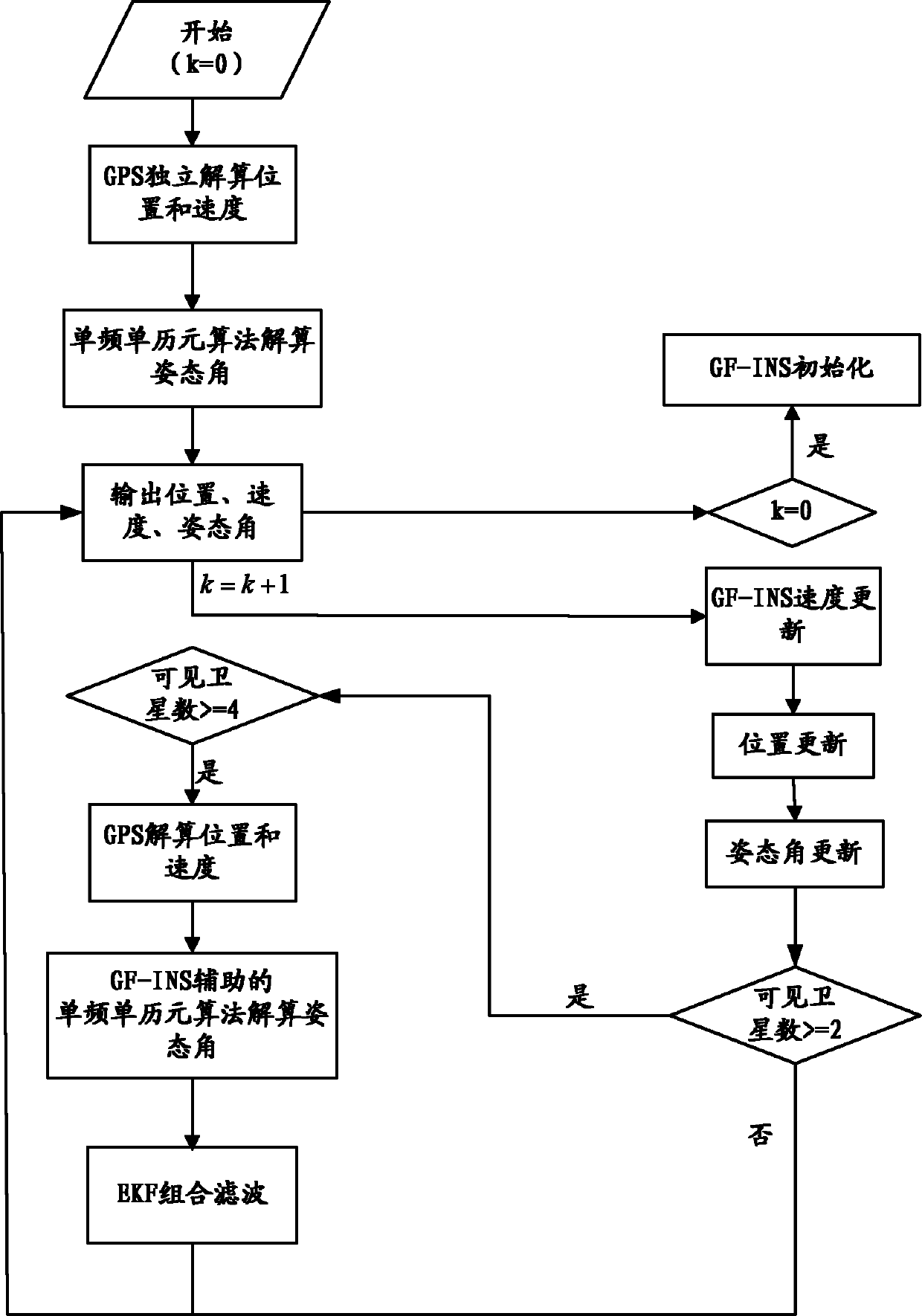
The invention discloses a multiple-antenna GPS(Global Positioning System) / GF-INS (Gyroscope-Free-Inertial Navigation System) depth combination attitude determining method. The method comprises the following steps: when a multiple-antenna GPS / GF-INS system operates for the first time, the GPS independently work to independently resolve position, speed and an attitude angle firstly; after the GPS stably works, the position, speed and attitude angle of the GF-INS are initialized according to the position, speed and a carrier attitude angle, which are output by the GPS; and after the GF-INS is initialized, navigation calculation is performed normally, wherein the multiple-antenna GPS / GF-INS system outputs the position, the speed and the attitude angle according tp a preset method. The multiple-antenna GPS / GF-INS depth combination attitude determining method has simple structure, and the search successful rate of a GPS double-difference complete-cycle ambiguity can be greatly improved so as to improve the attitude measurement precision of the GPS system and the navigation precision and the anti-jamming capability of the whole combined navigation system.

Description

technical field [0001] The invention relates to the field of combined navigation, positioning and attitude determination, in particular to a multi-antenna GPS / GF-INS deep combined attitude determination method. Background technique [0002] As small unmanned aerial vehicles, smart artillery shells, short-range missiles and other highly dynamic small weapons have continuously improved navigation performance requirements such as high precision, anti-jamming, high reliability and low cost, and so far, any single navigation system has This requirement cannot be fully met. Therefore, an integrated navigation system that can achieve complementary advantages and improve the accuracy, reliability and stability of the system has become a research hotspot in the field of navigation. [0003] Inertial Navigation System (INS) is a propulsion system that can work independently. The traditional inertial navigation system uses a gyroscope to sense the attitude angular velocity of the carr...

Claims


Application Information

Patent Timeline
Patent Type & Authority Patents(China)
IPC IPC(8): G01S19/47G01S19/49G01C21/16
Inventor 丛丽秦红磊张亚珍
Owner BEIHANG UNIV
Learn More