
Combination height control method and system for unmanned aerial vehicle

A technology of altitude control and drone, applied in the control/regulation system, vehicle position/route/altitude control, non-electric variable control and other directions to achieve the effect of precise drone altitude control

Inactive Publication Date: 2012-07-04
XIAN WIDE WORLD ZENITH AVIATION TECH
View PDF4 Cites 18 Cited by
  • Summary
  • Abstract
  • Description
  • Claims
  • Application Information

AI Technical Summary

Problems solved by technology

However, because the altitude of drones ranges from a few meters to thousands of meters, sometimes very accurate altitude values ​​are required, and existing altimeters cannot meet this requirement

Method used


Image

  • Combination height control method and system for unmanned aerial vehicle
  • Combination height control method and system for unmanned aerial vehicle

Examples


Embodiment Construction

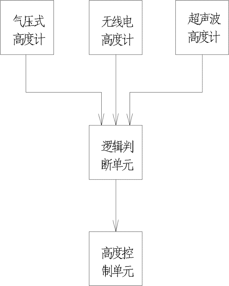
[0018] The combined height control system for unmanned use of the present invention comprises the barometric altimeter, radio altimeter and ultrasonic altimeter that are arranged on the unmanned aerial vehicle, and logical judging unit and altitude control unit, logical judging unit can be from barometric altimeter, radio altimeter and ultrasonic altimeter Select and calculate the output altitude value and output a selected or calculated control altitude value. After receiving the control altitude value, the altitude control unit uses this value as a height feedback signal for automatic control of the UAV.

[0019] The combined height control method for unmanned use of the present invention, the main steps are as follows:

[0020] 1) Obtain barometric altitude, radio altitude and ultrasonic altitude at the same time by means of air pressure measurement, radio measurement and ultrasonic measurement;

[0021] 2] Judging which of the three height values ​​or the average of the tw...


PUM


Abstract

The invention relates to a combination height control method and a system for an unmanned aerial vehicle. The combination height control system for the unmanned aerial vehicle comprises an air-pressure type height gauge, a wireless height gauge, an ultrasonic wave height gauge, a logical judgment unit and a height control unit, wherein the air-pressure type height gauge, the wireless height gauge and the ultrasonic wave height gauge are arranged on the unmanned aerial vehicle; the wireless height gauge selects, calculates and outputs output height values of the air-pressure type height gauge, the wireless height gauge and the ultrasonic wave height gauge; and the height control unit is used for automatically controlling the height of the unmanned aerial vehicle. The combination height control method and the system for the unmanned aerial vehicle solve the technical problem existing in the background technology and achieve accurate height control of the unmanned aerial vehicle.

Description

technical field [0001] The invention belongs to an unmanned aerial vehicle height control system. Background technique [0002] There are many kinds of altimeters, including barometric altimeters, laser altimeters, GPS altimeters, radar altimeters, radio altimeters, ultrasonic altimeters, etc. Each altimeter has different measurement ranges, application environments, and measurement errors. However, because the altitude of drones ranges from a few meters to thousands of meters, sometimes very accurate altitude values ​​are required, and existing altimeters cannot meet this requirement. Contents of the invention [0003] In order to solve the above-mentioned technical problems existing in the background technology, the present invention provides a combined height control method and system for unmanned aerial vehicles. [0004] Technical solution of the present invention is: [0005] A combined height control method for unmanned aerial vehicles, which is special in that it...

Claims


Application Information

Patent Timeline
Patent Type & Authority Applications(China)
IPC IPC(8): G05D1/00
Inventor 王辉郑良怡
Owner XIAN WIDE WORLD ZENITH AVIATION TECH
Learn More