Method for determining position and agglomeration intensity of city core area

A technology for determining methods and central areas, applied in special data processing applications, instruments, electrical digital data processing, etc., can solve problems such as inaccurate and comprehensive methods, and achieve scientific, persuasive, and accurate results

Active Publication Date: 2012-07-25
南京东南大学城市规划设计研究院有限公司
View PDF1 Cites 23 Cited by
  • Summary
  • Abstract
  • Description
  • Claims
  • Application Information

AI Technical Summary

Problems solved by technology

[0029] The problem to be solved by the present invention is: the existing methods for determining the location of the city center area are not accurate and comprehensive enough, and a scientific, reasonable and operable method for determining the center area is needed to provide a technical platform for the research of the city center area

Method used


Image

  • Method for determining position and agglomeration intensity of city core area
  • Method for determining position and agglomeration intensity of city core area
  • Method for determining position and agglomeration intensity of city core area

Examples


Embodiment Construction

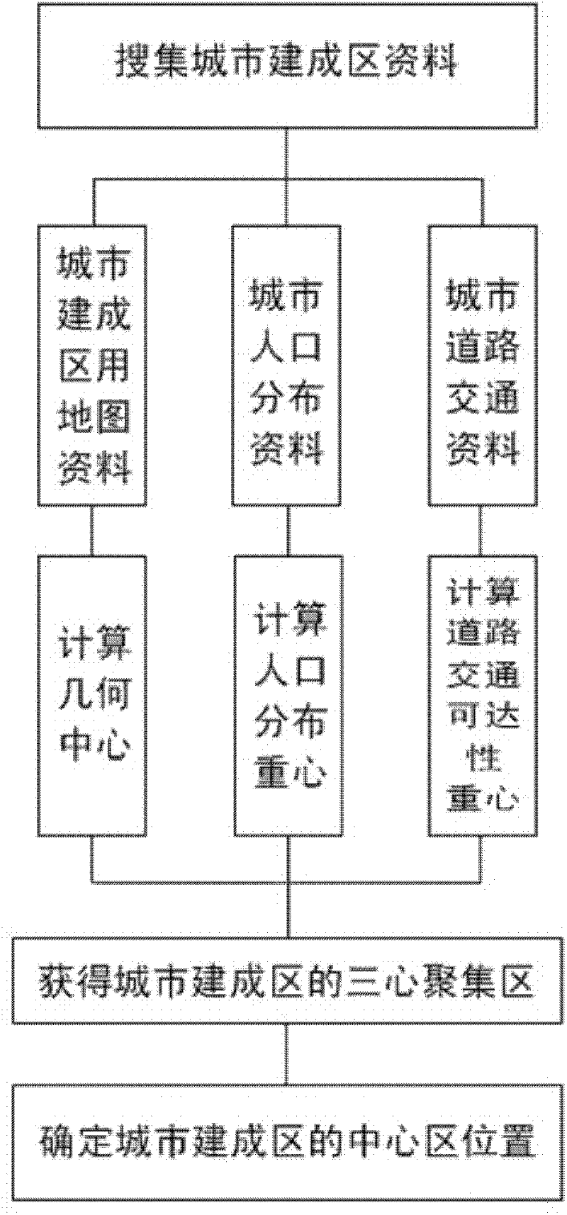
[0070] The present invention determines the geometric center of gravity of urban built-up areas, the center of gravity of urban population distribution and the center of gravity of urban road traffic accessibility in the map of urban built-up areas, and connects the three centers of gravity in pairs, and the obtained area is the position of the city center; The size of the area corresponds to the aggregation intensity of each center of gravity, the smaller the area, the higher the aggregation intensity of the central area.

[0071] Introduce the concrete implementation of the present invention below, comprise the following steps:

[0072] (1) Calculate the geometric center of gravity of the urban built-up area.

[0073] Use Arcmap software to distinguish three different layers of "built-up area", "map spot" and "road network" in the urban built-up area map, and use the "Calculate Geometry" (geometric operation) function to calculate the "X Coordinate of Centroid ", "Y Coordin...


PUM


Abstract

The invention relates to a method for determining the position and the agglomeration intensity of a city core area. A city built-up area geometric centroid, a city population distribution centroid and a city road traffic accessibility centroid are determined in a map for the city built-up area, every two centroids are connected together to obtain an area, namely the city core area position; and the size of the core area corresponds to the agglomeration intensity of each centroid, that is, the smaller the size of the core area is, the higher the agglomeration intensity of the center area is. The invention provides a technology method for determining the position of the city core area, with the characteristics of integrity of theoretical basis, objectivity of data selection, scientificalness of calculation method, pertinency of space types or the like. The method used for determining the position and the agglomeration intensity of the city core area has more scientificalness, rationality and operability and provides a good platform for research on the core area.

Description

technical field [0001] The invention belongs to the technical field of urban planning, and relates to a method for determining the location and aggregation intensity of a city center. Background technique [0002] In the planning work such as research on urban spatial development trends, new city planning, and urban land use adjustment, it is necessary to determine the appropriate spatial location of the urban center. The urban central area is composed of dense service industry institutions, and its spatial distribution is closely related to various economic relations and economic activities; while different functions of the city have different spatial location requirements for land, such as office, commerce, finance, residence, education, etc. Industries such as industry, industry, and warehousing have different bidding capabilities for land rent, and the difference in land rent determined by different locations creates order in the free location selection of various instit...

Claims


Application Information

Patent Timeline
Patent Type & Authority Applications(China)
IPC IPC(8): G06Q10/06G06Q50/00G06F17/50
Inventor 杨俊宴谭瑛
Owner 南京东南大学城市规划设计研究院有限公司
Why Eureka
Try Eureka