A Method for Determining the Scale Threshold of Image Classification and Segmentation

An image classification and scale technology, applied in image analysis, image enhancement, image data processing, etc., can solve the problems of inaccurate estimation of the optimal segmentation scale, time-consuming, and a lot of time, to achieve scientific and persuasive , accurate results, and shortened time

Active Publication Date: 2020-11-10
GUANGZHOU INST OF GEOGRAPHY GUANGDONG ACAD OF SCI
View PDF7 Cites 0 Cited by
  • Summary
  • Abstract
  • Description
  • Claims
  • Application Information

AI Technical Summary

Problems solved by technology

[0004] Image segmentation is based on the discontinuity and similarity features of image brightness values ​​as reference values, based on homogeneity or heterogeneity criteria, see figure 1 , set the optimal segmentation scale to divide the image into several sub-regions, but currently there is no accurate estimation of the optimal segmentation scale in this process, relying on empirical thresholds to set the segmentation scale to segment remote sensing data of different scales takes a lot of time Completing multiple experiments with remote sensing engineers with better skills to gain experience is the most time-consuming process in OBIA

Method used


Image

  • A Method for Determining the Scale Threshold of Image Classification and Segmentation
  • A Method for Determining the Scale Threshold of Image Classification and Segmentation
  • A Method for Determining the Scale Threshold of Image Classification and Segmentation

Examples


Embodiment Construction

[0037] The technical solutions in the embodiments of the present invention will be clearly and completely described below in conjunction with the drawings and embodiments. Apparently, the described embodiments are only some of the embodiments of the present invention, not all of them.

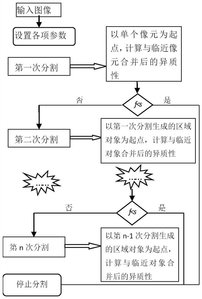
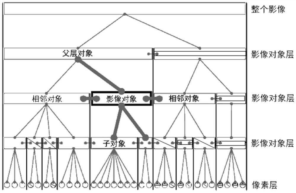
[0038] see Figure 1 to Figure 3 , figure 1 It is a conventional heterogeneity segmentation estimation method. The method of image segmentation is to perform multiple segmentations at different scales to form a network hierarchy. See figure 2 , each segmentation uses lower-level image objects as raw materials, which are then merged in the new segmentation. At the same time, the object boundary constraints in the parent layer are also respected. This network structure is a topological relationship. For example, the boundary of the parent layer object determines the boundary of the child object, and the area size of the parent layer object is determined by the sum of the child objects. Each l...


PUM


Abstract

The invention discloses a method of determining an image classification segmentation scale threshold. The method comprises steps: a remote sensing image is inputted and image parameters and an initial segmentation scale are set, wherein the image parameters comprise a spectrum and a shape factor; a heterogeneity segmentation estimation algorithm is adopted to carry out N segmentations with primary circulation on the remote sensing image, wherein N is the set segmentation times; in view of a network hierarchical structure formed after segmentation of the remote sensing image, the scale layer number is counted, analyzed and calculated, and the heterogeneity local variance of each layer and the variance variations between each layer and the upper layer and the lower layer are analyzed; and a layer number with a large variance variation is acquired, the heterogeneity index of the layer is further extracted and serves as a segmentation scale threshold. In remote sensing monitoring of the geographical condition, for multi-scale high-spatial resolution satellite remote sensing data, the segmentation scale estimation can be effectively solved, a reference scale is provided, the time cost needed in the process can be effectively solved, the geographical condition remote sensing monitoring efficiency is improved, and the classification efficiency can be effectively improved.

Description

technical field [0001] The invention relates to the field of spatial image analysis, in particular to a method for determining a scale threshold for image classification and segmentation. Background technique [0002] my country has a vast territory and a large population. It is currently in a transitional period of rapid economic development. Surface changes are detailed and frequent, and its geographical conditions are huge and complex. Faced with such a situation, geographic national conditions monitoring is an important mission of spatial information science in the new era, and its implementation requires the use of air-space-ground integrated remote sensing technology and global satellite navigation and positioning technology to achieve integrated information collection and rapid update. To a large extent, the timeliness and comprehensiveness of the monitoring objects of geographical conditions require that the earth observation has a strong ability to collect and updat...

Claims


Application Information

Patent Timeline
Patent Type & Authority Patents(China)
IPC IPC(8): G06T7/136
CPCG06T7/136G06T2207/10032
Inventor 金利霞曾献铁王洋叶玉瑶刘旭拢吴旗韬龚蔚霞王长建张玉玲范建红
Owner GUANGZHOU INST OF GEOGRAPHY GUANGDONG ACAD OF SCI
Why Eureka
Try Eureka