
Land-sea elevation datum unification technology

A datum, elevation technique used in height/level measurements, measuring devices, instruments, etc.

Inactive Publication Date: 2017-07-14
暴景阳
View PDF1 Cites 0 Cited by
  • Summary
  • Abstract
  • Description
  • Claims
  • Application Information

AI Technical Summary

Problems solved by technology

Therefore, the current ocean depth representation basically does not establish a necessary connection with the national unified elevation datum

Method used


Image

  • Land-sea elevation datum unification technology
  • Land-sea elevation datum unification technology
  • Land-sea elevation datum unification technology

Examples


Embodiment Construction

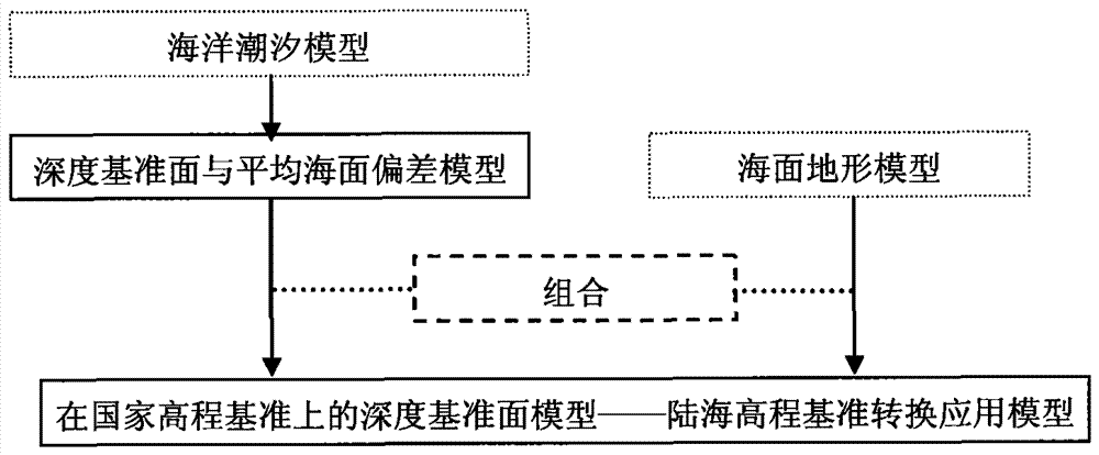
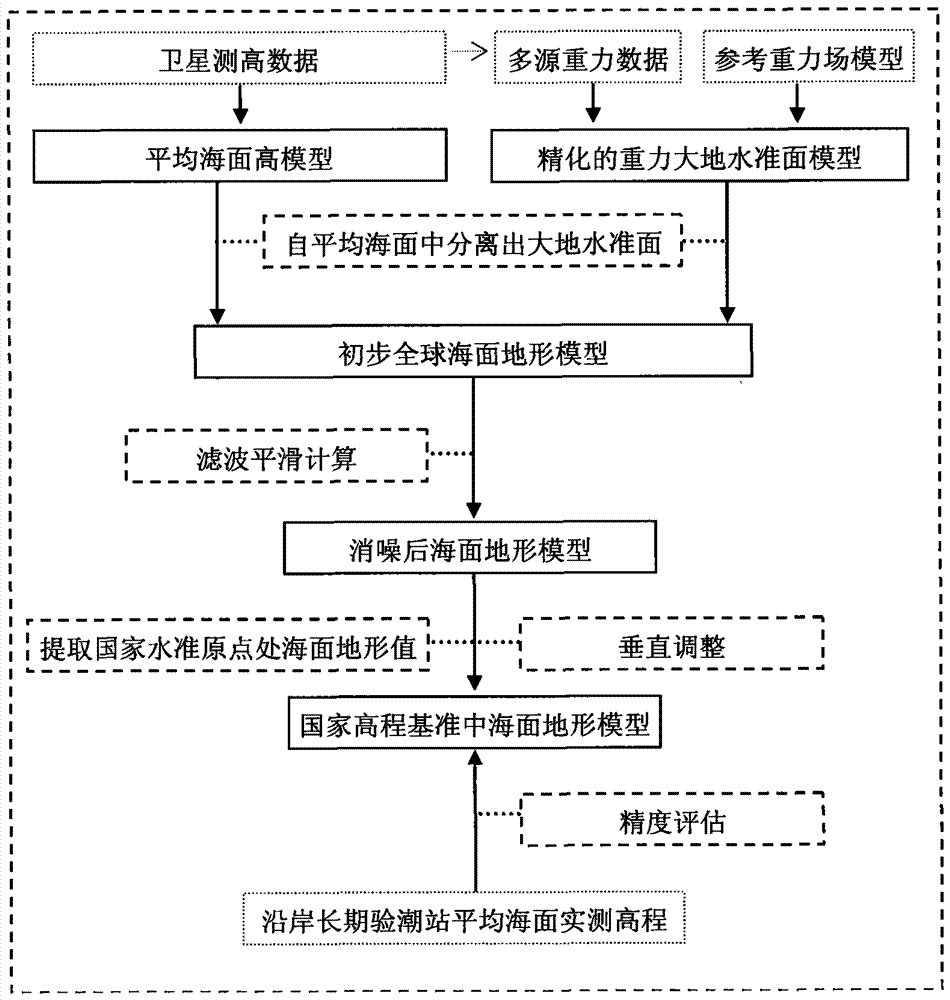
[0020] The technical key to the unification of land-sea elevation datum is to express the sea depth datum in the national elevation datum system, and to establish a numerical model of the geographical distribution relationship of the vertical deviation of the two datums, so as to realize the conversion and unification of the depth datum to the elevation datum.

[0021] The depth datum is defined as the theoretical lowest tidal level in my country. In practice, it is determined by the tidal harmonic constant, which means the theoretical minimum that the tidal action may reach. The principle formula for calculation is:

[0022]

[0023] Note the expression for tidal height in the formula The constant item of zero frequency is not included, that is, this item is taken as "0", which indicates that the depth datum is calculated from the equilibrium position of tidal vibration (that is, the ideal tidal-free sea surface), and at the same time indicates that the depth datum is a fr...


PUM


Abstract

The land-sea elevation datum unification technology belongs to the invention patent in the field of geodesy and surveying engineering technology. The depth of the ocean area and the elevation of land and islands are all vertical parameters of basic geographic information, but different benchmarks are used in data acquisition, processing and application. Establishing the relationship between the two types of datums is an urgent and realistic requirement to realize the unification and integrated expression of land and sea geographic information data. Based on this, according to the fact that the depth reference is a specific low tide surface and is usually expressed by the mean sea level as the reference surface, the present invention proposes to use the tidal model to construct the numerical model of the depth reference surface grid, by establishing the national elevation The sea surface terrain model expressed in the datum realizes the expression of the depth datum in the national elevation datum, and completes the conversion and unification of the ocean depth datum to the land elevation datum.

Description

technical field [0001] The invention is a technique for unifying land and sea elevation datums, and belongs to the basic work and technical field of establishing, perfecting and maintaining geodetic datums in the subject of "geodesy and surveying engineering". Background technique [0002] The depth of the ocean area and the elevation of land and islands are all vertical parameters of basic geographic information, but different benchmarks are used in data acquisition, processing and application. Establishing the relationship between the two types of datums is an urgent and realistic requirement to realize the unification and integrated expression of land and sea geographic information data. [0003] Due to the dynamic fluctuation characteristics of the sea surface, the constraints of traditional hydrographic techniques, and the service goals mainly oriented to the compilation of nautical charts, the acquisition, processing and expression of ocean depth data use a specific ti...

Claims


Application Information

Patent Timeline
Patent Type & Authority Patents(China)
IPC IPC(8): G01C5/00
Inventor 暴景阳郭春喜周兴华章传银许军
Owner 暴景阳
Learn More