GNSS imaging method constructed based on inter-station correlation spatial structure function

A technology of spatial structure and imaging method, applied in instruments, measuring devices, calculations, etc., to overcome the shortcomings of temporal resolution, high temporal resolution and reliability, and improve cognition

Active Publication Date: 2019-11-08
WUHAN UNIV
View PDF11 Cites 0 Cited by
  • Summary
  • Abstract
  • Description
  • Claims
  • Application Information

AI Technical Summary

Problems solved by technology

[0003] Using these dense GNSS monitoring networks, it is possible to reasonably use GNSS time series to determine station velocity and its uncertainty, so as to image crustal deformation; however, using GNSS imaging technology, the bottleneck problems encountered include how to construct spatial structure function

Method used


Image

  • GNSS imaging method constructed based on inter-station correlation spatial structure function
  • GNSS imaging method constructed based on inter-station correlation spatial structure function
  • GNSS imaging method constructed based on inter-station correlation spatial structure function

Examples


Embodiment Construction

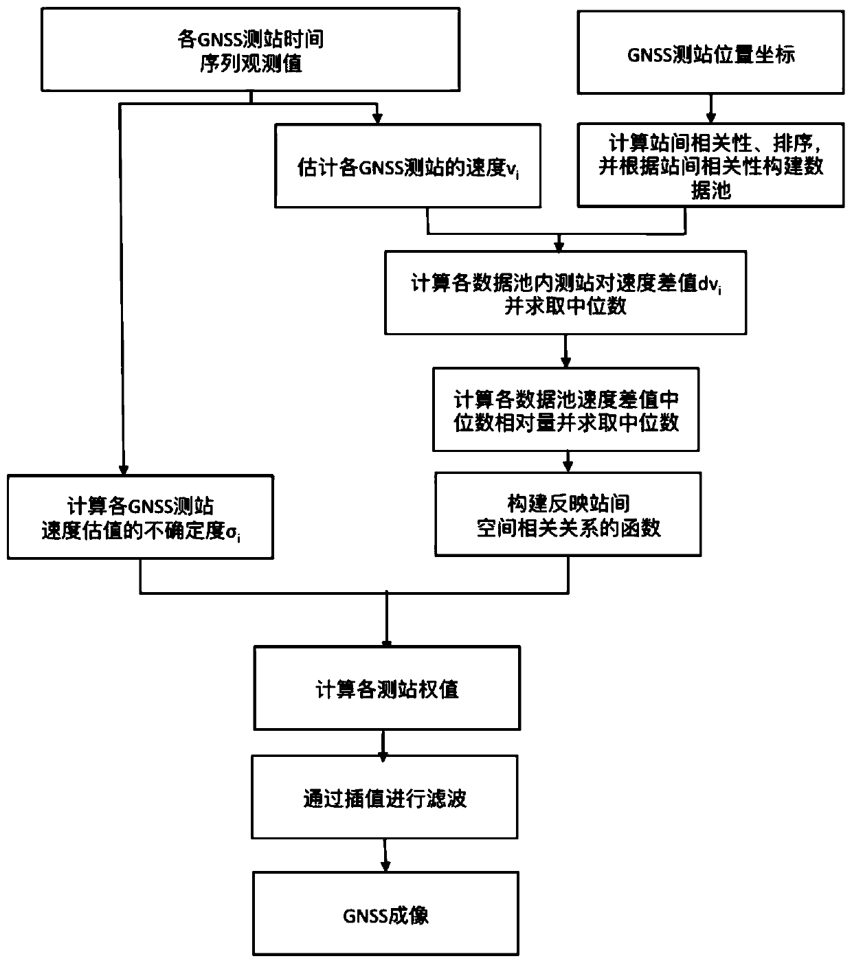
[0026] In order to make the purpose, technical solutions and beneficial effects of the present invention more clear, the present invention will be further described below in conjunction with the accompanying drawings and embodiments.

[0027] see figure 1 , the GNSS imaging method constructed based on the inter-station correlation spatial structure function provided by the embodiment of the present invention comprises steps:

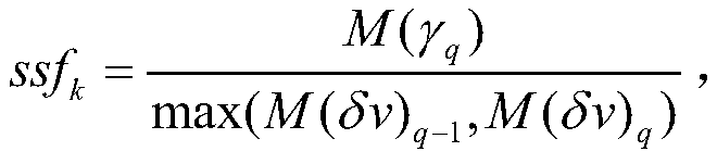
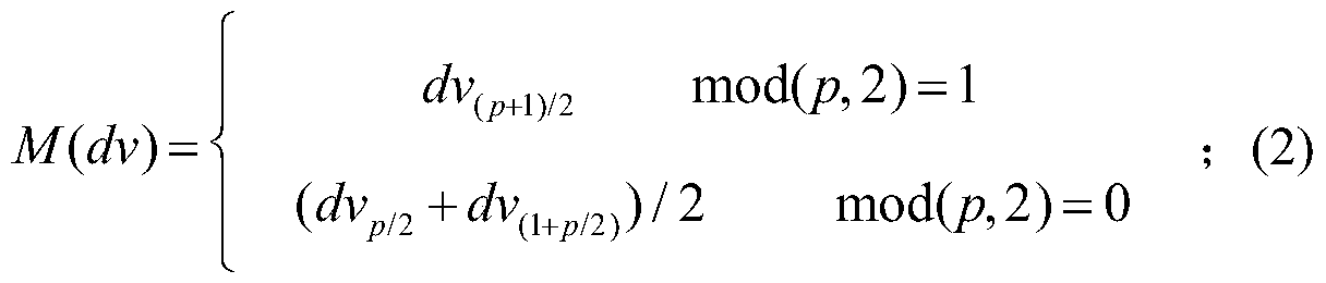
[0028] Step 1, input the GNSS station coordinate time series observations, and the velocity v of each GNSS station n and its uncertainty σ n (n=1, 2, ..., N); Wherein, N is the total number of GNSS measuring stations in the whole GNSS network, and n is the label of the GNSS measuring stations in the whole GNSS network;

[0029] Step 2, combining the geology and geodesy results of the study area (such as geological fault location information, active block division model based on long-term GPS observations, etc.), cluster and divide the stations in the G...


PUM


Abstract

The invention provides a GNSS imaging method based on inter-station correlation spatial structure function construction, including inputting GNSS station coordinate time series observation values, and the speed and uncertainty of each GNSS station; combining geology and According to the results of geodesy, the stations in the GNSS network are clustered and divided to obtain the cluster area; the correlation coefficient between the station pairs formed by any two stations in each cluster area is calculated, and the correlation coefficient between the stations is calculated. Data pool division, obtain several data pools in each cluster area and GNSS station pairs in each data pool; in each cluster area, calculate the median and absolute correlation coefficient of all station pairs in each data pool Median difference, construct the spatial structure function of each clustering area, and standardize to form the final spatial structure function of the entire GNSS network; according to the velocity uncertainty and spatial structure function, determine the weight of all stations within the research range, and use the spatial interpolation method Spatial interpolation to form an image.

Description

technical field [0001] The invention belongs to the technical field of precise processing of GNSS data, and relates to a GNSS imaging method for constructing a spatial structure function based on time series of GNSS multi-stations. Background technique [0002] In recent years, the GPS / GNSS monitoring network has been put into operation, and the coverage has been greatly expanded, and the number of stations is increasing day by day, including the Chinese crustal movement observation network and the Chinese mainland tectonic environment monitoring network, the PBO network in the United States, and the EPN in Europe. , Japan's GEONET and other networks have produced a large amount of observation data that grows exponentially. [0003] Using these dense GNSS monitoring networks, it is possible to reasonably use GNSS time series to determine station velocity and its uncertainty, so as to image crustal deformation; however, using GNSS imaging technology, the bottleneck problems e...

Claims


Application Information

Patent Timeline
Patent Type & Authority Patents(China)
IPC IPC(8): G01S19/38G06K9/62
CPCG01S19/38G06F18/23213
Inventor 周晓慧姜卫平杨艺林范文蓝刘洋
Owner WUHAN UNIV
Why Eureka
Try Eureka