
Plane figure relation determining method and system in geographical information system

A technology of geographic information system and plane graphics, applied in the field of plane graphics relationship determination method and system, can solve the problems of inaccurate determination of plane graphics relationship, reduced query efficiency, increased system burden, etc., so as to avoid increased system burden, improve efficiency and Accuracy, the effect of ensuring accuracy

Active Publication Date: 2015-05-13
北京世纪天宇科技发展有限公司
View PDF4 Cites 0 Cited by
  • Summary
  • Abstract
  • Description
  • Claims
  • Application Information

AI Technical Summary

Problems solved by technology

[0004] This application provides a method and system for determining the relationship of plane graphics in a geographic information system, which can solve the problem of increased system burden and reduced query efficiency caused by multiple queries caused by inaccurate determination of plane graphics relationships or correction of query results

Method used


Image

  • Plane figure relation determining method and system in geographical information system
  • Plane figure relation determining method and system in geographical information system
  • Plane figure relation determining method and system in geographical information system

Examples


Embodiment 1

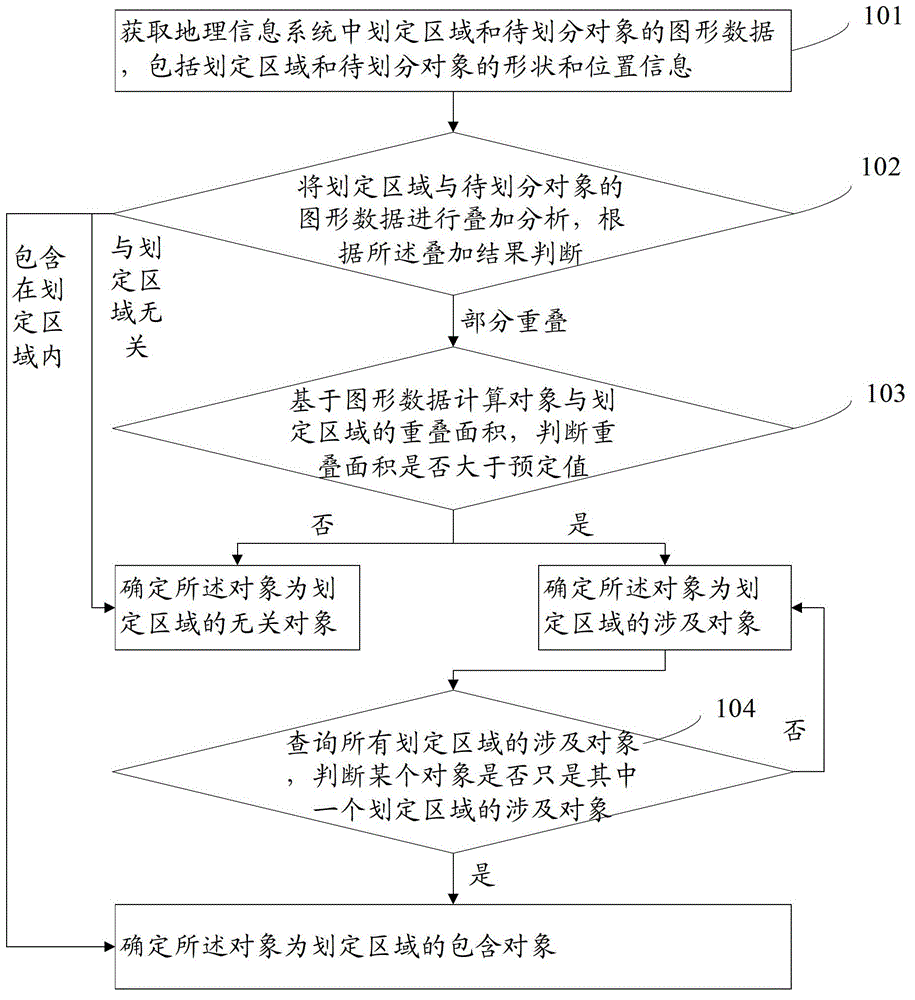
[0043] refer to figure 1 , which shows a first embodiment of a method for determining a plane graphic relationship in a geographic information system of the present application, including the following steps:

[0044] Step 101, acquiring graphic data of a defined area and an object to be divided in a geographic information system, the graphic data including shape and position information of the defined area and the object to be divided.

[0045] The designated area can be a certain city, county, district, or a river basin, etc., or it can be an area within a specified location range, such as an area within a certain range of accuracy and dimension.

[0046] The object to be divided can be determined according to the actual situation, for example, it can be a village, township, or town to be divided.

[0047] The shape and position information of the demarcated area and the object to be divided refers to information that can indicate the shape and size of the demarcated area an...


PUM


Abstract

The invention provides a plane figure relation determining method in a geographical information system. The plane figure relation determining method comprises the following steps of: obtaining figure data of a divided region and an object to be divided in the geographical information system; overlapping the object to be divided and the figure data of the divided region, if the object to be divided is in the divided region, determining the object to be divided to be a contained object, and if the object to be divided is not related with the divided region, determining the object to be divided to be a non-related object; if the object to be divided is partially overlapped with the divided region, carrying out the next step; calculating an overlapping area and judging whether the overlapping area is greater than a pre-set value or not, if so, determining the object to be divided to be a related object, otherwise, determining the object to be divided to be a non-related object; and if a certain object is the related object in one divided region, changing the object into a contained object. The invention further provides a plane figure relation determining system in the geographical information system, which is used for realizing the method disclosed by the invention. The method and the system disclosed by the invention can provide an accurate plane figure relation, so that many times of inquiry are avoided or an inquiry result is revised, the system load is reduced and the inquiry efficiency is improved.

Description

technical field [0001] The present application relates to the technical field of geographic information systems, in particular to a method and system for determining the relationship of plane graphics in geographic information systems. Background technique [0002] As an important spatial information system, geographic information system provides help to more and more people. Geographic information system is mainly supported by computers to collect, store, store, and store various geospatial entity data and their relationships in the entire or part of the earth's surface space, including spatial positioning data, graphic data, remote sensing image data, attribute data, etc. Technical systems for management, computation, analysis and description. A large amount of vector data will be used in the geographic information system, because the vector data structure can intuitively express the geographical space, and can accurately represent the spatial position and attributes of t...

Claims


Application Information

Patent Timeline
Patent Type & Authority Patents(China)
IPC IPC(8): G06F17/30
Inventor 李嵩郑国柱
Owner 北京世纪天宇科技发展有限公司
Learn More