Tap water supply pipe network management system of geographic information system (GIS)

A water supply network and management system technology, applied in the field of information processing, can solve problems such as difficult estimation of user influence, slow update speed, and difficult confirmation of valve positions

Inactive Publication Date: 2013-04-10
镇江佳得信息技术有限公司
View PDF1 Cites 3 Cited by
  • Summary
  • Abstract
  • Description
  • Claims
  • Application Information

AI Technical Summary

Problems solved by technology

With the rapid development of the city, there are many problems in the management of the pipe network, such as: the pipe network map is not accurate and the update speed is slow; the position of the valve is difficult to confirm on site; when the water is cut off at a certain point in the pipe network, which valves need to be closed ; It is difficult to estimate which users will be affected by closing these valves, and it is difficult to solve these problems manually

Method used


Image

  • Tap water supply pipe network management system of geographic information system (GIS)

Examples


Embodiment Construction

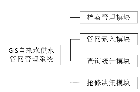
[0013] The module schematic diagram of the GIS tap water supply pipe network management system of the present invention is as figure 1 As shown, the system includes the following modules: map file management module, pipe network entry module, query statistics module and emergency repair decision-making module;

[0014] The graphic file management module is used to store all spatial graphic data;

[0015] The pipe network input module is used for digitizing graphic data and inputting attribute data;

[0016] The query statistics module is used to query the exact geographic location of elements through attribute information of pipe network elements, and to query all attribute information by clicking on element graphics on the map;

[0017] The emergency repair decision-making module is used to provide decision-making through spatial analysis of the GIS system.

[0018] The drawing file management module can register and cancel raster maps and as-built maps; browse the status o...


PUM


Abstract

The invention discloses a tap water supply pipe network management system of a GIS and belongs to the field of information processing. The system comprises a drawing and document management module, a pipe network entry module, a query and statistics module and an emergency maintenance decision module, wherein the drawing and document management module is used for storing all spatial graphic data, the pipe network entry module is used for digitizing the graphic data and entering attribute data, the query and statistics module is used for querying accurate geographic positions of elements through pipe network element attribute information and querying all attribute information of element graphs through clicking of element graphs on a map, and the emergency maintenance decision module is used for providing decisions through spatial analyses of the GIS. The system integrates functions of storage, searching, statistics, analysis, calculation and dynamic service management of pipe network information, and the intelligent management of pipe network information of a city can be achieved.

Description

technical field [0001] The invention belongs to the field of information processing, in particular to a GIS water supply pipe network management system. Background technique [0002] The dynamic monitoring of the water pipe network is one of the important contents of the automation construction of the water plant. With the rapid development of the city, there are many problems in the management of the pipe network, such as: the pipe network map is not accurate and the update speed is slow; the position of the valve is difficult to confirm on site; when the water is cut off at a certain point in the pipe network, which valves need to be closed It is difficult to estimate which users will be affected by closing these valves, and it is difficult to solve these problems manually. Contents of the invention [0003] GIS water supply pipe network management system, including: map file management module, pipe network input module, query statistics module and emergency repair deci...

Claims


Application Information

Patent Timeline
Patent Type & Authority Applications(China)
IPC IPC(8): G06Q10/06G06Q50/06G06F17/30
Inventor 牛凯
Owner 镇江佳得信息技术有限公司
Why Eureka
Try Eureka