
Method and device for dynamic rendering of 3D model map

A three-dimensional model, dynamic technology, applied in the field of image processing

Active Publication Date: 2016-05-18
GUANGDONG VTRON TECH CO LTD
View PDF3 Cites 0 Cited by
  • Summary
  • Abstract
  • Description
  • Claims
  • Application Information

AI Technical Summary

Problems solved by technology

How to do some analysis on thousands of 3D buildings, effectively visually view and identify massive buildings, and 3D visualization information analysis and statistical results are beyond the reach of traditional GIS

Method used


Image

  • Method and device for dynamic rendering of 3D model map
  • Method and device for dynamic rendering of 3D model map
  • Method and device for dynamic rendering of 3D model map

Examples


Embodiment Construction

[0031] The present invention is based on osgEarth, which is a real-time terrain model loading and rendering tool developed based on OSG (OpenSceneGraph).

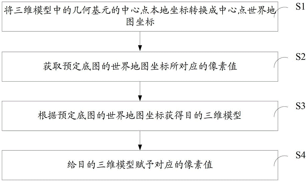
[0032] This invention proposes a dynamic rendering method for 3D model maps, please refer to figure 1 , including the steps:

[0033] S1. Convert the local coordinates of the center point of the geometric primitive in the three-dimensional model into the world map coordinates of the center point;

[0034] First, the osgearth engine loads the Shapefile file containing the building height attribute, stretches it into a 3D model and renders it according to the building height attribute. Read all the geometric primitives; among them, the geometric primitives include: the geometric primitives of the wall, the geometric primitives of the roof, the local coordinate range of the wall, the local coordinate range of the roof, the number of floors, etc.; Shapefile Used to describe geometric objects: points, polylines and polygons. ...


PUM


Abstract

The present invention proposes a three-dimensional model map dynamic rendering method, comprising the steps of: converting the local coordinates of the center point of the geometric primitives in the three-dimensional model into the world map coordinates of the center point; obtaining the pixel value corresponding to the world map coordinates of the predetermined base map; Obtaining a target three-dimensional model according to the world map coordinates of the predetermined base map; assigning corresponding pixel values ​​to the target three-dimensional model. The specified terrain and the 3D buildings on the terrain can be rendered into a specific state to visually identify the buildings.

Description

technical field [0001] The invention relates to the field of image processing, in particular to a method and device for dynamic rendering of a three-dimensional model map. Background technique [0002] With the deepening of GIS application, GIS needs to store and manage a large amount of spatial information and attribute information. How to do some analysis on thousands of 3D buildings, effectively visually view and identify massive buildings, and 3D visualization information analysis and statistical results are beyond the reach of traditional GIS. Contents of the invention [0003] The invention provides a dynamic rendering method and device for a three-dimensional model map, which can render the designated terrain and three-dimensional buildings on the terrain into a specific state, and intuitively recognize the buildings. [0004] The scheme adopted: [0005] A method for dynamically rendering a three-dimensional model map, comprising the steps of: [0006] Convert t...

Claims


Application Information

Patent Timeline
Patent Type & Authority Patents(China)
IPC IPC(8): G06T15/00G09B29/10
Inventor 林良辉
Owner GUANGDONG VTRON TECH CO LTD
Learn More