Method for planning moving path of multi-anchor-node set of wireless sensor network

A wireless sensor and moving path technology, applied in network planning, wireless communication, electrical components, etc., can solve problems such as low positioning accuracy, low positioning coverage, and reduced network positioning rate.

Active Publication Date: 2013-09-25
深圳宏安通信科技有限公司
View PDF4 Cites 24 Cited by
  • Summary
  • Abstract
  • Description
  • Claims
  • Application Information

AI Technical Summary

Problems solved by technology

[0011] 2. The traditional path planning method has edge problems and collinear problems in path planning, which lead to low positioning accuracy, low positioning coverage and high energy consumption.
[0012] 3. Most path planning methods use a mobile anchor node. Although it can save network costs, it reduces the positioning rate of the entire network, which is limited in practical applications.

Method used


Image

  • Method for planning moving path of multi-anchor-node set of wireless sensor network
  • Method for planning moving path of multi-anchor-node set of wireless sensor network
  • Method for planning moving path of multi-anchor-node set of wireless sensor network

Examples


Embodiment Construction

[0050] The present invention will be further described below in conjunction with the accompanying drawings.

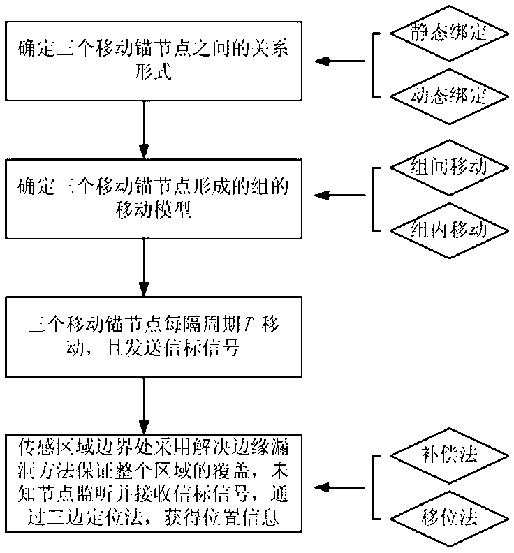
[0051] Such as figure 1 As shown, a wireless sensor network multi-anchor node group mobile path planning method, the steps include:

[0052] (1) Determine the relationship form between the three mobile anchor nodes according to the application requirements;

[0053] (2) Determine the mobility model of the group formed by three mobility anchor nodes;

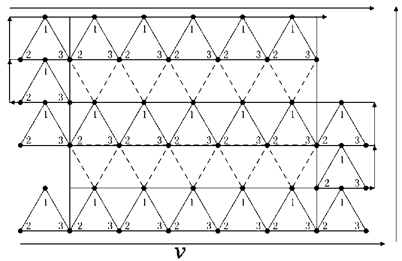
[0054] (3) The three mobile anchor nodes move and send beacon signals every period T;

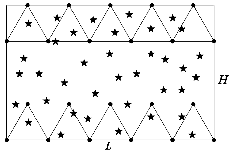
[0055] (4) At the boundary of the sensing area, the method of solving the edge loopholes is adopted to ensure the coverage of the entire area. The unknown nodes continuously monitor and receive the beacon signal, and obtain the position information through the trilateral positioning method.

[0056] The range of period T for the three mobile anchor nodes to move and send beacon signals is, T tra max ;

[0057] Among them, T tra i...


PUM


Abstract

The invention relates to a method for planning a moving path of a multi-anchor-node set of a wireless sensor network. The wireless sensor network comprises a plurality of static unknown nodes and three movable anchor nodes. The method comprises the steps that a dynamic binding relationship and a static binding relationship exist among the three movable anchor nodes and a relationship mode among the three movable anchor nodes is firstly determined; a moving model of the multi-anchor-node set is determined according to environment application requirements, the relationship mode of the three movable anchor nodes, and the positions of the three anchor nodes and energy surplus of the three anchor nodes in a zone; the three movable anchor nodes are located on the peak portions of an equilateral triangle respectively, beacon signals are moved and sent every period T according to the determined moving model, covering of the whole zone is guaranteed by means of the adoption of two kinds of margin loophole solution methods when the beacon signals move to the boundary of the sensing zone, beacon information is continuously monitored and received by the unknown nodes, and position information is obtained through a trilateration method. The method is capable of effectively assisting in location and improving the location accuracy and the location covering rate.

Description

technical field [0001] The invention belongs to the field of wireless sensor networks, in particular to a mobile path planning method for multi-anchor node groups in a wireless sensor network. Background technique [0002] In recent years, wireless sensor networks (Wireless Sensor Networks, WSN) have developed rapidly and are widely used in the fields of environment, military, security, industry and furniture. The precise location information of sensor nodes is of great significance to the application of WSN. At present, scholars have proposed many positioning mechanisms for WSN. Many positioning mechanisms use static anchor nodes. In practical applications, there are problems of low positioning accuracy, low positioning coverage, and high network costs. To solve these problems, a localization method using mobile anchor nodes to assist node localization is proposed. The mobility models of mobile anchor nodes are mainly divided into two categories: random mobility models and...

Claims


Application Information

Patent Timeline
Patent Type & Authority Applications(China)
IPC IPC(8): H04W64/00H04W16/18
Inventor 韩光洁巢佳郭惠张晨语钱爱华江金芳江旭
Owner 深圳宏安通信科技有限公司
Why Eureka
Try Eureka