Measurement method of transverse meridian curvature radius of inertial navigation system

A technology of inertial navigation system and radius of curvature, which is applied in the field of measurement of the radius of curvature of the transverse meridian of the inertial navigation system, to achieve the effects of reducing measurement errors, improving navigation accuracy, and simple and convenient measurement methods

Inactive Publication Date: 2013-11-13
HARBIN ENG UNIV
View PDF8 Cites 3 Cited by
  • Summary
  • Abstract
  • Description
  • Claims
  • Application Information

AI Technical Summary

Problems solved by technology

[0004] The purpose of the embodiments of the present invention is to provide a method for measuring the radius of curvature of the transverse meridian of the inertial navigation system, which aims to solve the problem that when the inertial navigation system enters the polar region, the inertial navigation system needs to use real-time transverse meridian when it works in the polar region mode. Problems with Surface Curvature Radius Measurements

Method used


Image

  • Measurement method of transverse meridian curvature radius of inertial navigation system
  • Measurement method of transverse meridian curvature radius of inertial navigation system
  • Measurement method of transverse meridian curvature radius of inertial navigation system

Examples


Embodiment Construction

[0030] In order to make the object, technical solution and advantages of the present invention more clear, the present invention will be further described in detail below in conjunction with the examples. It should be understood that the specific embodiments described here are only used to explain the present invention, not to limit the present invention.

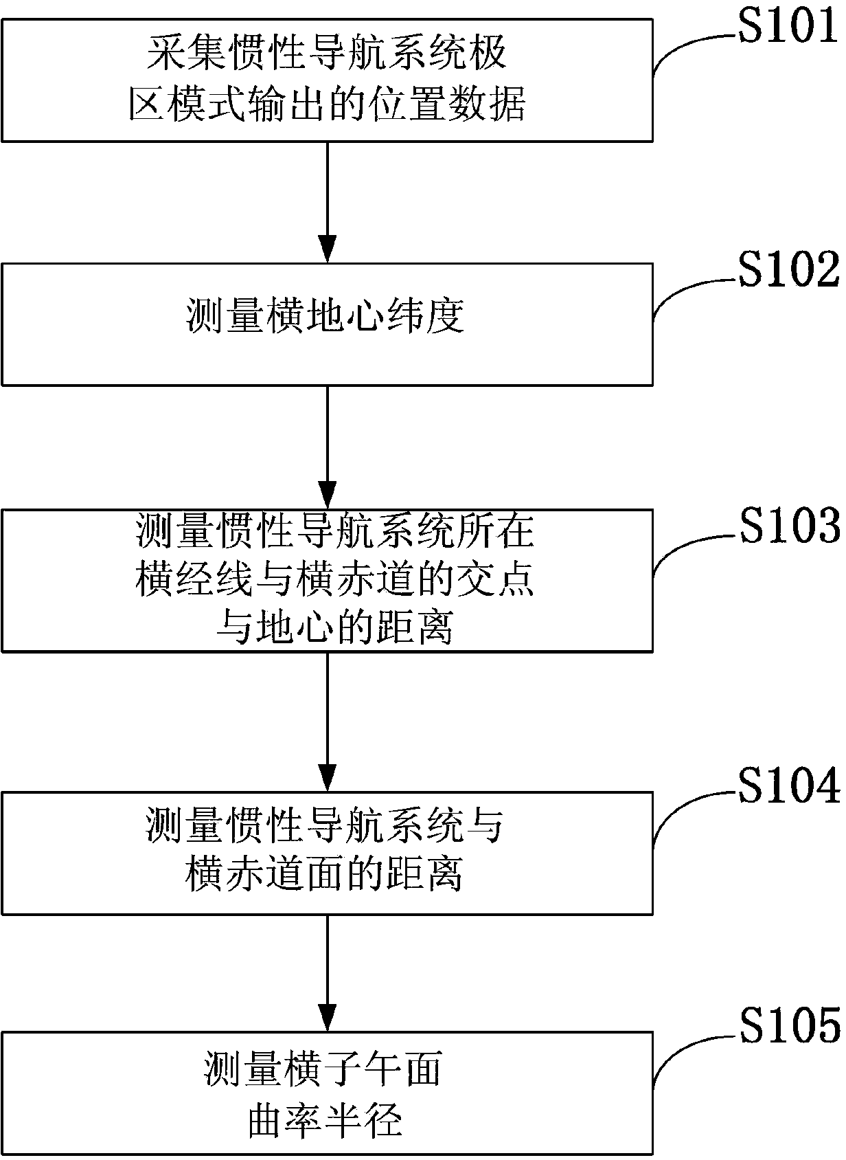
[0031] figure 1 The flow chart of the method for measuring the radius of curvature of the transverse meridian of the inertial navigation system provided by the present invention is shown. For ease of illustration, only the parts relevant to the present invention are shown.

[0032] The measuring method of the radius of curvature of the transverse meridian of the inertial navigation system of the present invention, the measuring method of the radius of curvature of the transverse meridian of the inertial navigation system comprises the following steps:

[0033] Collect the position data output by the polar mode of the iner...


PUM


Abstract

The invention discloses a measurement method of the transverse meridian curvature radius of an inertial navigation system. The measurement method comprises the following steps: collecting position data output by a polar area mode of the inertial navigation system; measuring the transverse geocentric latitude; measuring the distance between an intersection point of a transverse meridian on which the inertial navigation system is arranged and a transverse equatorial plane and the geocentre; measuring the distance between the inertial navigation system and the transverse equatorial plane; measuring the transverse meridian plane curvature radius. By adopting the measurement method, the transverse meridian plane curvature radius can be measured by using the position output by the polar area mode of the inertial navigation system on the basis of an earth ellipsoid model; a measurement error caused by an inaccurate earth model is reduced in principle; the navigation accuracy is improved; meanwhile, the measurement method is simple and convenient; the practical application is facilitated. By adopting the measurement method, the blank of the measurement method of the transverse meridian plane curvature radius of the earth under a transverse coordinate system is filled; the computing problem of mechanical layout of the inertial navigation system under a reference frame of the transverse coordinate system is solved. Thus, the problem of the polar area navigation of the inertial navigation system is solved.

Description

technical field [0001] The invention belongs to the technical field of polar area navigation of an inertial navigation system, and in particular relates to a method for measuring the radius of curvature of a transverse meridian of an inertial navigation system. Background technique [0002] The inertial navigation system is very important to ensure the navigation and operation of ships, aircraft and other carriers in polar regions. However, the current fixed north orientation inertial navigation system used by ships in our country cannot be used in polar regions due to its mechanical arrangement. In order to overcome the shortcoming that the above-mentioned mechanical arrangement of the inertial navigation system cannot perform navigation calculations in polar regions, researchers in the field of navigation have designed free azimuth and swimming azimuth mechanical arrangements. The free azimuth system and the swimming azimuth system have taken measures on the azimuth comma...

Claims


Application Information

Patent Timeline
Patent Type & Authority Applications(China)
IPC IPC(8): G01C21/20
Inventor 奔粤阳鲍桂清杨祥龙林星辰阮双双赵维珩叶攀尹冬寒
Owner HARBIN ENG UNIV
Why Eureka
Try Eureka