Remote sensing image land utilization scene classification method based on two-dimension wavelet decomposition and visual sense bag-of-word model

A scene classification and remote sensing image technology, applied in the field of remote sensing image scene classification, can solve the problem of insufficient utilization of texture information, and achieve the effect of improving the utilization degree and classification accuracy and high accuracy.

Active Publication Date: 2013-11-27
INST OF REMOTE SENSING & DIGITAL EARTH CHINESE ACADEMY OF SCI
View PDF2 Cites 21 Cited by
  • Summary
  • Abstract
  • Description
  • Claims
  • Application Information

AI Technical Summary

Problems solved by technology

The present invention adds the texture information of the land use scene image in the construction of the visual word bag model by using the two-dimensional wavelet decomposition method, which makes up f...

Method used


Image

  • Remote sensing image land utilization scene classification method based on two-dimension wavelet decomposition and visual sense bag-of-word model
  • Remote sensing image land utilization scene classification method based on two-dimension wavelet decomposition and visual sense bag-of-word model
  • Remote sensing image land utilization scene classification method based on two-dimension wavelet decomposition and visual sense bag-of-word model

Examples


Embodiment Construction

[0047] The present invention will be further elaborated below through the embodiments in conjunction with the accompanying drawings of the description.

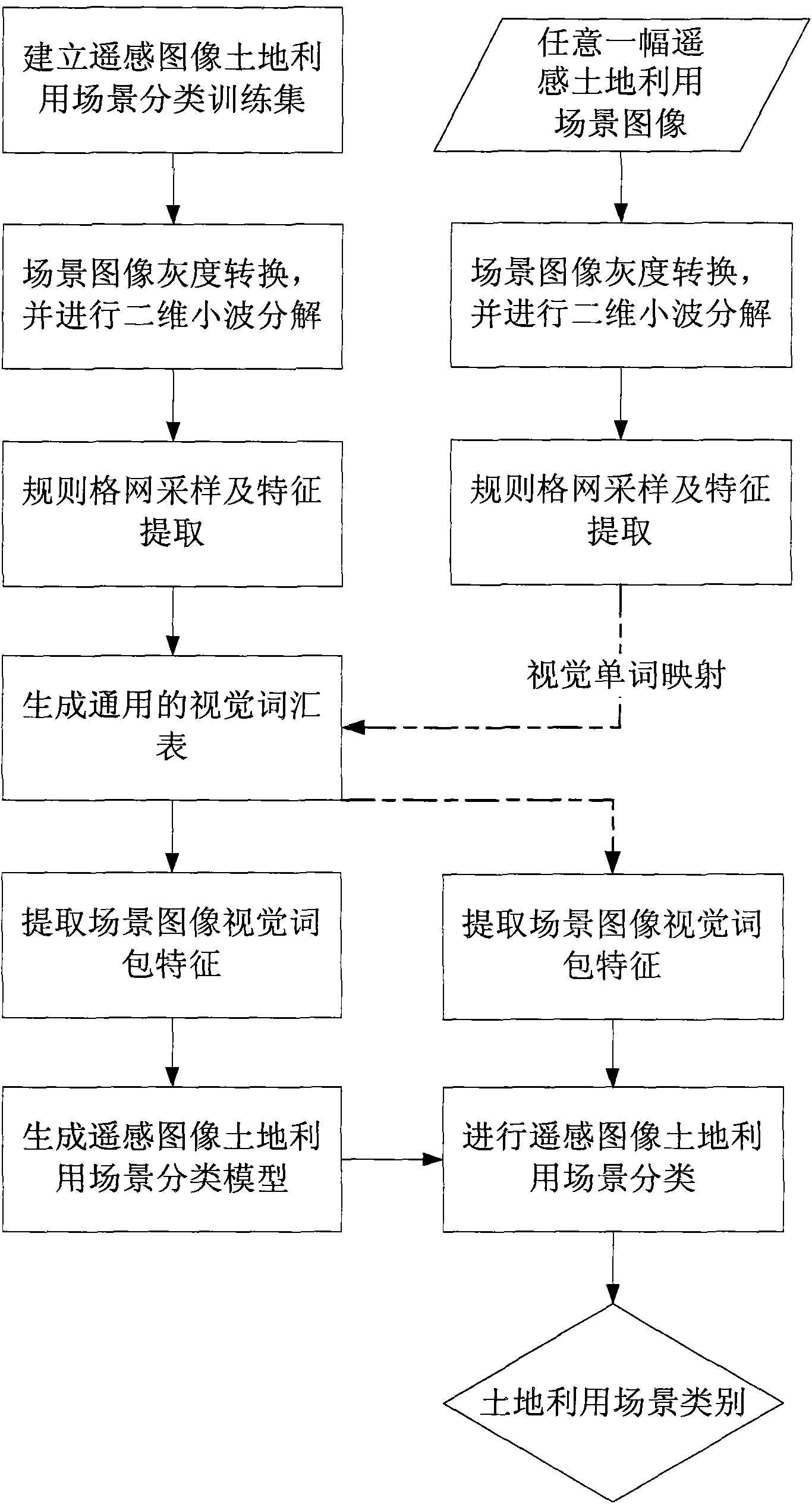
[0048] figure 1 It is a flow chart of the remote sensing image land use scene classification method based on two-dimensional wavelet decomposition and visual word bag model in the present invention, and the specific steps include:

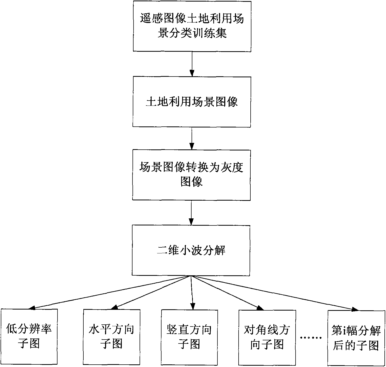
[0049] (1) Establish a remote sensing image land use scene classification training set;

[0050] (2) Convert the scene images in the remote sensing image land use scene classification training set to grayscale images, and perform two-dimensional wavelet decomposition;

[0051] (3) Sampling the converted gray-scale remote sensing land use scene image and sub-images decomposed by two-dimensional wavelet respectively in a regular grid and extracting scale invariant feature transform (SIFT);

[0052] (4) For all the images in the remote sensing image land use scene classification training set, the c...


PUM


Abstract

The invention relates to a remote sensing image land utilization scene classification method based on two-dimension wavelet decomposition and a visual sense bag-of-word model. The method comprises the steps that a remote sensing image land utilization scene classification training set is built; scene images in the training set are converted to grayscale images, and two-dimension decomposition is conducted on the grayscale images; regular-grid sampling and SIFT extracting are conducted on the converted grayscale images and sub-images formed after two-dimension decomposition, and universal visual word lists of the converted grayscale images and the sub-images are independently generated through clustering; visual word mapping is conducted on each image in the training set to obtain bag-of-word characteristics; the bag-of-word characteristics of each image in the training set and corresponding scene category serial numbers serve as training data for generating a classification model through an SVM algorithm; images of each scene are classified according to the classification model. The remote sensing image land utilization scene classification method well solves the problems that remote sensing image texture information is not sufficiently considered through an existing scene classification method based on a visual sense bag-of-word model, and can effectively improve scene classification precision.

Description

technical field [0001] The invention relates to the technical field of remote sensing image scene classification, in particular to a remote sensing image land use scene classification method based on two-dimensional wavelet decomposition and a visual word bag model. Background technique [0002] With the development of remote sensing technology and the improvement of spatial and temporal resolution, the data volume of remote sensing images, especially high spatial resolution remote sensing images, has increased rapidly, making land use scenes in images contain various types of land cover types. In this case, it takes a lot of time and workload to classify the land use scenes of remote sensing images using the method of manual visual interpretation, and limited experts cannot process the massive data in time. In view of the shortcomings of visual interpretation, automatic and intelligent land use scene classification using computer technology has become a research hotspot in ...

Claims


Application Information

Patent Timeline
IPC IPC(8): G06K9/62
Inventor 唐娉赵理君霍连志冯峥郑柯
Owner INST OF REMOTE SENSING & DIGITAL EARTH CHINESE ACADEMY OF SCI
Why Eureka
Try Eureka