Method and device for drawing three-dimensional enlarged intersection image
A technique for enlarging and three-dimensional intersections, which is applied in the computer field, can solve the problems of slow speed and low efficiency in drawing enlarged images of three-dimensional intersections
- Summary
- Abstract
- Description
- Claims
- Application Information
AI Technical Summary
Problems solved by technology
Method used
Image
Examples
Embodiment 1
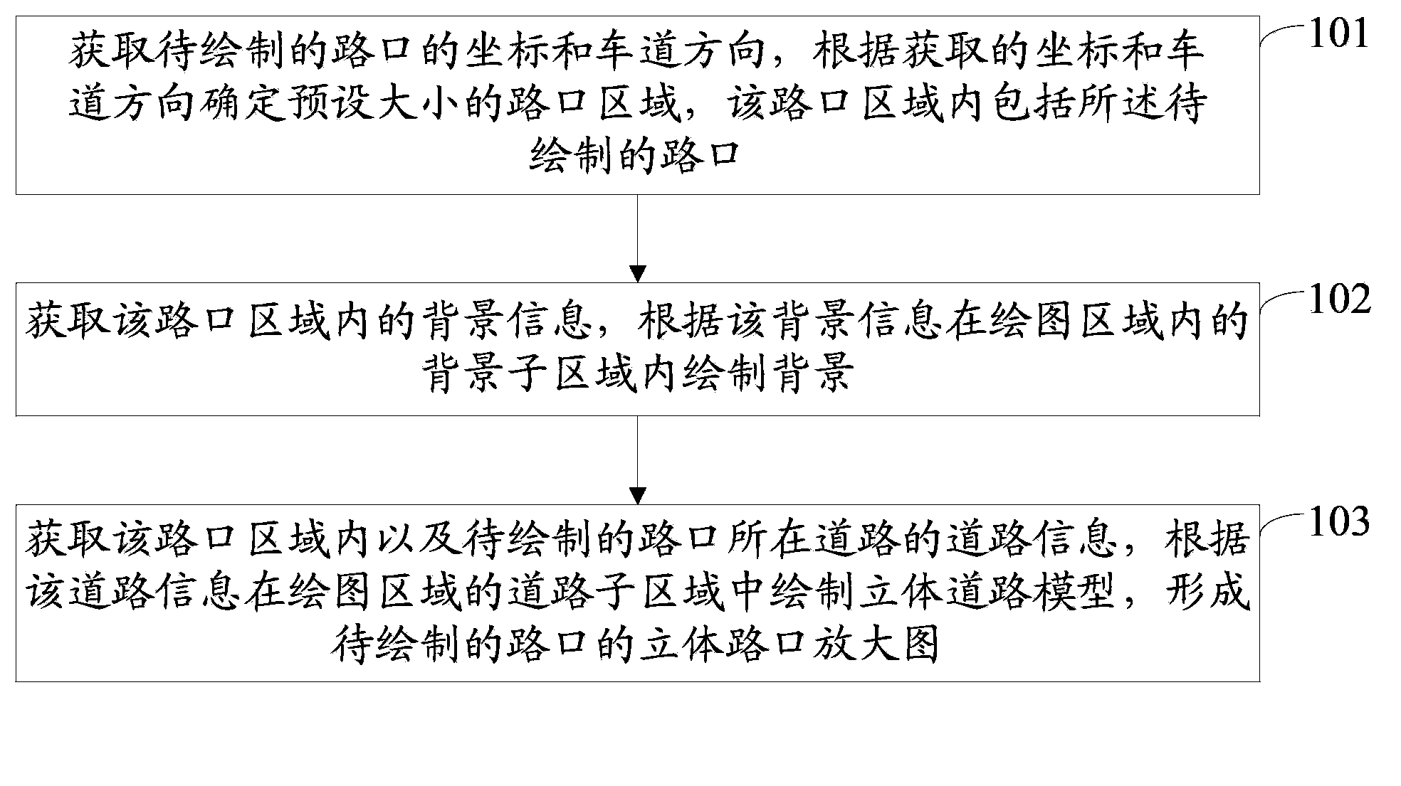
[0085] Such as figure 1 As shown, the embodiment of the present invention provides a method for drawing a three-dimensional intersection enlarged map, including:
[0086] Step 101: Obtain the coordinates and lane direction of the intersection to be drawn, and determine an intersection area of a preset size according to the acquired coordinates and lane direction, and the intersection area includes the intersection to be drawn;
[0087] Step 102: Obtain the background information in the intersection area, and draw the background in the background sub-area in the drawing area according to the background information;
[0088] Step 103: Obtain the road information of the intersection area and the road where the intersection to be drawn is located, draw a three-dimensional road model in the road sub-area of the drawing area according to the road information, and form an enlarged three-dimensional intersection map of the intersection to be drawn.
[0089] In the embodiment of t...
Embodiment 2
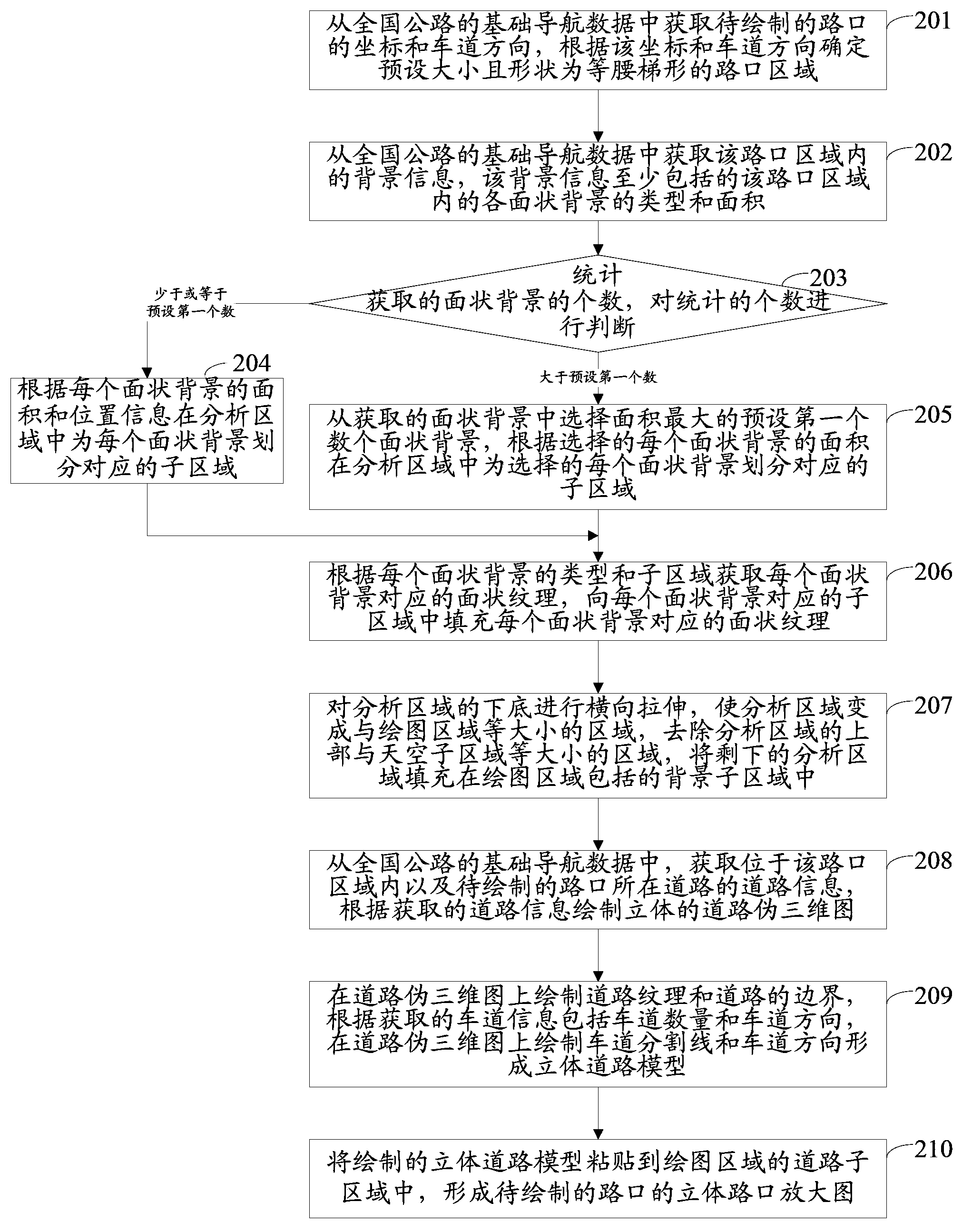
[0091] An embodiment of the present invention provides a method for drawing a three-dimensional intersection enlarged map. Among them, in the basic navigation data of the national highway, there are information such as the coordinates of the intersection included in the national highway, the background information of the area near the intersection, the road information and / or road signs of the intersection, and the background information includes at least the information in the area near the intersection. The type and area of the planar background may also include the type of point background included in the vicinity of the intersection, and the road information of the intersection includes lane direction, number of lanes, road shape and / or road geometry, etc.
[0092] Among them, in the embodiment of the present invention, the intersections included in the national highways are sequentially acquired from the basic navigation data of the national highways. Whenever an interse...
Embodiment 3
[0128] Such as Figure 6 As shown, the embodiment of the present invention provides a device for drawing a three-dimensional intersection enlarged map, including:
[0129] The determination module 301 is used to obtain the coordinates and lane direction of the intersection to be drawn, and determine an intersection area of a preset size according to the acquired coordinates and lane direction, and the intersection area includes the intersection to be drawn;
[0130] The first drawing module 302 is used to acquire the background information in the intersection area, and draw the background in the background sub-area in the drawing area according to the acquired background information;
[0131] The second drawing module 303 is used to obtain the road information of the intersection area and the road where the intersection to be drawn is located, draw a three-dimensional road model in the road sub-area of the drawing area according to the acquired road information, and form a...
PUM
 Abstract
Description
Claims
Application Information
 - R&D
- Intellectual Property
- Life Sciences
- Materials
- Tech Scout
- Unparalleled Data Quality
- Higher Quality Content
- 60% Fewer Hallucinations
Browse by: Latest US Patents, China's latest patents, Technical Efficacy Thesaurus, Application Domain, Technology Topic, Popular Technical Reports.
© 2025 PatSnap. All rights reserved.Legal|Privacy policy|Modern Slavery Act Transparency Statement|Sitemap|About US| Contact US: help@patsnap.com


