A Coarse Alignment Method for Inertial Navigation System on Rocking Base Based on Rotation Modulation

A technology of inertial navigation system and rotation modulation, applied to measuring devices, instruments, etc., can solve the problems of increasing the complexity of the navigation system, affecting the real-time alignment, and increasing the calculation amount of coarse alignment

Active Publication Date: 2017-02-08
BEIJING INSTITUTE OF TECHNOLOGYGY
View PDF2 Cites 0 Cited by
  • Summary
  • Abstract
  • Description
  • Claims
  • Application Information

AI Technical Summary

Problems solved by technology

However, this method can only suppress the zero offset of some channels, and the introduction of filters will increase the calculation amount of coarse alignment, thereby increasing the complexity of the navigation system and affecting the real-time alignment

Method used


Image

  • A Coarse Alignment Method for Inertial Navigation System on Rocking Base Based on Rotation Modulation
  • A Coarse Alignment Method for Inertial Navigation System on Rocking Base Based on Rotation Modulation
  • A Coarse Alignment Method for Inertial Navigation System on Rocking Base Based on Rotation Modulation

Examples


Embodiment Construction

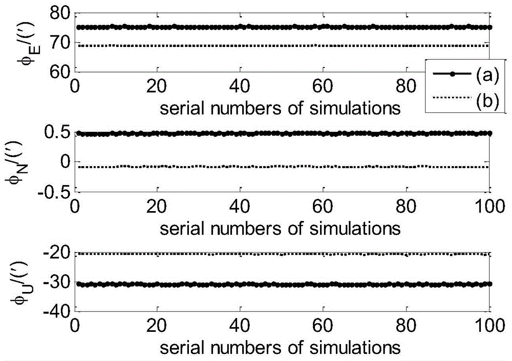
[0024] When the carrier such as a ship is in a small low-frequency swing and oscillation state in practical applications, the carrier attitude matrix is no longer a constant value, in order to solve this problem, the local solidification IMU coordinate system p is introduced 0 To design the corresponding improved analytical coarse alignment.

[0025] Local solidification IMU coordinate system p 0 The definition of is: in the navigation coordinate system (geographical coordinate system), it coincides with the IMU coordinate system at the initial moment, and always remains relatively static with the geographic coordinate system, that is, the coordinate origin coincides with the local geographic coordinate system n, and the direction cosine of the n system The matrix is ​​a constant value, and it is a coordinate system that rotates around the earth-centered inertial coordinate system i synchronously with the n system.

[0026] Averaging of the coarse alignment should be perfor...


PUM


Abstract

The invention provides a rotating modulation-based rocking base inertial navigation system coarse alignment method which can be used for improving the accuracy of coarse alignment in case of a rocking base. The method comprises the following steps: 1, periodically rotating double shafts of a rotary inertial navigation system according to a preset rotation scheme in a coarse alignment process; 2, solving an attitude matrix estimated value of IMU (Inertial Measurement Unit) in each sampling period of the IMU by using an analytic method; 3, performing attitude matrix updating in each sampling period according to angular velocity output by a gyroscope to solve a direction cosine matrix from a local solidification IMU coordinate system to an IMU coordinate system at the current moment; 4, solving an estimated value of the constant direction cosine matrix from the local solidification IMU coordinate system to the IMU coordinate system in the sampling period; 5, solving a final estimated value of the direction cosine matrix from the local solidification IMU coordinate system to the IMU coordinate system; 6, obtaining the attitude matrix of the IMU at the end moment of the coarse alignment.

Description

technical field [0001] The invention belongs to the technical field of strapdown inertial navigation systems, and relates to a rough alignment method for a swing base inertial navigation system based on rotation modulation. Background technique [0002] The initial alignment process of the strapdown inertial navigation system is divided into two stages: coarse alignment and fine alignment. The main task of the coarse alignment is to estimate the approximate value of the attitude matrix, and provide a basic reference mathematical platform for the strapdown inertial navigation system; in the fine alignment stage, the error of the attitude matrix is ​​further estimated by state filtering and other methods, so as to obtain a more accurate mathematical platform, based on which the navigation solution is performed. The accuracy of coarse alignment will affect the convergence speed and accuracy of fine alignment, which in turn affects the accuracy of navigation calculations. There...

Claims


Application Information

Patent Timeline
Patent Type & Authority Patents(China)
IPC IPC(8): G01C25/00
CPCG01C25/005
Inventor 付梦印王博邓志红周元刘彤
Owner BEIJING INSTITUTE OF TECHNOLOGYGY
Why Eureka
Try Eureka