Positioning and tracking method based on video monitor network

A video monitoring and network positioning technology, which is applied in closed-circuit television systems, image data processing, instruments, etc., can solve the problem of few positioning applications, and achieve the effect of fast positioning and tracking

Inactive Publication Date: 2014-04-23
SHENZHEN INST OF ADVANCED TECH
View PDF11 Cites 43 Cited by
  • Summary
  • Abstract
  • Description
  • Claims
  • Application Information

AI Technical Summary

Problems solved by technology

[0003] However, there are relatively few positioning applications based on video surveillance networks, especially precise positioning
The current precise positioning method is mainly through GPS or mobile phone positioning, etc., and this type of method is a passive positioning method, which generally requires the cooperation of the person being positioned.

Method used


Image

  • Positioning and tracking method based on video monitor network
  • Positioning and tracking method based on video monitor network
  • Positioning and tracking method based on video monitor network

Examples


Embodiment Construction

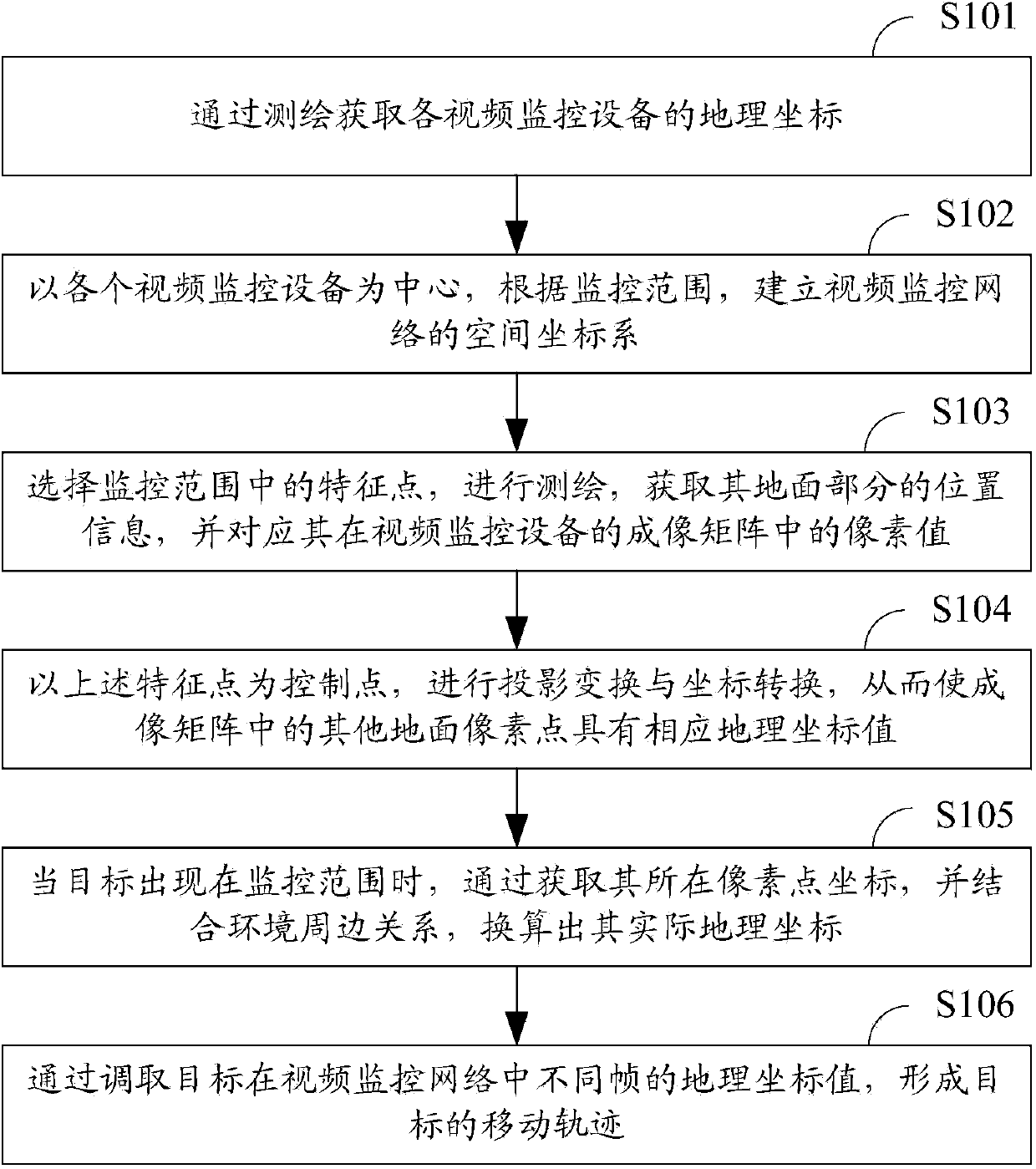
[0022] Such as figure 1 As shown, it is the positioning and tracking method based on the video surveillance network in the present invention, which can actively locate and track the target.

[0023] Specifically, the following steps are included:

[0024] In step S101, the geographic coordinates of each video monitoring device are acquired through surveying and mapping.

[0025] Among them, surveying and mapping instruments include 3D laser scanners, levels, theodolites, total stations, GPS handhelds, super stations, gyroscopes, planimeters, steel rulers, stopwatches, etc. Geographic coordinates mainly refer to longitude and latitude.

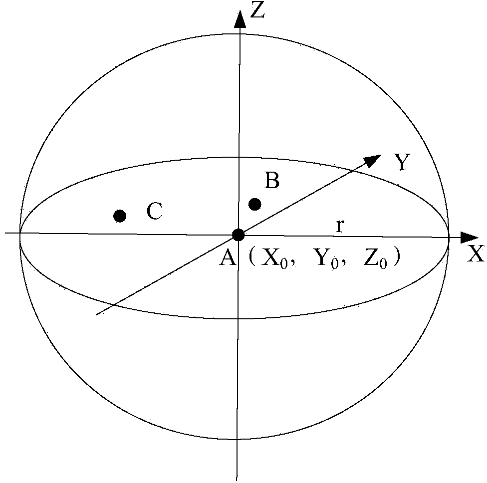
[0026] In step S102, a spatial coordinate system of the video surveillance network is established with each video surveillance device as the center and according to the surveillance range.

[0027] by figure 2 Take the spatial coordinate system of the video surveillance network as an example. For example, the geographic coordinates of vide...


PUM


Abstract

The invention provides a positioning and tracking method based on a video monitor network. The method comprises obtaining geographical coordinates of each video monitor device, establishing a space coordinate system of the video monitor network, with the video monitor device being as the center and according to the monitoring range; selecting a feature point to perform surveying and mapping, and obtaining geographical coordinate of the feature point and corresponding pixel values of the feature point in imaging matrix of the video monitor device; with the feature point being as a control point, carrying out projection conversion and coordinate transformation so as to enable other ground pixel points in the imaging matrix to have corresponding geographical coordinates; when a target appears in the monitoring range, calculating geographical coordinates of the target by obtaining the coordinate of the pixel point where the target lies and combining environment circumference relation; and forming the movement track of the target by taking the geographical coordinates of different frames of the target in the video monitor network. According to the method, the movement track of the target can be positioned and tracked quickly; existing resources of a city is effectively utilized; and more accurate movement route of the target is output.

Description

technical field [0001] The invention relates to the technical field of video surveillance, in particular to a positioning and tracking method based on a video surveillance network. Background technique [0002] Video surveillance network plays an important role in urban security. Dynamic video images contain rich motion information, and the purpose of video image motion analysis is to find out moving targets such as pedestrians and vehicles in video images, and identify the targets , Tracking, this video image motion analysis technology is widely used in video surveillance, intelligent transportation and other fields. [0003] However, there are relatively few positioning applications based on video surveillance networks, especially precise positioning. The current precise positioning method is mainly through GPS or mobile phone positioning, etc., and this type of method is a passive positioning method, which generally requires the cooperation of the person being positioned...

Claims


Application Information

Patent Timeline
Patent Type & Authority Applications(China)
IPC IPC(8): H04N7/18G06T7/20
Inventor 修文群
Owner SHENZHEN INST OF ADVANCED TECH
Why Eureka
Try Eureka