Unlock instant, AI-driven research and patent intelligence for your innovation.

A Node Location and Update Method for Underwater Sensor Networks Based on Time-varying Error Bound

A technology of node positioning and updating methods, which is applied in the direction of network topology, advanced technology, electrical components, etc., to achieve the effects of reducing adverse effects, improving positioning performance, and improving accuracy and reliability

Active Publication Date: 2017-06-09
NAVAL AERONAUTICAL & ASTRONAUTICAL UNIV PLA
View PDF4 Cites 0 Cited by
  • Summary
  • Abstract
  • Description
  • Claims
  • Application Information

AI Technical Summary

Problems solved by technology

[0006] The purpose of the present invention is to provide a node positioning and update method for underwater sensor networks based on time-varying error bounds, to solve the problem of underwater wireless sensor network nodes affected by multi-source unknown noise and time-varying error bounds in complex marine environments Self-location problem; through the online calibration of the error bounds within the positioning group, the adverse effects of multi-source unknown noise on multi-hop distance estimation are reduced, and the accuracy and reliability of position coordinate estimation are improved. The self-adaptive location update of the variable error circle reduces energy consumption, enhances the timeliness of positioning, and improves the positioning performance of underwater sensor networks

Method used


Image

  • A Node Location and Update Method for Underwater Sensor Networks Based on Time-varying Error Bound
  • A Node Location and Update Method for Underwater Sensor Networks Based on Time-varying Error Bound
  • A Node Location and Update Method for Underwater Sensor Networks Based on Time-varying Error Bound

Examples


Embodiment

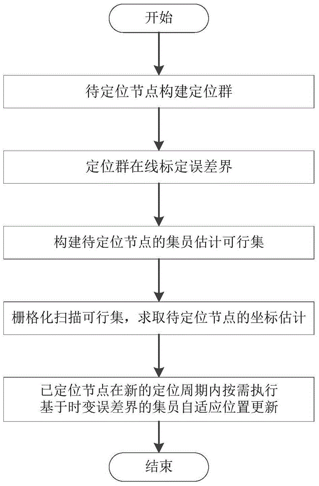
[0088] Such as figure 2 As shown, 400 sensor nodes are randomly deployed in a three-dimensional space area of ​​3000m×3000m×200m, among which the proportion of anchor nodes is 10%, which is represented by a five-pointed star, and the anchor node ID is 1-40; the nodes to be positioned are represented by solid circles , whose IDs range from 41 to 400. The dotted line between the nodes means that two nodes can communicate directly, the communication radius of the nodes is adjustable, and the length of the dotted line represents the Euclidean distance between the two nodes. When the positioning group calibrates the error bound online, the maximum allowable number n of repeated ranging of the anchor node is 5, and the number of resampling B is 200. The granularity of grid scan is one percent of the node communication radius. The measurement noise is non-Gaussian noise that obeys the Rayleigh distribution, and its standard deviation is 2% and 5% of the actual distance, respective...


PUM


Abstract

The invention discloses an underwater sensor network node positioning and updating method based on time varying error bounds, and belongs to the technical field of underwater wireless sensor network positioning. The underwater sensor network node positioning and updating method comprises the steps that firstly, a positioning set is built through nodes to be positioned; secondly, the positioning set calibrates the error bounds on line; thirdly, a set membership estimation feasible set of the nodes to be positioned is built; fourthly, the feasible set is scanned in a grid mode, and coordinates estimation of the nodes to be positioned is solved; fifthly, positioned nods execute set membership self-adaptive position updating based on the time varying error bounds within a new positioning cycle according to needs. Through on-line calibration on the error bounds in the positioning set, adverse effects on multi-hop distance estimation from multi-source unascertained noise is lowered, and accuracy and reliability of position coordinate estimation are improved. As set membership self-adaptive position updating based on the time varying error bounds is executed according to needs, energy consumption is lowered, the timeliness of positioning is increased, and the positioning performance of an underwater sensor network is improved.

Description

technical field [0001] The invention belongs to the technical field of underwater wireless sensor network positioning, in particular to the self-positioning of large-scale underwater wireless sensor network nodes in a complex ocean environment, specifically a method for positioning and updating nodes of an underwater sensor network based on a time-varying error bound . Background technique [0002] Large-scale random deployment in complex ocean environments to perform tasks such as information perception, collection, processing, and transmission is a typical application of Underwater Wireless Sensor Networks, such as naval battlefield situation awareness, marine environment monitoring, and underwater target positioning. tracking etc. Node self-location is a key supporting technology for underwater sensor networks, and it is also a prerequisite for such applications, because the perceived information usually needs to be accompanied by node location information to reflect its...

Claims


Application Information

Patent Timeline
Patent Type & Authority Patents(China)
IPC IPC(8): H04W64/00H04W84/18
CPCY02D30/70
Inventor 任永吉钟建林黄隽刘涛王伟亚辛旭光张丽萍
Owner NAVAL AERONAUTICAL & ASTRONAUTICAL UNIV PLA