A Judgment Method of Whether Key Vehicles Travel According to Specified Routes

A judging method and vehicle technology, applied in the direction of traffic flow detection, etc., can solve the problems of losing supervision ability, unable to judge vehicle driving, etc., and achieve the effect of ensuring the actual situation

Active Publication Date: 2016-08-10
TRAFFIC MANAGEMENT RES INST OF THE MIN OF PUBLIC SECURITY
View PDF5 Cites 0 Cited by
  • Summary
  • Abstract
  • Description
  • Claims
  • Application Information

AI Technical Summary

Problems solved by technology

However, this supervision method requires key vehicles to actively report positioning information through the vehicle-mounted GPS device. For example, in the case of human intervention or the vehicle is not equipped with a vehicle-mounted GPS device, the monitoring center cannot receive positioning information to form a driving route trajectory, so that it is impossible Judging whether the vehicle is driving according to the prescribed route, losing the ability to supervise

Method used


Image

  • A Judgment Method of Whether Key Vehicles Travel According to Specified Routes

Examples


Embodiment Construction

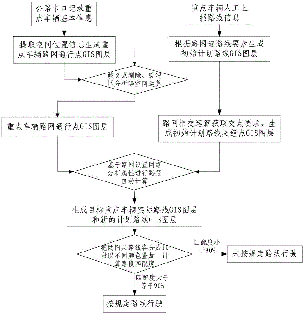
[0017] Such as figure 1 As shown, the present invention includes the following steps.

[0018] 1. Firstly, through the highway bayonet equipment arranged along the road, record the license plate number, license plate type, passing time, recording location, route and other information of each motor vehicle passing through the monitoring area.

[0019] 2. Compare the license plate type, license plate number and road checkpoint traffic information of the target key vehicles, complete the extraction of the checkpoint traffic information of the target key vehicles, generate the traffic record set of the target key vehicles, and generate the road network of the target key vehicles Passing point GIS layer.

[0020] 3. Match the text of the route reported by key vehicles, use the attribute selection tool to filter out the road elements corresponding to the reported route from the road network layer, generate the initial planned route GIS layer, and then use the intersection tool to o...


PUM


Abstract

The invention discloses a method for judging traffic violations of key vehicles that do not travel along prescribed routes, which generates a traffic record set of target key vehicles through highway bayonet equipment; screens out the reported routes corresponding to the reported routes from the road network layer according to the reported routes of key vehicles. Generate the GIS layer of the initial planned route, and then obtain the intersection point to generate the GIS layer of the necessary points of the initial planned route; use the GIS system to display the traffic record set on the map, and establish the automatic calculation of the route after buffer analysis and ambiguity point elimination The process is to generate the GIS layer of the actual route trajectory of the vehicle, and generate a new GIS layer of the planned route from the GIS layer of the necessary points of the initial planned route combined with the spatial topological relationship of the road network; superimposed on the road network dataset with different colors The system automatically judges the matching degree of the planned route GIS layer and the actual route track GIS layer. The invention judges whether the vehicle runs according to the prescribed route by forming the driving trajectory through the bayonet traffic information, without installing GPS equipment.

Description

technical field [0001] The invention relates to the field of road transportation management, in particular to a method for judging whether key vehicles are traveling according to a prescribed route through data analysis of bayonet traffic information. Background technique [0002] The traffic and transportation supervision departments in various places mainly adopt the "two passengers and one dangerous" key vehicle route supervision methods as follows: first, install GPS (Global Positioning System) equipment on key vehicles, and secondly obtain vehicle location and time positioning information in real time through GPS, and then The background system of the monitoring center matches and displays the driving route trajectory on the map, and finally manually compares the route reported by the key vehicles with the driving route trajectory displayed by the system, so as to judge whether the vehicle is driving according to the specified route and time. However, this supervision m...

Claims


Application Information

Patent Timeline
Patent Type & Authority Patents(China)
IPC IPC(8): G08G1/01
Inventor 方艾芬张森缪新顿周建宁孔晨晨
Owner TRAFFIC MANAGEMENT RES INST OF THE MIN OF PUBLIC SECURITY
Why Eureka
Try Eureka