Remote sensing data-based high-precision agricultural region ground surface temperature retrieval method

A technology of surface temperature and remote sensing data, applied in the direction of re-radiation of electromagnetic waves, utilization of re-radiation, measurement devices, etc., can solve the problems of linearization error and unstable effect, and achieve the effect of overcoming the lack of accuracy

Inactive Publication Date: 2015-02-18
NANJING INST OF GEOGRAPHY & LIMNOLOGY
View PDF4 Cites 11 Cited by
  • Summary
  • Abstract
  • Description
  • Claims
  • Application Information

AI Technical Summary

Problems solved by technology

However, the Planck function itself is a complex nonlinear function, and its linearization will inevitably bring certain errors
Technologies such as artificial neural network have also been used in the inversion algorithm of surface temperature (Mao et al., 2008), but the accuracy of neural network algorithm depends heavily on the quality of its learning samples and the setting of its network parameters. The effect is very unstable

Method used


Image

  • Remote sensing data-based high-precision agricultural region ground surface temperature retrieval method
  • Remote sensing data-based high-precision agricultural region ground surface temperature retrieval method
  • Remote sensing data-based high-precision agricultural region ground surface temperature retrieval method

Examples


Embodiment Construction

[0027] In order to better understand the technical content of the present invention, specific embodiments are given together with the attached drawings for description as follows.

[0028]Aspects of the invention are described in this disclosure with reference to the accompanying drawings, which show a number of illustrated embodiments. Embodiments of the present disclosure are not necessarily intended to include all aspects of the invention. It should be understood that the various concepts and embodiments described above, as well as those concepts and embodiments described in more detail below, can be implemented in any of a number of ways, which should be the concepts and embodiments disclosed by the present invention and not Not limited to any implementation. In addition, some aspects of the present disclosure may be used alone or in any suitable combination with other aspects of the present disclosure.

[0029] The present invention carries out high-precision inversion ...


PUM


Abstract

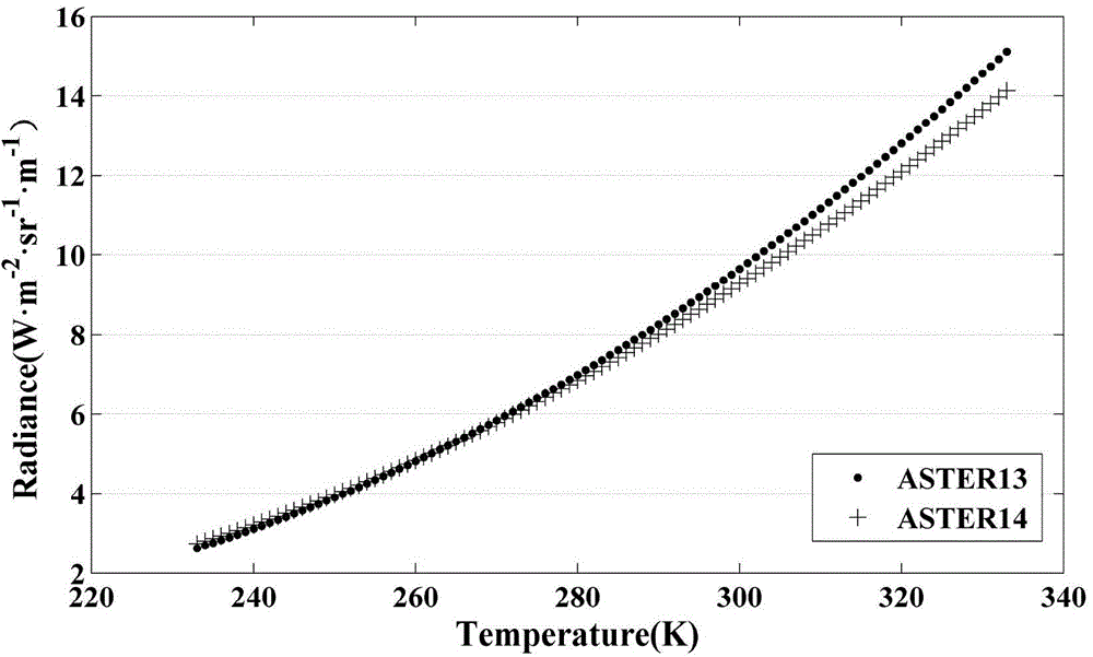
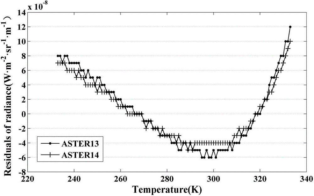
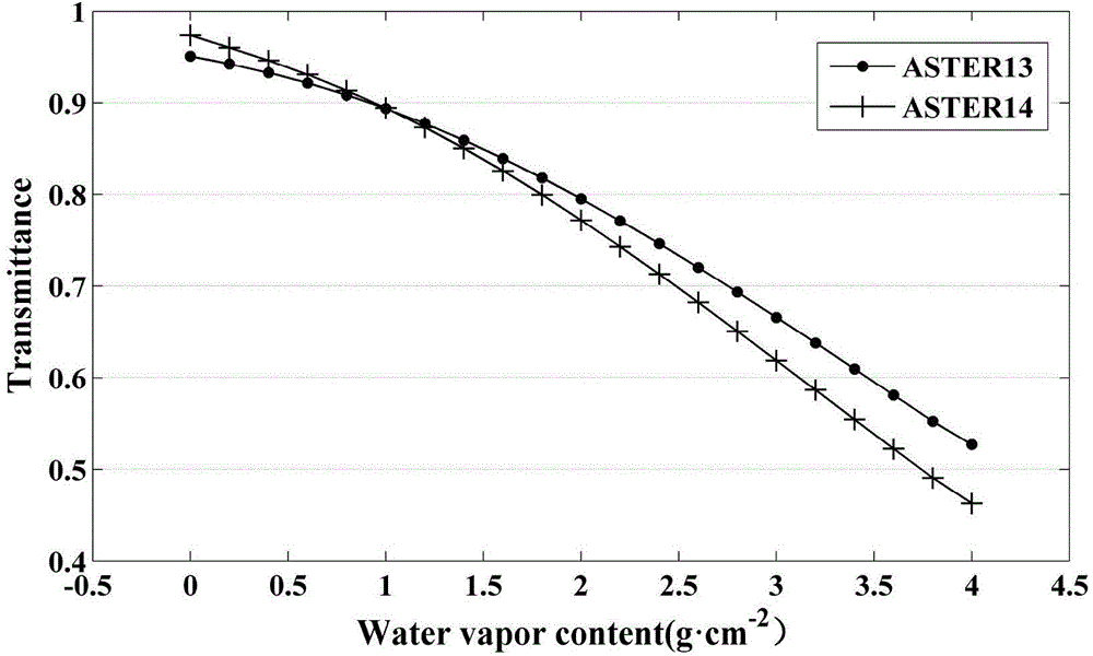
The invention discloses a remote sensing data-based high-precision agricultural region ground surface temperature retrieval method, which comprises the following steps: firstly, calculating relationship between thermal radiation intensity and temperature, and performing non-linear approximation on Planck function by utilizing exponential function; and on the basis, carrying out derivation of a high-precision retrieval method of the ground surface temperature of the agricultural region by combining ground surface thermal radiation transmission equation. According to the method, the ground surface emissivity and atmospheric transmittance are required: NDVI of the ground surface of the agricultural region can be extracted by utilizing the data of ASTER visible light waveband and near infrared waveband so as to further calculate the emissivity data; the content of atmospheric water vapor can be retrieved by utilizing the data of MODIS near infrared waveband, and accurate atmospheric transmittance data can be obtained by fitting the relationship between atmospheric transmittance and the content of atmospheric water vapor through utilizing segmental cubic polynomial fitting. The ground surface temperature of the agricultural region can be accurately obtained, the space-time distribution of the ground surface temperature can be accurately analyzed, the space difference of the regional temperature can be analyzed, thus providing basic data for agriculture, weather, hydrology, ecology, biogeochemistry and the like.

Description

technical field [0001] The invention relates to the field of estimation methods for surface temperature in agricultural areas, in particular to a high-precision inversion method for surface temperature in agricultural areas based on remote sensing data. Background technique [0002] Obtaining surface energy exchange information is an important link in monitoring changes in regional resources and environments. Surface temperature is one of the determinants of surface energy balance. Therefore, it is an important content of the dynamic monitoring of regional resources and environment to obtain the spatial difference of regional surface temperature and then analyze its impact on the change of regional resources and environment. my country's agricultural areas are vast, and obtaining high-precision surface temperature information is conducive to the study of climate, environment, hydrology, ecology, and biochemistry in agricultural areas (Xie et al., 2010; Zhou et al., 2010; Hu...

Claims


Application Information

Patent Timeline
Patent Type & Authority Applications(China)
IPC IPC(8): G01S17/95
CPCG01S17/95Y02A90/10
Inventor 何隆华王松寒
Owner NANJING INST OF GEOGRAPHY & LIMNOLOGY
Why Eureka
Try Eureka