Urban comprehensive emergency command scheduling task distributing system and task distributing method thereof

An emergency command and task technology, applied in the field of comprehensive emergency management, can solve problems such as inability to dispatch tasks, and achieve the effect of high accuracy, strong intelligence, and training of the training team

Inactive Publication Date: 2015-03-11
CLOUD COMPUTING CENT CHINESE ACADEMY OF SCI
View PDF5 Cites 12 Cited by
  • Summary
  • Abstract
  • Description
  • Claims
  • Application Information

AI Technical Summary

Problems solved by technology

[0004] One of the technical problems solved by the present invention is to provide a GIS-based urban comprehensive emergency command and dispatch task dispatching system; to solve the problem that various types of comprehensive emergency command and dispatch systems cannot dispatch tasks through two-dimensional visualization

Method used


Image

  • Urban comprehensive emergency command scheduling task distributing system and task distributing method thereof

Examples


Embodiment Construction

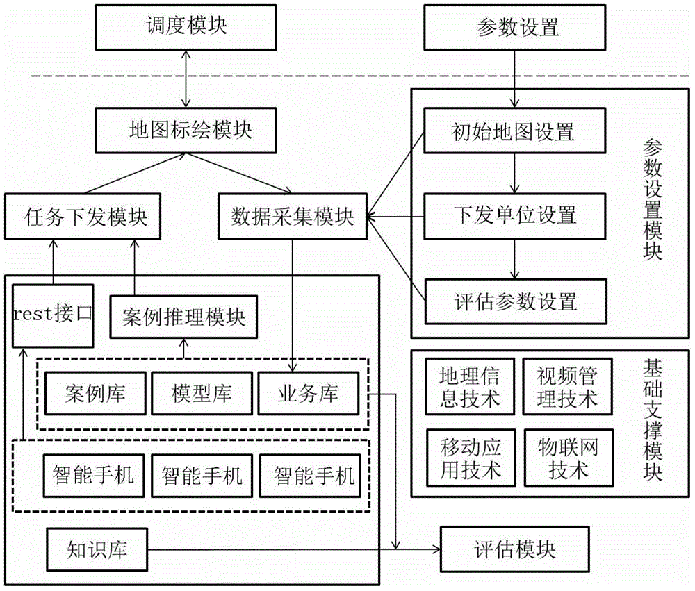
[0025] As shown in the figure, the entire application architecture is divided into four layers, namely the application layer, application support layer, data layer and basic support layer.

[0026] From the perspective of application, the urban comprehensive emergency task dispatching system based on GIS technology mainly includes two parts: command and dispatch and parameter setting.

[0027] The parameter setting is to set the initial start-up conditions for the command and dispatch. The command and dispatch is realized based on the map drawing. After the drawing is completed, it is pushed to the smartphone terminal through the rest api interface.

[0028] Divided from the supporting function modules, the urban comprehensive emergency task dispatch system based on GIS technology mainly includes map drawing module, task delivery module, data acquisition module, case reasoning module, plan execution module, parameter setting module, evaluation module and basic support modules ...


PUM


Abstract

The invention relates to the technical field of comprehensive emergency management, in particular to an urban comprehensive emergency command scheduling task distributing system and a task distributing method thereof. The urban comprehensive emergency command scheduling task distributing system mainly comprises two parts, namely commanding and dispatching and parameter setting; parameter setting is implemented by setting initial starting conditions for commanding and dispatching; the commanding and dispatching are implemented on the basis of map plotting; after plotting is completed, the map is pushed to an intelligent mobile phone through a rest interface. According to the invention, the problems that current tasks distributed by various comprehensive emergency command scheduling systems are not rich in contents and are inaccurate in position are solved; the task distributing method can be used for the emergency command scheduling task distributing system.

Description

technical field [0001] The invention relates to the technical field of comprehensive emergency management, in particular to an urban comprehensive emergency command dispatching task dispatching system and a task dispatching method thereof. Background technique [0002] Geographical information is an important distributed information resource. It has both social benefits and market value. It solves the problems faced by major social sustainable development such as population, resources, environment and disasters; Basic information means for healthy development. Therefore, in the field of geographic information, how to release information so that geographic information system (GIS) can truly serve non-professionals, and the establishment of information sharing technology and open technology is particularly important. [0003] When an emergency occurs, the traditional command and dispatch has changed from the initial direct on-site command and dispatch, to telephone dispatch, ...

Claims


Application Information

Patent Timeline
Patent Type & Authority Applications(China)
IPC IPC(8): G06Q10/06G06Q50/00
CPCG06Q10/063112G06Q50/26
Inventor 贺忠堂马少帅陈焕兴李智勇李新安
Owner CLOUD COMPUTING CENT CHINESE ACADEMY OF SCI
Why Eureka
Try Eureka