Road condition forecast combined path planning method and navigation device

A path planning and navigation device technology, applied in the development and design of navigation technology, can solve the problems of increasing driving complexity, reducing travel time, and increasing travel time

Inactive Publication Date: 2015-04-29
CONTINENTAL HOLDING CHINA CO LTD
View PDF6 Cites 76 Cited by
  • Summary
  • Abstract
  • Description
  • Claims
  • Application Information

AI Technical Summary

Problems solved by technology

Although this can improve the problem of increased travel time due to congestion to a certain extent, the adjustment to route planning due to avoiding congested sections is not the best solution (maybe a long detour), making the total travel time cannot be effectively reduced as a result
In addition, if the traffic information before and after a period of time involves multiple congested road sections, the navigation device will frequently change the route planning in order to avoid the congested road sections. safety hazard due to adjustment

Method used


Image

  • Road condition forecast combined path planning method and navigation device
  • Road condition forecast combined path planning method and navigation device
  • Road condition forecast combined path planning method and navigation device

Examples


Embodiment approach

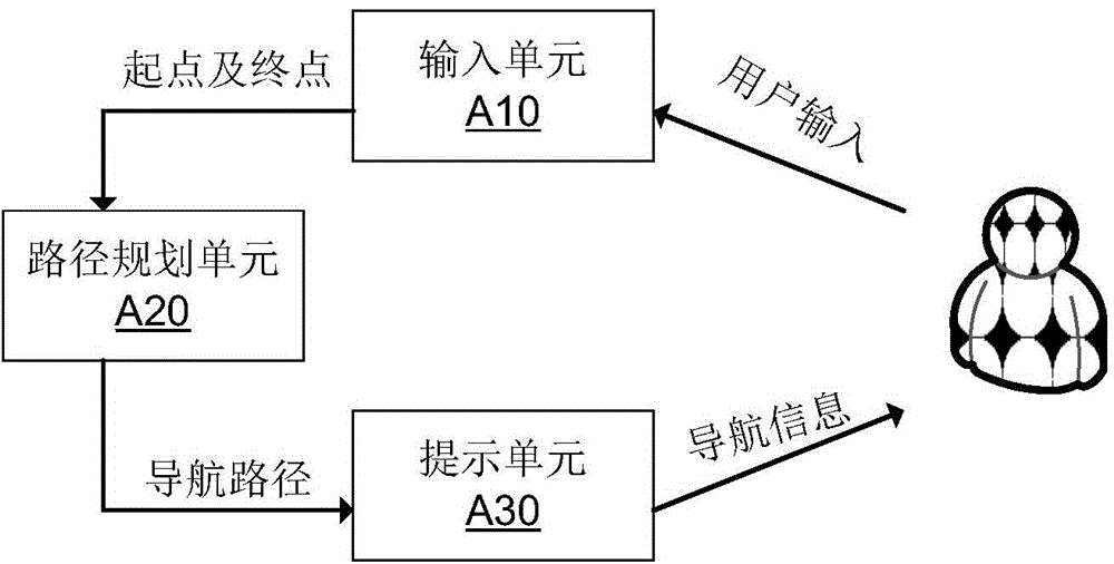
[0030] It can be seen from the benefits of the aforementioned path planning method combined with road condition prediction in the present invention that if this technology is used in a navigation device, it will also make the reference figure 1 As shown, an implementation manner of the navigation device provided by the present invention includes:

[0031] The input unit A10 receives user input to obtain the starting point and end point of this navigation;

[0032] The path planning unit A20 performs path planning by applying the above path planning method;

[0033] The prompt unit A30 prompts the user with navigation information during the navigation process according to the navigation route selected by the user based on the route planning result.

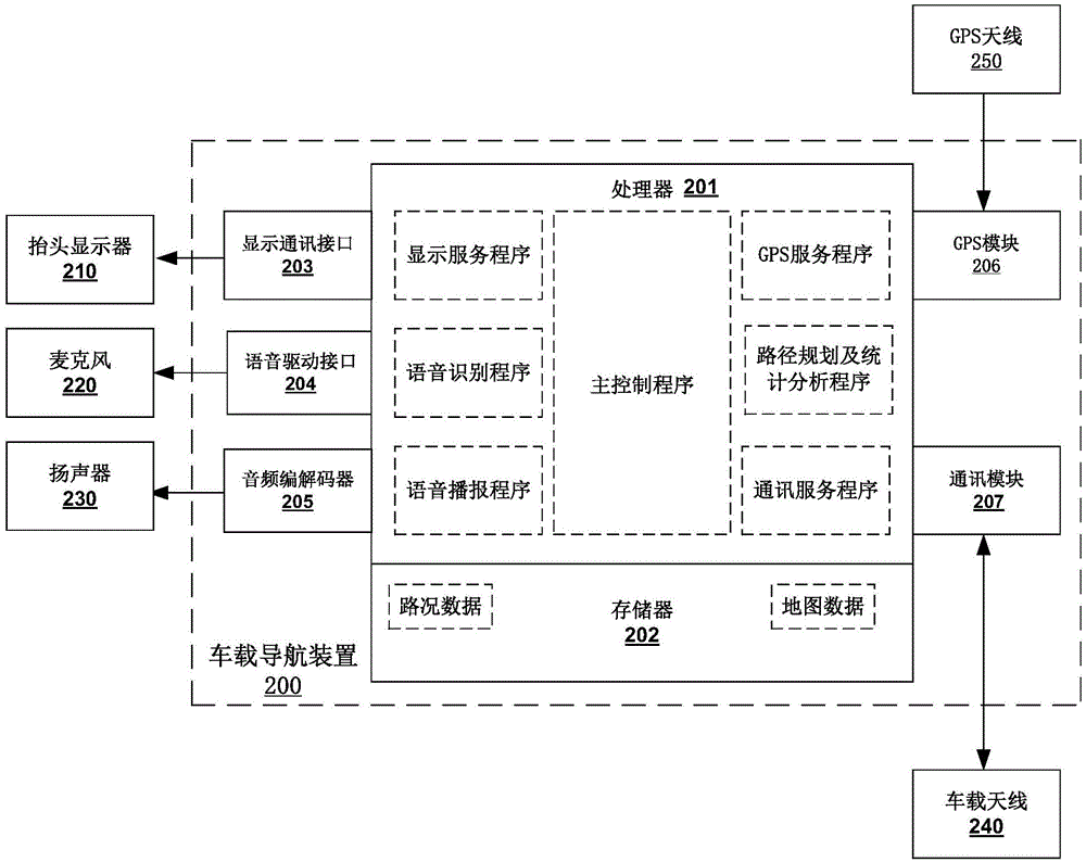
[0034] Wherein, the input unit A10 can provide users with multiple selectable navigation input methods based on the current vehicle electronic technology. In order to realize these input functions in different ways, the input uni...


PUM


Abstract

The invention discloses a traffic data processing method, a road condition forecast combined path planning method and a navigation device. The traffic data processing method comprises steps as follows: historical data of vehicle traveling speeds at one road section in different periods are collected, and road condition data, reflecting historical crowding condition, of the road section are acquired according to the standard vehicle traveling speed of the road section and the obtained vehicle traveling speeds in different periods. The path planning method comprises steps as follows: based on the time starting from the starting point, the vehicle traveling time required from the starting point to a path planning end point through various paths is calculated in combination of the road condition data of each road section in each path. The time calculated through path planning and consumed from the starting point to the end point through one path is the real traveling time of the path historically, so that the calculated traveling time can provide accurate reference for a user and help the user to select a traveling path saving traveling time.

Description

technical field [0001] The invention relates to the development and design of navigation technology, in particular to a path planning method combined with road condition prediction and a navigation device. Background technique [0002] Nowadays, the development of automotive electronic technology makes people more and more dependent on navigation equipment to plan driving routes when traveling. Existing navigation devices usually provide users with multiple driving route planning methods, including: the shortest driving route, the shortest driving time, and the like. Users can choose the appropriate driving route planning method according to their own needs to meet travel needs. [0003] However, most existing navigation devices are based on their fixedly stored navigation data when planning driving routes. And with the promotion of the current urban car ownership, especially in the morning and evening peak hours, road congestion or traffic accidents often occur. However,...

Claims


Application Information

Patent Timeline
Patent Type & Authority Applications(China)
IPC IPC(8): G01C21/34
CPCG01C21/3492
Inventor 金军
Owner CONTINENTAL HOLDING CHINA CO LTD
Why Eureka
Try Eureka