
Parallel construction method of static tile pyramid based on mapreduce

A tile pyramid and construction method technology, which is applied in the fields of electrical digital data processing, digital data information retrieval, instruments, etc., can solve the problems of low resolution, centralized processing mode that is difficult to meet the requirements of remote sensing image processing, and long time consumption

Inactive Publication Date: 2019-01-25
PLA AIR FORCE AVIATION UNIVERSITY
View PDF3 Cites 0 Cited by
  • Summary
  • Abstract
  • Description
  • Claims
  • Application Information

AI Technical Summary

Problems solved by technology

Since resampling is required to generate low-resolution upper-level images when building tile pyramids, the calculation is heavy and time-consuming
With the sharp increase in the amount of remote sensing image data, the centralized processing mode has been difficult to meet the processing requirements of current remote sensing images

Method used


Image

  • Parallel construction method of static tile pyramid based on mapreduce
  • Parallel construction method of static tile pyramid based on mapreduce
  • Parallel construction method of static tile pyramid based on mapreduce

Examples


Embodiment Construction

[0037] The Global Tile Pyramid Model (GTPM) of the present invention has a double-tower quadtree structure, and the image data adopts Plate Carree projection. The east-west tiles on the first level are the root nodes of the two quadtrees. After that, each tile is divided into four points on average to get the next level of tiles, thus obtaining the twin-tower quadtree structure. The tile size is set to 256 pixels × 256 pixels, the top of the pyramid is the first layer, and the number of rows and columns is 1 × 2.

[0038] First Level The number of tile ranks and Level The relationship is: .

[0039] The tiles below the first layer are equally divided by the parent tiles of the upper layer 2×2, so their resolution is half of the tiles of the upper layer. The number of tiles in each layer and the spatial resolution are shown in Table 3.2.

[0040] Table 3.2 Corresponding resolution of each layer of GTPM

[0041] Level

Rows

Number of columns

Resolution (Longitude and Latitud...


PUM


Abstract

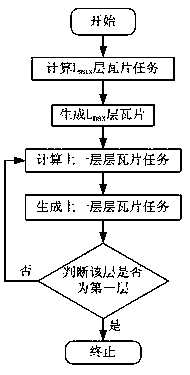
The invention provides a static tile pyramid parallel building method based on MapReduce, and belongs to the technical field of remote sensing image processing. The static tile pyramid parallel building method based on the MapReduce aims at fast performing batch remote sensing image parallel processing on the basis of a parallel calculation model of the MapReduce by aiming at the features of remote sensing images. The method is completed by four steps including Map tile processing, creation of Lmax layers of tiles, tile image generation and Reduce tile merging. The invention provides the improved static tile pyramid parallel building method based on the MapReduce, and the combination of fast parallel building of batch remote sensing image tile pyramid and tile pyramid large file generation is realized. Through structures of tile pyramid large files and HBase tile index tables, a fast retrieval model of global tile images is built.

Description

Technical field [0001] The invention belongs to the technical field of remote sensing image processing. Background technique [0002] The latitude and longitude division grid model is a multi-level grid recursively divided according to the fixed interval of longitude and latitude, which has the advantages of simple, fast and practical. The traditional latitude and longitude mesh model is mainly used to roughly express the spatial position of the earth's surface. Generally, the longitude requirement is not high, and the grid division level is not many. Typical split grid models include NGA's World Geographic Reference System (Georef) and Global Area Reference System (GARS). The above-mentioned split grid model originates from different application backgrounds. It is basically based on the latitude and longitude coordinate system. The split level is generally 3 to 4 levels. Each level has a relatively complete coding system, but it is usually difficult to meet more accurate Geolo...

Claims


Application Information

Patent Timeline
Patent Type & Authority Patents(China)
IPC IPC(8): G06F16/909G06T1/00
Inventor 全吉成吴晨刘宇王宏伟杨明权白新伟李明
Owner PLA AIR FORCE AVIATION UNIVERSITY
Learn More