Realization method for electronic dynamic travel notes
An implementation method and electronic dynamic technology, which are applied in the direction of electronic digital data processing, data processing input/output process, special data processing application, etc., can solve problems such as inability to dynamically manage, and achieve the effect of improving display effect and avoiding proportional imbalance.
- Summary
- Abstract
- Description
- Claims
- Application Information
AI Technical Summary
Problems solved by technology
Method used
Image

Examples
example 1
[0062]For example, in the process of traveling in many places, people use digital devices with geographic location positioning systems, such as GPS, such as mobile phones, to take pictures and obtain a lot of photos, and use these photos to record various customs in the places they pass through during the tour. Favor. The process of how to use these photos to form this electronic dynamic travelogue is as follows:
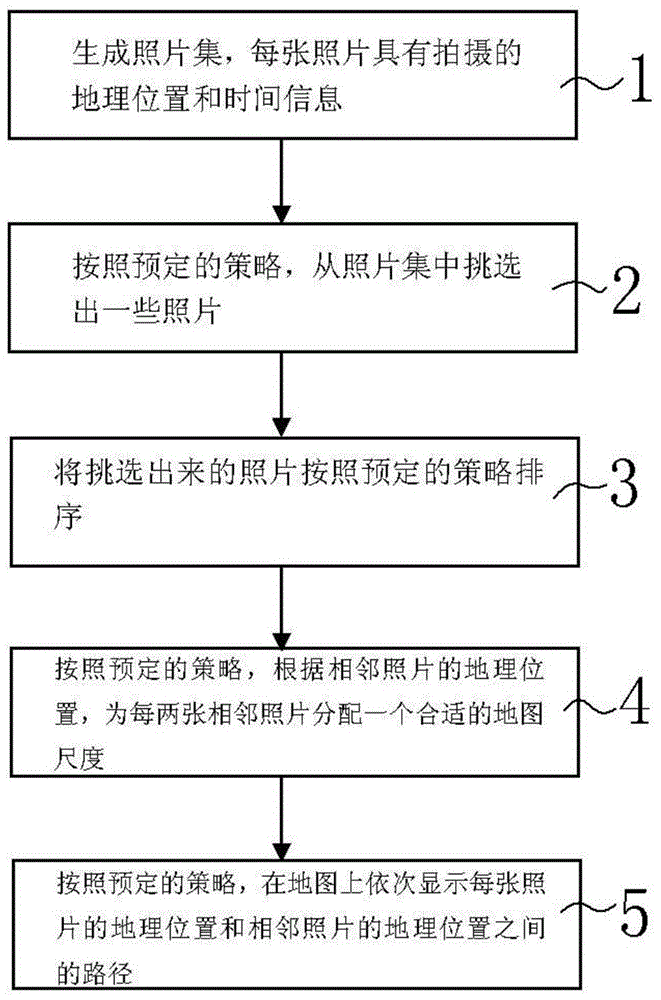
[0063] see figure 1 , which shows the flow chart of the implementation of the dynamic travel note in this example.
[0064] Step 1, firstly collect the photos obtained by shooting to form a corresponding photo set.
[0065] Since the mobile phone used for shooting has the function of geographical location positioning, when taking digital photos, the geographical location information and time information can be obtained by the mobile phone at this time, and embedded in each digital photo taken, for example: recorded in In the EXIF part of each photo, each photo ...
example 2
[0110] This example provides an optimized solution based on the electronic dynamic travel notes implementation solution in Example 1:
[0111] This optimization solution is to display the photos corresponding to the geographical location while sequentially presenting the geographic location and the path between two adjacent points in the form of a map.
[0112] For the display of photos, you can choose to display in a static or dynamic way:
[0113] When displaying static content in the form of a map, such as: a stationary geographic location and a path between two adjacent points, a corresponding photo is displayed at the same time, such as Figure 17 and 19 . This is a static rendering process that can last for a long period of time, for example, 3 seconds.
[0114] When displaying dynamic content in the form of a map, if it is displayed on the map that you are entering a certain geographic location, see Figure 16 and Figure 18 , the corresponding geographic locations...
example 3
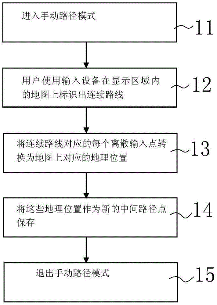
[0120] On the basis of the realization scheme of electronic dynamic travel note in example 1 and example 2, this example provides another way to enhance the trajectory generation method by artificially quickly inputting the trajectory, and realize the path between the address locations of adjacent photos on the map display.
[0121] The method for displaying the paths between the address locations of adjacent photos on the map provided in this example may allow the user to directly designate a certain path with an input device by drawing.
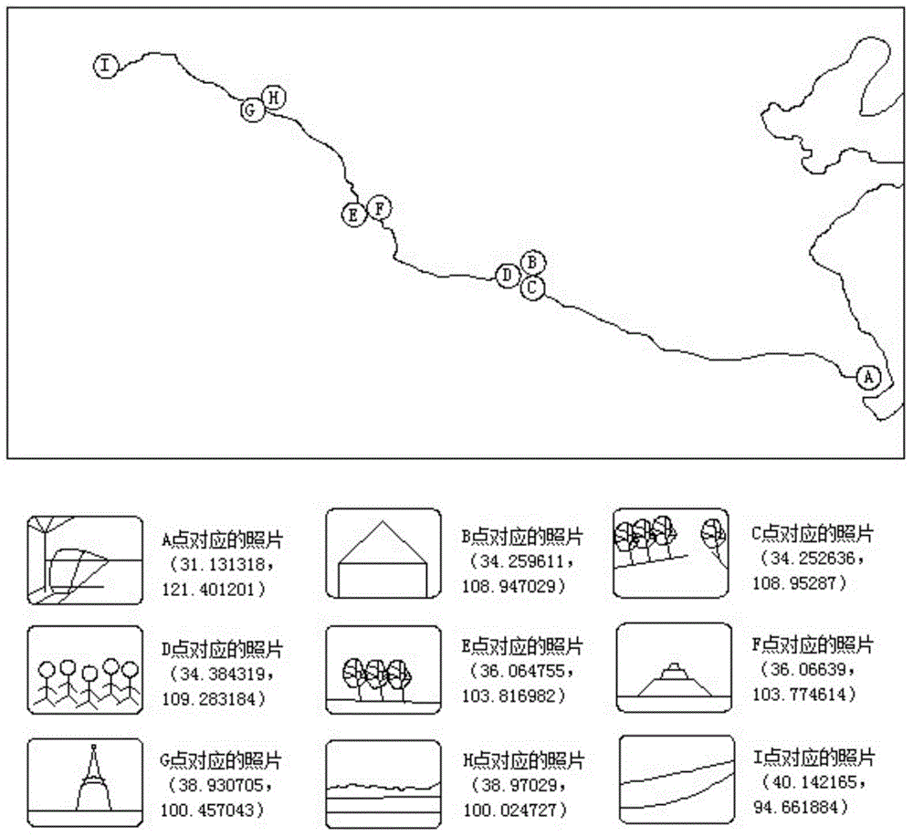
[0122] For example, sometimes the interface provided by the map provider cannot draw a path between specified geographic locations, or the drawn path does not match the actual one, such as Figure 20 As shown, there are three track points A, B, and C in the map shown. Through the interface of the map provider, paths can be drawn between AB, but not between BC. For this situation, you can use the method provided in this example to specify t...
PUM
 Abstract
Description
Claims
Application Information
 - Generate Ideas
- Intellectual Property
- Life Sciences
- Materials
- Tech Scout
- Unparalleled Data Quality
- Higher Quality Content
- 60% Fewer Hallucinations
Browse by: Latest US Patents, China's latest patents, Technical Efficacy Thesaurus, Application Domain, Technology Topic, Popular Technical Reports.
© 2025 PatSnap. All rights reserved.Legal|Privacy policy|Modern Slavery Act Transparency Statement|Sitemap|About US| Contact US: help@patsnap.com