Method for using street level images to enhance automated driving mode for vehicle

A self-driving, street technology, applied in the field of driving experience, that can solve problems such as estimation range limits or constraints

Active Publication Date: 2015-07-29
GM GLOBAL TECH OPERATIONS LLC
View PDF6 Cites 34 Cited by
  • Summary
  • Abstract
  • Description
  • Claims
  • Application Information

AI Technical Summary

Problems solved by technology

The output provided by these on-board devices can provide some information about potential imminent hazards or hazards, but this info

Method used


Image

  • Method for using street level images to enhance automated driving mode for vehicle
  • Method for using street level images to enhance automated driving mode for vehicle
  • Method for using street level images to enhance automated driving mode for vehicle

Examples


Embodiment Construction

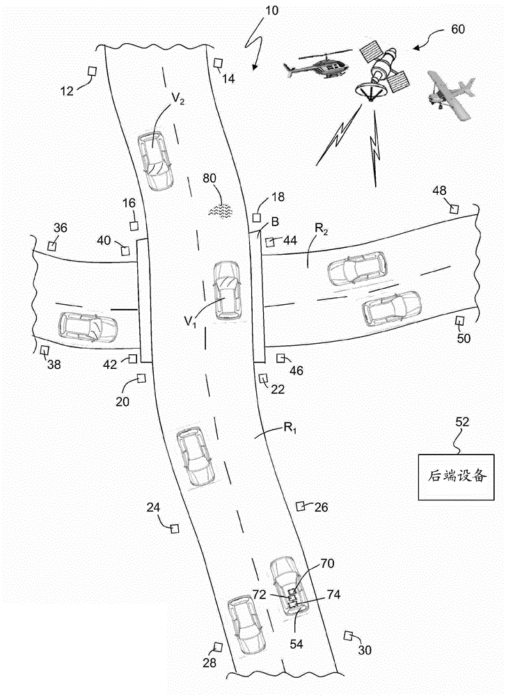
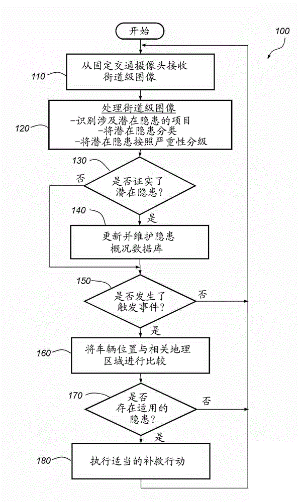
[0043] The systems and methods described herein may enhance the driving experience of a vehicle in autonomous mode by using street-level imagery, such as that provided by stationary or roadside traffic cameras, sensors, or other devices. Many fixed traffic cameras now have high-resolution or high-definition capabilities, which allows them to provide higher-quality still images or video that contain more information. Additional information extracted from street-level imagery allows the system and method to better recognize, identify, classify, and / or assess various hazards or hazards in upcoming road segments, including road segments far ahead and beyond the field of view of on-board equipment . Depending on the type and severity of the hazard or hazard, the present systems and methods can initiate remedial action, such as adjusting the operating parameters of the autopilot mode, deactivating the autopilot mode, or simply alerting the driver of the hazard. Also, additional inf...


PUM


Abstract

A method that utilizes high-definition street level images provided by a network of stationary traffic cameras to identify potential hazards or concerns located beyond the range of vehicle mounted devices, and to provide an advanced warning or to take some other remedial action in response thereto. In one embodiment, the method uses multiple items taken from the street level images to corroborate a potential concern before saving that concern to a concern profile where the concern is linked or otherwise associated with a particular geographic zone. By taking remedial actions well in advance of a potential concern, the method provides more opportunity to adjust or otherwise address the potential concern, which can be particularly advantageous when the host vehicle is being operated in an automated driving mode.

Description

technical field [0001] The present invention relates generally to enhancements to vehicles having an automated driving mode, and more particularly to methods and systems for enhancing the driving experience of an automated driving mode by using street-level imagery, such as images provided by stationary traffic cameras. Background technique [0002] Host vehicles are known to be equipped with object detection capabilities such as on-board cameras, lasers, ultrasound and sensors. These types of devices have a field of view that typically extends some distance in front of the host vehicle and are able to detect the presence of target vehicles and other objects as well as certain features in upcoming road segments. The output provided by these on-board devices can provide some information about potential imminent hazards or hazards, but this information is usually limited or constrained by the field of view, the distance of the device, or the estimated range of the digital map....

Claims


Application Information

Patent Timeline
IPC IPC(8): G08G1/0967B60W40/02
CPCG08G1/166G01C21/34G08G1/165G08G1/164
Inventor J.N.尼科劳乌
Owner GM GLOBAL TECH OPERATIONS LLC
Why Eureka
Try Eureka