Geographical teaching auxiliary system based on geographic information system (GIS)

A geographic information system and teaching aiding technology, applied in the field of geographic teaching aiding systems, can solve the problems that two-dimensional graphics are difficult to interpret knowledge points, reduce students' interest in learning, and teaching materials cannot be carried.

Inactive Publication Date: 2015-09-23
CHUZHOU ZHUANGYUANLANG ELECTRONICS TECH
View PDF3 Cites 1 Cited by
  • Summary
  • Abstract
  • Description
  • Claims
  • Application Information

AI Technical Summary

Problems solved by technology

[0002] At this stage, the teaching courseware of teachers is still mainly based on textbooks, but with the progress of the times, the amount of teaching knowledge is increasing, and simple textbooks can no longer carry it, and it is difficult to use only text and simple two-dimensional graphics. Interpret the knowledge points learned, especially for geography and other subjects, the learning content is highly abstract, such as maps and other teaching tools, simple two-dimensional maps, empty and boring, sometimes not only can not play the role of teaching, sometimes it will reduce students' awareness of subject interest

Method used


Image

  • Geographical teaching auxiliary system based on geographic information system (GIS)

Examples


Embodiment Construction

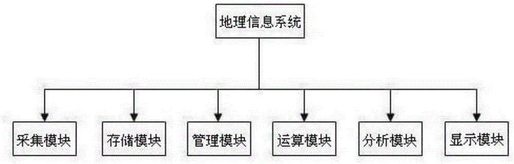
[0006] see figure 1 , the implementation scheme of the present invention is as follows: it includes a geographic information system, and the geographic information system includes an acquisition module, a storage module, a management module, a calculation module, an analysis module, and a display module. The geographic information system can collect, store, manage, calculate, analyze, display and describe the relevant geographical distribution data in the space of the whole or part of the earth's surface (including the atmosphere). , can create and edit map data, realize geographic information data query, statistical analysis and visual display of results, and can show the process of a certain region or feature over time.


PUM


Abstract

A geographical teaching auxiliary system based on a geographic information system (GIS) comprises a geographical information system, and the geographical information system comprises a collecting module, a storage module, a management module, an operation module, an analyzing module and a displaying module. By means of the system, teaching practice activities of the application theory of the GIS system can be achieved, the map data can be made and edited, the query, statistic analysis and results of the geographical information data can be displayed intuitively, and the process that a certain region or a certain ground feature varies along time can be displayed.

Description

Technical field: [0001] The invention relates to the field of educational auxiliary technology, in particular to a geographic teaching auxiliary system based on a geographic information system (GIS). Background technique: [0002] At this stage, the teaching courseware of teachers is still mainly based on textbooks, but with the progress of the times, the amount of teaching knowledge is increasing, and simple textbooks can no longer carry it, and it is difficult to use only text and simple two-dimensional graphics. Interpret the knowledge points learned, especially for geography and other subjects, the learning content is highly abstract, such as maps and other teaching tools, simple two-dimensional maps, empty and boring, sometimes not only can not play the role of teaching, sometimes it will reduce students' awareness of academic interest in the subject. Invention content: [0003] In order to solve the existing problems of the background technology, the present inventi...

Claims


Application Information

Patent Timeline
Patent Type & Authority Applications(China)
IPC IPC(8): G06F17/30G06Q50/20G09B29/00
CPCG06F16/29G06Q50/20G09B29/007
Inventor 蒋智谋谢水兵胡加峰唐骏蒋加佳董子侠李敬龙朱文峰张超
Owner CHUZHOU ZHUANGYUANLANG ELECTRONICS TECH
Why Eureka
Try Eureka