Optimum path selecting method between arbitrary buildings based on city road net structure

A technology of urban road network and optimal path, applied in special data processing applications, instruments, electrical digital data processing, etc., can solve problems that are not considered by algorithms

Inactive Publication Date: 2005-10-19
HUIYANG INFORMATION TECH SHANGHAI
View PDF0 Cites 23 Cited by
  • Summary
  • Abstract
  • Description
  • Claims
  • Application Information

AI Technical Summary

Problems solved by technology

[0005] In addition, the spatial positioning of urban buildings can be easily realized through geographic information system software, but the algorithm for any two points between any buildings has not been considered

Method used


Image

  • Optimum path selecting method between arbitrary buildings based on city road net structure
  • Optimum path selecting method between arbitrary buildings based on city road net structure
  • Optimum path selecting method between arbitrary buildings based on city road net structure

Examples


Embodiment Construction

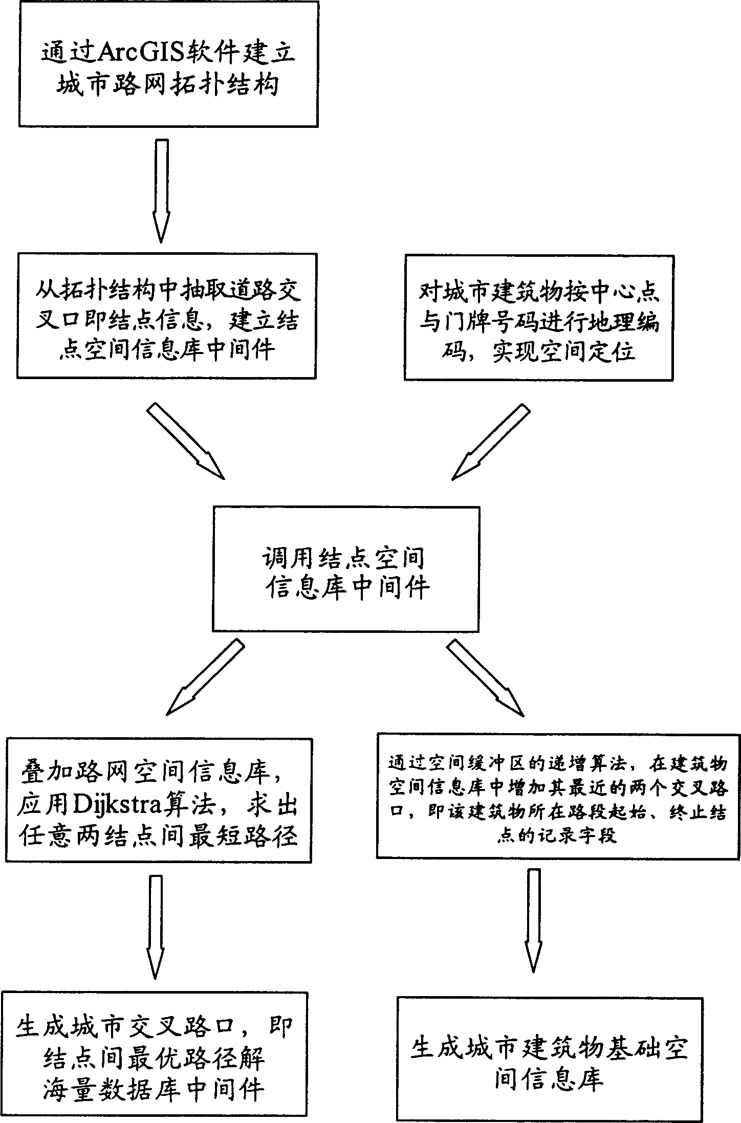
[0055] Basic thought of the present invention is:

[0056] ① Establish the urban road network topology;

[0057] ② Establish road intersections, that is, node layers;

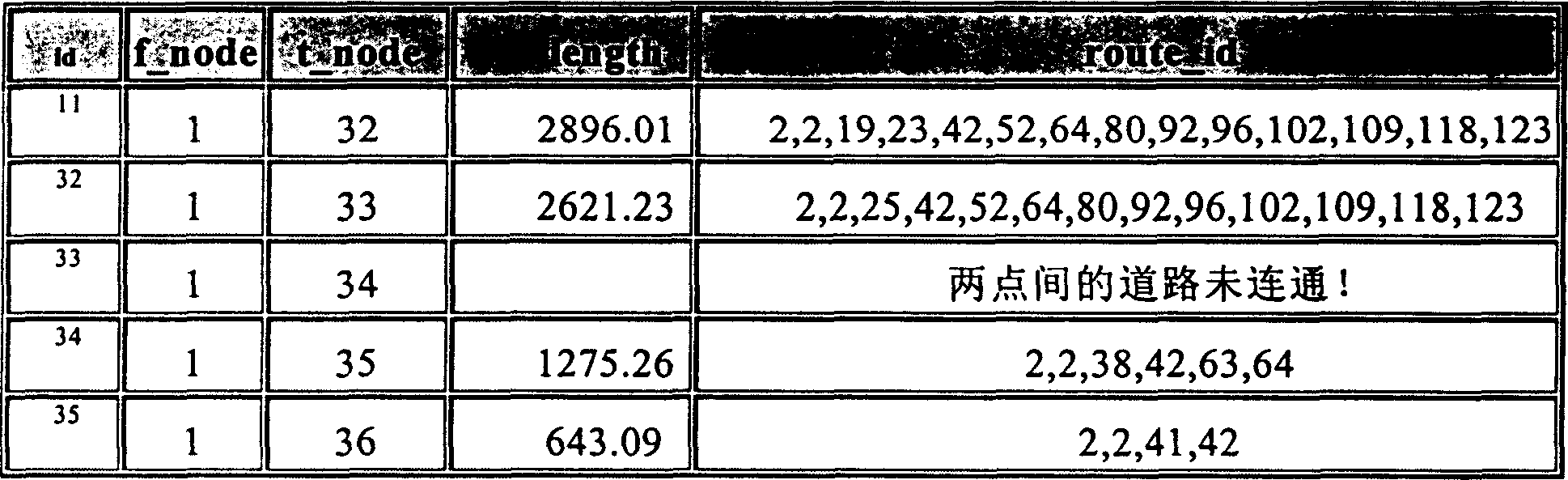
[0058] ③Choose the Dijkstra algorithm to calculate the shortest (optimal) path for all node pairs, and write it into the database V;

[0059] ④Geographically code urban buildings according to house numbers to realize spatial positioning;

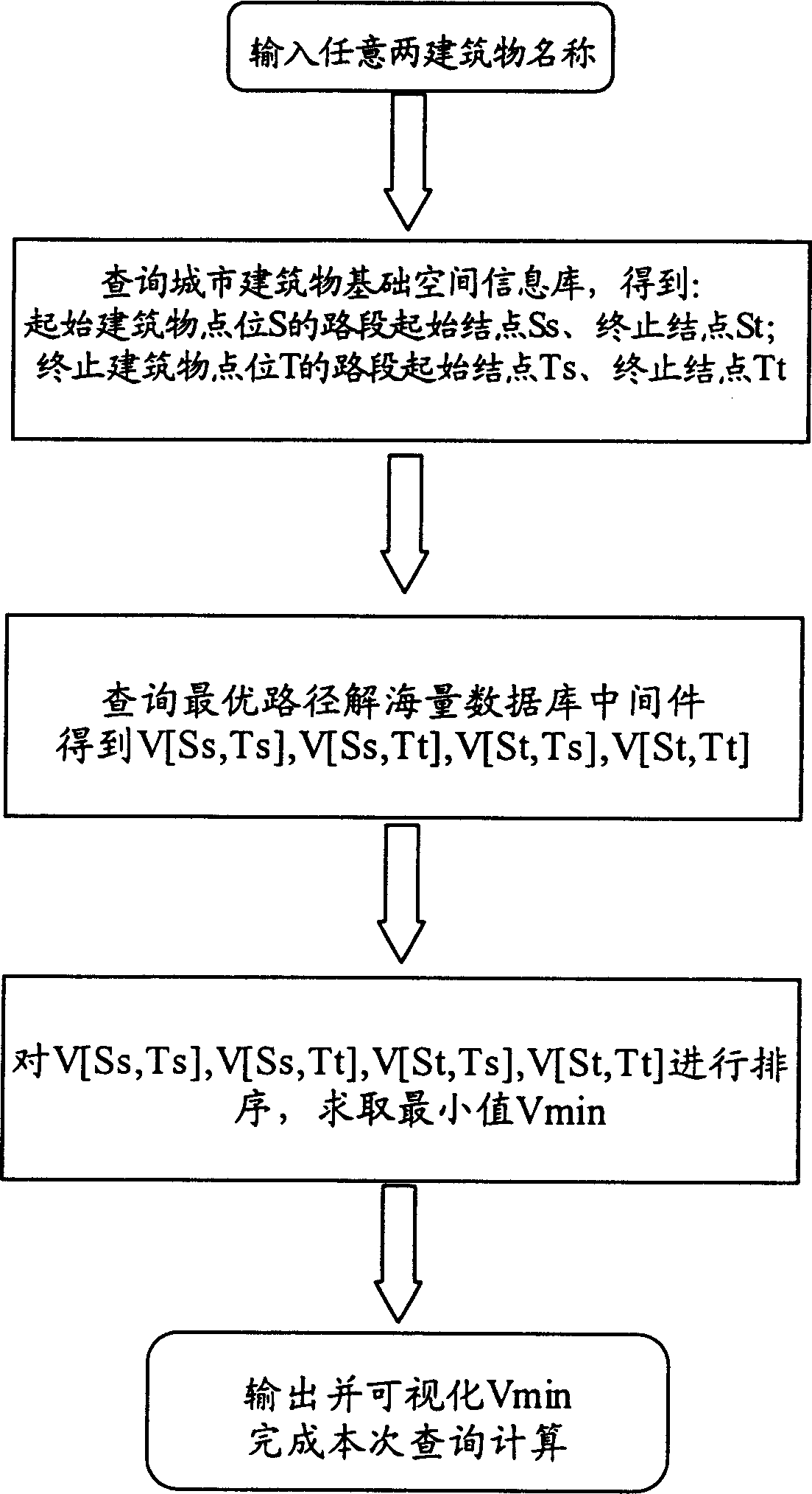
[0060] ⑤ According to the name of the road section 1s where the starting building point S is located, search for the starting node Ss and the ending node St of the road section of the building;

[0061] ⑥ Find the starting node Ts and ending node Tt of the road section of the building according to the name of the road section 1t where the building point T is located;

[0062] ⑦ Find the shortest path W from S to T through the sort calculation of the 4 values ​​after query

[0063] W[S, T]=min{V[Ss, Ts], V[Ss, Tt], V[St, Ts], V[St, Tt]}

[0064] The specific implementatio...


PUM


Abstract

The method of selecting optimal path between two buildings based on city road net structure includes: establishing the topologic structure of city road net; establishing node map layer of road cross points; calculating in Dijkstra algorithm to find all the shortest path between nodes and writing into V database; coding city buildings geographically for spatial locating; searching the initial node Ss and final node St of the initial road section according to the initial site S; searching the initial node Ts and final node Tt of the final road section according to the final site T; sorting and calculating with the four values to find out the shortest path W between S and T W [S, T]=min{V[Ss, Ts], V[Ss, Tt], V[St, Ts], V[St, Tt]}. The present invention converts the optimal path inquiring and calculation process into inquiring process by means of database intermediate technology, and realizes the optimal path inquiry by means of network topologic structure of geographic information system.

Description

technical field [0001] The invention relates to an optimal route selection method between any two points based on the urban road network structure, which can be applied to urban traffic optimal route query, urban logistics and the like. Background technique [0002] At present, open and mature technologies are used for the optimal path algorithm between road network nodes based on geographic information systems at home and abroad, which are mainly reflected in: [0003] ① Establish the urban road network topology; [0004] ②Select the optimal path algorithm to directly calculate the optimal path between nodes. The operation with distance as a parameter is called the shortest path, and the operation combined with the road resistance model is called the optimal path. Regardless of the name, its core The algorithm is a shortest path algorithm based on a directed graph structure. [0005] In addition, the spatial positioning of urban buildings can be realized very conveniently...

Claims


Application Information

Patent Timeline
IPC IPC(8): G06F17/30
Inventor 张超叶雷
Owner HUIYANG INFORMATION TECH SHANGHAI
Why Eureka
Try Eureka