Method and system for integrated navigation of laser inertial measuring unit and odometer

A combined navigation and odometer technology, applied to navigation calculation tools, measuring devices, instruments, etc., can solve problems such as large errors

Active Publication Date: 2015-10-14
THE GENERAL DESIGNING INST OF HUBEI SPACE TECH ACAD
View PDF6 Cites 19 Cited by
  • Summary
  • Abstract
  • Description
  • Claims
  • Application Information

AI Technical Summary

Problems solved by technology

When the laser inertial group is in the oblique state, the angles between the three orthogonal axes and the horizontal plane are all large angles.

Method used


Image

  • Method and system for integrated navigation of laser inertial measuring unit and odometer
  • Method and system for integrated navigation of laser inertial measuring unit and odometer
  • Method and system for integrated navigation of laser inertial measuring unit and odometer

Examples


Embodiment Construction

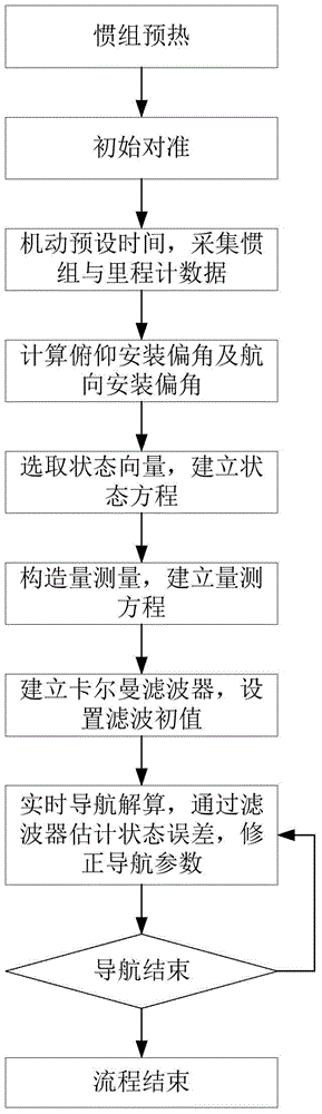
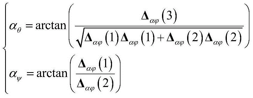
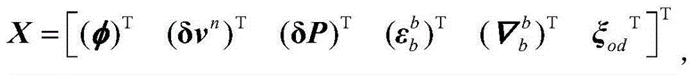
[0026] In order to make the object, technical solution and advantages of the present invention clearer, the present invention will be further described in detail below in conjunction with the accompanying drawings and embodiments. It should be understood that the specific embodiments described here are only used to explain the present invention, not to limit the present invention. In addition, the technical features involved in the various embodiments of the present invention described below can be combined with each other as long as they do not constitute a conflict with each other.

[0027] The inventive method principle is described as follows:

[0028] The odometer is fixedly installed on the car body, connected with the transmission shaft of the vehicle, and transmitted to the odometer cycle rotation through the rotation of the rotating shaft, and the odometer is in the form of pulse N i output, by equivalent K od (Unit: m / pulse) After conversion, the projection of the ...


PUM


Abstract

The invention discloses a method and system for integrated navigation of a laser inertial measuring unit and an odometer. The method comprises steps of: S1, collecting an odometer pulse number in N sampling periods at a normal operation condition, and solving a pitching installation drift angle and a course installation drift angle between the inertial measuring unit and the odometer; S2, establishing a state equation; S3, establishing a measurement equation, which comprises a measurement value 1 shown in the description being a displacement increment of the inertial measuring unit in a No. i sampling period under a navigation system, a measurement value 2 shown in the description being an odometer increment of the inertial measuring unit in the No. i sampling period, and a measurement value 3 shown in the description being a displacement projection of the inertial measuring unit under the navigation system; and S4, utilizing the state equation and the measurement equation, and performing Kalman filtering for correcting parameter errors of an inertial navigation system and a device in real time to complete integrated navigation. The invention further provides a system for realizing the method. By implementing the method and the system, an error of integrated navigation can be effectively corrected, and the accuracy of integrated navigation can be greatly improved. The method and system are particularly suitable for a situation when the inertial measuring unit is inclined at a large angle.

Description

technical field [0001] The invention belongs to the field of inertial combined positioning in the technical field of aerospace strapdown inertial navigation, and more specifically relates to a laser inertial group and odometer combined navigation method and system. Background technique [0002] Strapdown inertial navigation system has the advantages of response time, high reliability, good autonomy and all-weather application. It is widely used in military and civilian navigation fields such as aviation, aerospace and vehicle, and plays an important role in national defense and economic construction. [0003] The inertial navigation system can output information such as the carrier's position, velocity, and attitude in real time, but it is difficult to overcome the shortcomings of the accumulation of navigation errors over time. The odometer is a kind of autonomous distance information measurement sensor. After it is combined with the inertial navigation system, it can suppr...

Claims


Application Information

Patent Timeline
IPC IPC(8): G01C21/20G01C25/00
CPCG01C21/20G01C25/005
Inventor 李旦刘明牟方佳杨道安胡华峰
Owner THE GENERAL DESIGNING INST OF HUBEI SPACE TECH ACAD
Why Eureka
Try Eureka