An Inertial Navigation/Odometer Autonomous Integrated Navigation Method
An integrated navigation and odometer technology, applied in the field of navigation, can solve the problems of large noise in odometer quantification and reducing the accuracy of integrated navigation.
- Summary
- Abstract
- Description
- Claims
- Application Information
AI Technical Summary
Problems solved by technology
Method used
Image
Examples
Embodiment Construction
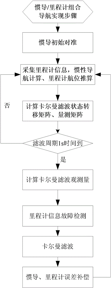
[0078] The following describes the inertial navigation / odometer autonomous integrated navigation method of the present invention in detail with reference to the accompanying drawings and embodiments.
[0079] The coordinate system adopted by the inertial navigation / odometer autonomous integrated navigation method of the present invention is defined as follows:
[0080] n: Navigation coordinate system (oxyz), North Tiandong geographic coordinate system, the x-axis refers to north, the y-axis refers to the sky, and the z-axis refers to the east;
[0081] n′: Calculate the navigation coordinate system (o′x′y′z′), the x′ axis refers to the north, the y′ axis refers to the sky, and the z′ axis refers to the east;
[0082] b: Inertial navigation system (o"x"y"z"), coincides with the gyro coordinate system, the front upper right coordinate system, the x" axis points forward, the y" axis points upward, and the z" axis points right;
[0083] m: Odometer coordinate system (o"'x"'y"'z"'), front up...
PUM
 Abstract
Description
Claims
Application Information
 - R&D
- Intellectual Property
- Life Sciences
- Materials
- Tech Scout
- Unparalleled Data Quality
- Higher Quality Content
- 60% Fewer Hallucinations
Browse by: Latest US Patents, China's latest patents, Technical Efficacy Thesaurus, Application Domain, Technology Topic, Popular Technical Reports.
© 2025 PatSnap. All rights reserved.Legal|Privacy policy|Modern Slavery Act Transparency Statement|Sitemap|About US| Contact US: help@patsnap.com


