Inertial navigation/mileometer autonomous integrated navigation method

An integrated navigation and odometer technology, applied in the field of navigation, can solve the problems of reducing the accuracy of integrated navigation and large noise of odometer quantification.

Active Publication Date: 2013-07-24
BEIJING AUTOMATION CONTROL EQUIP INST
View PDF3 Cites 48 Cited by
  • Summary
  • Abstract
  • Description
  • Claims
  • Application Information

AI Technical Summary

Problems solved by technology

[0004] The technical problem to be solved by the present invention is: in the existing inertial navigation/odometer inte

Method used


Image

  • Inertial navigation/mileometer autonomous integrated navigation method
  • Inertial navigation/mileometer autonomous integrated navigation method
  • Inertial navigation/mileometer autonomous integrated navigation method

Examples


Embodiment Construction

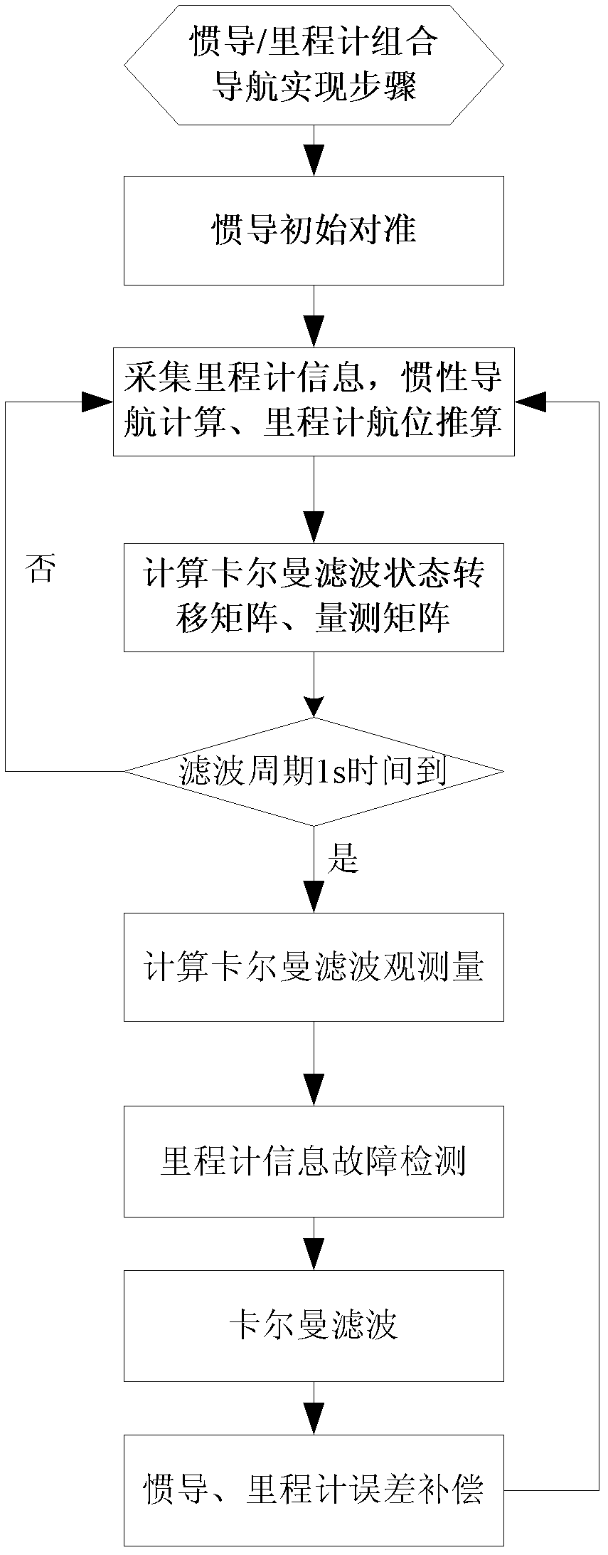
[0078] The inertial navigation / odometer autonomous integrated navigation method of the present invention will be described in detail below in conjunction with the accompanying drawings and embodiments.

[0079] The coordinate system adopted by the inertial navigation / odometer autonomous integrated navigation method of the present invention is defined as follows:

[0080] n: navigation coordinate system (oxyz), Beitiandong geographical coordinate system, x-axis refers to north, y-axis refers to sky, z-axis refers to east;

[0081] n': calculate the navigation coordinate system (o'x'y'z'), the x' axis points to the north, the y' axis points to the sky, and the z' axis points to the east;

[0082] b: Inertial navigation carrier system (o″x″y″z″), which coincides with the gyro coordinate system, the front upper right coordinate system, the x″ axis points forward, the y″ axis points up, and the z″ axis points to the right;

[0083] m: odometer coordinate system (o″′x″′y″′z″′), fro...


PUM


Abstract

The invention belongs to the technical field of navigation, and concretely relates to an inertial navigation/mileometer autonomous integrated navigation method. The method comprises the following steps: 1, initially aligning an inertial navigation system, and initializing parameters of a Kalman filter; 2, carrying out inertial navigation calculation to obtain a discrete state transfer matrix and a measurement matrix; 3, calculating based on the summation measurement of displacement errors to obtain a filtering observation; 4, carrying out mileometer information fault detection; 5, carrying out Kalman filtering; and 6, correcting. The method solves technical problems of too large mileometer quantification noise and reduced combination navigation precision of present inertial navigation/mileometer integrated navigation methods; and the method which adopts a displacement integration coupling based inertial navigation/mileometer integrated navigation strategy abandons a quantization noise introduced in the traditional methods utilizing a speed, which is obtained by performing calculation on a displacement, as an observation, and substantially improves the reliability of an integrated navigation system.

Description

technical field [0001] The invention belongs to the technical field of navigation, and in particular relates to an inertial navigation / odometer autonomous combined navigation method. Background technique [0002] In the field of land positioning and orientation applications, there is an urgent demand for high-precision vehicle positioning and orientation systems at home and abroad. Among them, the integrated navigation of inertial navigation system, GNSS and odometer is a method commonly used in land positioning and orientation systems. However, because GNSS information is susceptible to interference, the main working mode adopted by typical land positioning and orientation system products at home and abroad is inertial navigation / odometer integrated navigation, which is compatible with zero-speed correction technology to obtain high positioning and orientation accuracy, and have full autonomy. [0003] At present, the inertial navigation / odometer integrated navigation gen...

Claims


Application Information

Patent Timeline
IPC IPC(8): G01C21/20G01C22/00
Inventor 吴亮华郑辛李群蔡善军石志兴马二杰朱红
Owner BEIJING AUTOMATION CONTROL EQUIP INST
Why Eureka
Try Eureka