Baseband signal processing method used for GPS satellite navigation

A baseband signal processing and satellite navigation technology, applied in the field of GPS satellite signal processing, can solve the problem of insufficient precision and achieve the effects of high carrier phase precision, improved reliability, and accelerated convergence speed

Inactive Publication Date: 2016-01-27
SHANGHAI HUACE NAVIGATION TECH
View PDF4 Cites 24 Cited by
  • Summary
  • Abstract
  • Description
  • Claims
  • Application Information

AI Technical Summary

Problems solved by technology

[0003] For ordinary navigation receivers, the accuracy of the original measurement value obtained from the tracking loop is not high enough, the ac...

Method used


Image

  • Baseband signal processing method used for GPS satellite navigation
  • Baseband signal processing method used for GPS satellite navigation
  • Baseband signal processing method used for GPS satellite navigation

Examples


Embodiment Construction

[0029] The following will clearly and completely describe the technical solutions in the embodiments of the present invention with reference to the accompanying drawings in the embodiments of the present invention. Obviously, the described embodiments are only some, not all, embodiments of the present invention. Based on the embodiments of the present invention, all other embodiments obtained by persons of ordinary skill in the art without making creative efforts belong to the protection scope of the present invention.

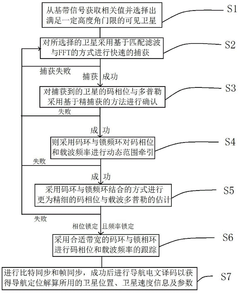
[0030] Such as figure 1 , figure 2 and image 3 Shown, a kind of baseband signal processing method for GPS satellite navigation, described baseband signal processing method for GPS satellite navigation comprises the following steps:

[0031] Step S1: Obtain correlation values ​​from baseband signals and select visible satellites that meet a certain altitude threshold;

[0032] The specific implementation of the step S1 is to obtain the correlation value fr...


PUM


Abstract

The present invention discloses a baseband signal processing method used for GPS satellite navigation. The method comprises rapidly capturing a selected satellite by using a method based on matched filtering and an FFT, thus to obtain code phase and Doppler information under large range uncertainty; confirming the code phase and Doppler information of the captured satellite by adopting a method based on fine capture; carrying out dynamic range traction on a code phase and a carrier frequency by adopting a code loop and a frequency-locked loop; tracking the code phase and the carrier frequency by adopting the code loop and the frequency-locked loop of proper bandwidths; and carrying out bit synchronization and frame synchronization, and carrying out navigation message decoding after success, thus to obtain satellite position and speed informaton and parameters used by navigational positioning calculation. With adoption of the baseband signal processing method used for GPS satellite navigation, high-quality raw observed quantities of a pseudorange and a carrier phase can be output, the precision of the pseudorange and the carrier phase is raised, and the reliability is also raised.

Description

technical field [0001] The invention relates to the field of GPS satellite signal processing, in particular to a baseband signal processing method for GPS satellite navigation. Background technique [0002] The satellite navigation receiver searches and captures each visible satellite signal from the received satellite signal, obtains the rough code phase value and carrier Doppler value of the captured satellite signal, and then the captured satellite is sent to the idle tracking channel for satellite tracking. Signal tracking. Since the acquisition can only roughly estimate the carrier Doppler value and the code phase parameter value, the purpose of tracking is to refine the estimated value of these parameters and keep track of these parameters, and then demodulate them from the tracked satellite signal Navigation message, and extract the original pseudo-range measurement value from the code tracking loop, and extract the original carrier phase measurement value from the c...

Claims


Application Information

Patent Timeline
IPC IPC(8): G01S19/37
Inventor 王超汪利王清亮唐尔辉
Owner SHANGHAI HUACE NAVIGATION TECH
Why Eureka
Try Eureka