Vessel navigation aiding facility data automatic extraction method based on S-57 sea chart

A S-57, automatic extraction technology, applied in the application field of ship traffic management system, can solve the problems of scattered VTS users' attention to ships, poor display effect, inconsistency of map display data calculation and application data, etc., to solve the problem of data capping, Ensure consistent effect

Active Publication Date: 2016-02-10
THE 28TH RES INST OF CHINA ELECTRONICS TECH GROUP CORP
View PDF9 Cites 2 Cited by
  • Summary
  • Abstract
  • Description
  • Claims
  • Application Information

AI Technical Summary

Problems solved by technology

[0005] 2. The displayed content does not match the actual application data;
[0006] The display system of the Vessel Traffic Management System uses S-57 charts or other maps to display, but the data used for alarm resolution, navigation aid services and traffic organization are manually entered into the database, which is different from the charts on S-57 charts. The content sources are different, and there is no matching, and there is a problem that the map display data is inconsistent with the background calculation application data
[0007] 3. The target display is incomplete;
In addition, the S-57 chart shows the data of the ship's navigation aids too prominently, which will greatly distract VTS users from paying attention to the ship
[0009] 4. Poor three-dimensional display effect;
[0010] At present, the application of S-57 charts in 3D display is relatively small. In order to display navigation environment data in 3D maps, it is generally displayed in the form of feature layers, that is, after the two-dimensional display content of S-57 charts is rasterized. Automatically calibrated to the three-dimensional coordinate space, the display effect of this method is poor, and the data display and concealment of the S-57 chart cannot be controlled

Method used


Image

  • Vessel navigation aiding facility data automatic extraction method based on S-57 sea chart
  • Vessel navigation aiding facility data automatic extraction method based on S-57 sea chart
  • Vessel navigation aiding facility data automatic extraction method based on S-57 sea chart

Examples


Embodiment Construction

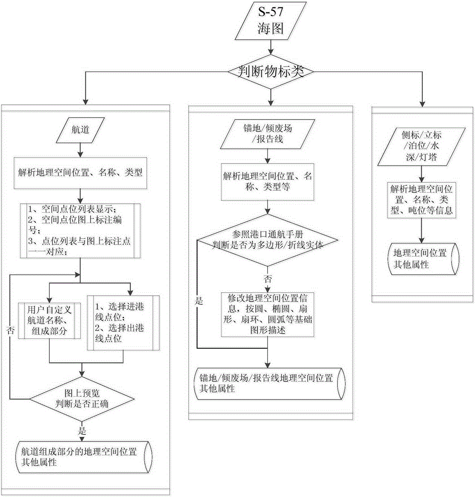
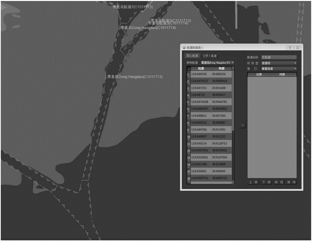
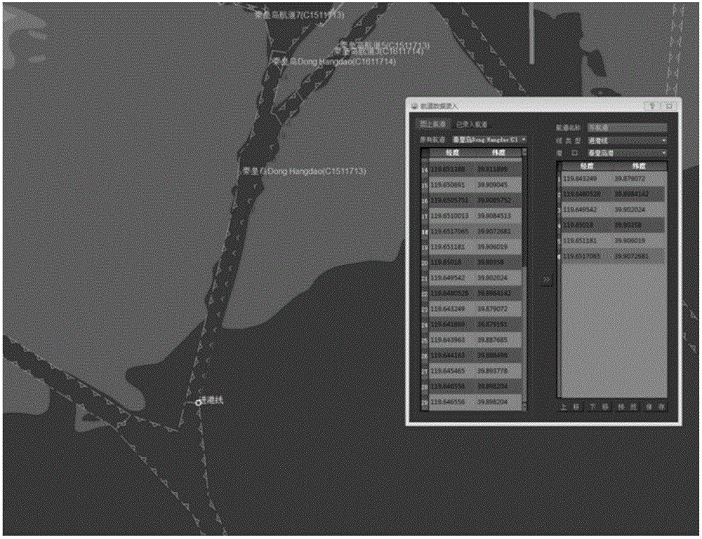
[0029] The application of ship navigation aid data in the ship traffic management system of the present invention mainly includes three aspects: the first is 2D and 3D display and control. It can also use the water depth data to construct the real terrain of the port; the second is the alarm calculation. When calculating the ship alarm, the ship traffic management system needs the geographical location of static targets such as anchorage, channel, berth, water depth, buoys, and erecting markers to provide for the normal navigation of the ship. Provide guarantee; the third is the navigation aid service, prompting the nearest anchorage to the ship, the water depth near the ship and other services need to be calculated based on the data of the ship's navigation aid facilities.

[0030] In the data of ship navigation aids, the geographic objects of "point" objects such as buoys, buoys, berths, water depths, and lighthouses (the S-57 standard classifies actual geographic objects as ...


PUM


Abstract

The present invention discloses a vessel navigation aiding facility data automatic extraction method based on an S-57 sea chart. The method comprises the following steps of: Step 1: inputting vessel navigation aiding facility data in an interactive channel input manner; Step 2: inputting a target with a special shape in a manual input manner; and step 3: automatically extracting point data of a buoy, a beacon and a lighthouse. The vessel navigation aiding facility data automatic extraction method based on the S-57 sea chart, disclosed by the present invention, solves the problem of difficulty in extracting vessel navigation aiding facility data of a vessel traffic management system (VTS). According to the vessel navigation aiding facility data automatic extraction method, based on the vessel navigation aiding facility data such as a channel, anchorage ground, the buoy and the like contained in the S-57 sea chart, in combination with specific requirements of the VTS on the vessel navigation aiding facility data, the vessel navigation aiding facility data are automatically extracted, so that the acquisition, loading and management efficiency of vessel navigation environment data are improved, and the vessel navigation environmental data consistency in two-dimensional and three-dimensional display is guaranteed.

Description

technical field [0001] The invention relates to an application field of a vessel traffic management system (VTS), in particular to a method for automatically extracting data of ship navigation aids based on the S-57 chart according to the S-57 data standard and the special display requirements of the vessel traffic management system. Background technique [0002] S-57 is an electronic chart data transmission standard formulated by the International Hydrographic Organization, which stipulates how the electronic chart data should be stored and transmitted in a structured manner, and the display method of the data is stipulated by the S-52 standard. The standardized data structure and display style of the S-57 chart enhances the potential commercial value of the VTS system. VTS pursues the development of informatization and intelligence, and the requirements for the data of ship navigation aids are becoming more and more complex. With the continuous development of port trade, ...

Claims


Application Information

Patent Timeline
Patent Type & Authority Applications(China)
IPC IPC(8): G06F17/30
CPCG06F16/29
Inventor 李小欢王君韩晓宁陈梦冉丁康隋远
Owner THE 28TH RES INST OF CHINA ELECTRONICS TECH GROUP CORP
Why Eureka
Try Eureka