WSN coverage blind zone detection method based on three-dimensional terrain correction

A technology covering blind areas and three-dimensional terrain, applied in electrical components, wireless communication, network topology, etc., can solve the problem of unsuitable terrain surface with large fluctuations

Inactive Publication Date: 2016-03-09
GUILIN UNIVERSITY OF TECHNOLOGY
View PDF4 Cites 18 Cited by
  • Summary
  • Abstract
  • Description
  • Claims
  • Application Information

AI Technical Summary

Problems solved by technology

[0006] The purpose of the present invention is to provide a WSN coverage blind spot detection method based on three-dimensional terrain correction, which solves the problem that the prior art can detect coverage blind spots, which are almost all realized in a two-dimensional plane, and are not suitable for terrain surfaces with large ups and downs.

Method used


Image

  • WSN coverage blind zone detection method based on three-dimensional terrain correction
  • WSN coverage blind zone detection method based on three-dimensional terrain correction
  • WSN coverage blind zone detection method based on three-dimensional terrain correction

Examples


Embodiment Construction

[0046] The present invention will be described in detail below in combination with specific embodiments.

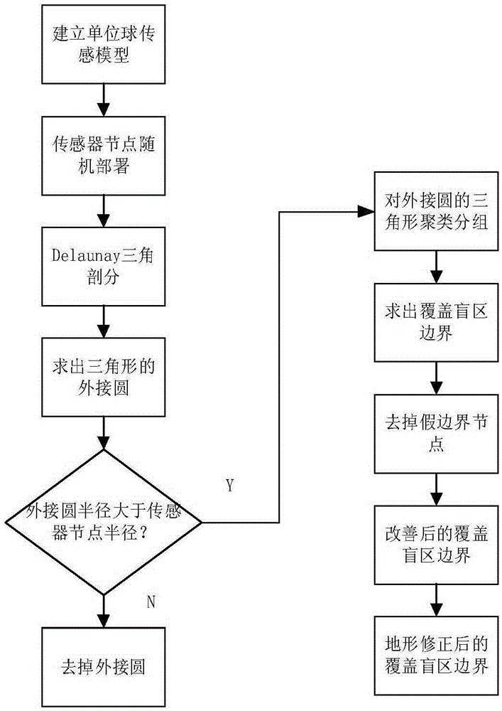
[0047] Aiming at a three-dimensional topographical surface with large undulations, the present invention uses a WSN coverage blind spot detection method based on three-dimensional topography correction to effectively detect the coverage blind spot in a target area. The method of the present invention is as figure 1 shown. Specific steps are as follows:

[0048] (1) Establish a unit ball perception model

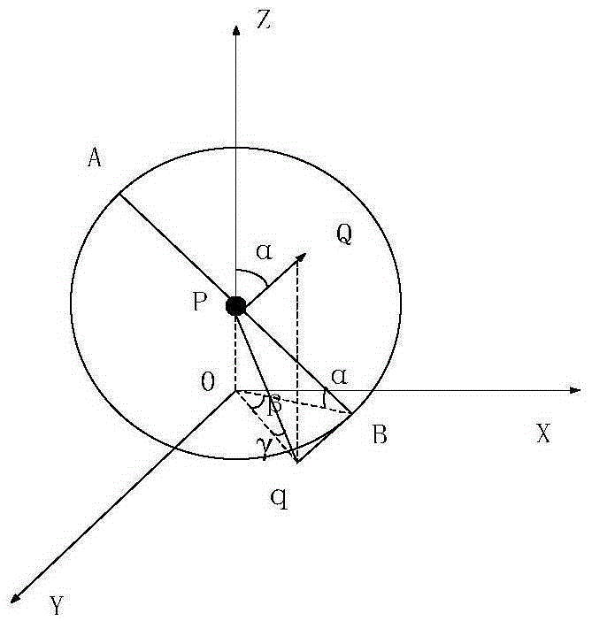
[0049] Assumption: the target area is a convex surface M of the three-dimensional space class, M can be expressed as a single-valued function z=h(x, y) in the Cartesian product coordinate system, if and only if the function is z=c, c is When constant, M is a plane. A sensor is placed in the target area M, when the coordinates of the sensor satisfy the equation of the target area M, then s i ∈M,s i is the sensor location. The present invention adopts a unit sphere ...


PUM


Abstract

The invention discloses a WSN coverage blind zone detection method based on three-dimensional terrain correction. The WSN coverage blind zone detection method comprises the steps of: deploying sensor nodes in a target region randomly, and carrying out Delaunay triangular subdivision; drawing a circumcircle of each Delaunay triangle, and showing boundary of a coverage blind zone through adopting a minimum polygon capable of containing the coverage blind zone; judging false boundary nodes among the boundary nodes, and showing the improved coverage blind zone boundary through adopting a minimum polygon capable of containing the coverage blind zone again after removing the false boundary nodes; and calculating an actual detection radius by utilizing a slope and a slope aspect angle, and finally calculating the corrected coverage blind zone boundary by using a detection algorithm. The WSN coverage blind zone detection method has the beneficial effects that the detection algorithm of the coverage blind zone can be applied to terrain surface with large fluctuation.

Description

technical field [0001] The invention belongs to the technical field of wireless measurement, and relates to a WSN coverage blind area detection method based on three-dimensional terrain correction. Background technique [0002] Wireless Sensor Network (Wireless Sensor Network, WSN) is a network system formed by a large number of cheap micro sensor nodes randomly deployed in a certain area that needs to be monitored, and self-organized through wireless communication. Coverage performance is a key indicator to measure the service quality of WSN. Continuously improving and improving coverage performance has become the main focus of research in recent years, and the repair of coverage holes (or holes) is an important research content. In the target area, the sensor nodes are randomly deployed, resulting in no sensor nodes in some monitoring areas, resulting in coverage blind spots, which seriously affect the performance of the network. In addition, with the operation of the net...

Claims


Application Information

Patent Timeline
Patent Type & Authority Applications(China)
IPC IPC(8): H04W16/18H04W16/26H04W24/02H04W84/18
Inventor 神显豪李军
Owner GUILIN UNIVERSITY OF TECHNOLOGY
Why Eureka
Try Eureka