Eureka AIR delivers breakthrough ideas for toughest innovation challenges, trusted by R&D personnel around the world.

GIS based streetlight resource device intelligent display system and method

A display system and street lamp technology, applied in structured data retrieval, instruments, electrical digital data processing, etc., can solve the problem of high display density of light pole icons, achieve good display effect, improve loading and display speed, and improve user experience. Effect

Inactive Publication Date: 2016-03-23
TAIHUA WISDOM IND GRP CO LTD
View PDF1 Cites 0 Cited by
  • Summary
  • Abstract
  • Description
  • Claims
  • Application Information

AI Technical Summary

Problems solved by technology

When the map is scaled differently in the GIS module, the present invention quickly loads the data of street light facilities for display, and accurately displays information such as the geographic location of light poles and the number of light fixtures, and overcomes the excessively high display density of light pole icons when the map scale is small and overlaps each other The problem

Method used


Image

  • GIS based streetlight resource device intelligent display system and method

Examples


Embodiment Construction

[0055] The present invention will be further described below in conjunction with the accompanying drawings and embodiments.

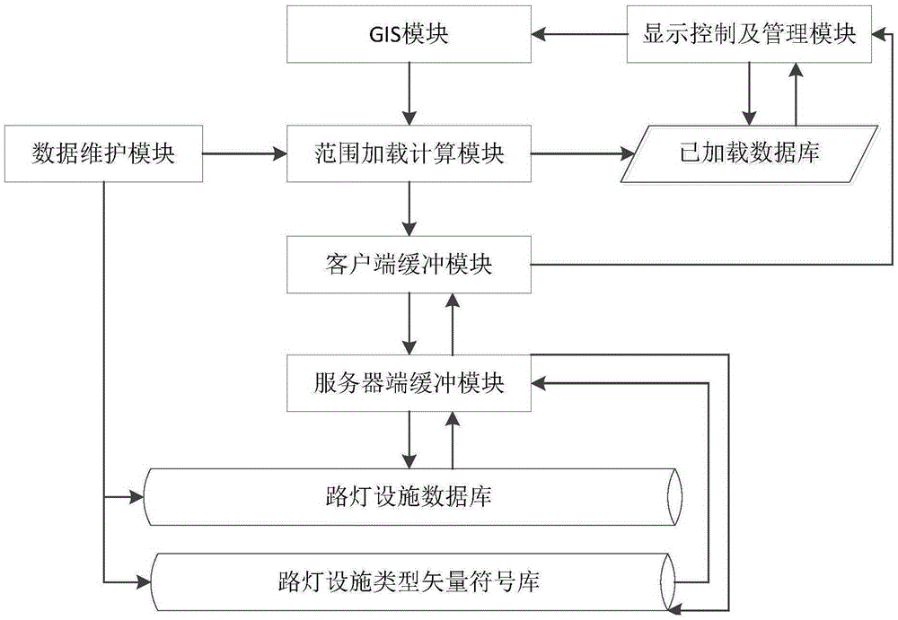
[0056] figure 1 It is a flow chart of data processing in the present invention.

[0057] Step 1: After the system is initialized, the server-side buffer module pre-stores all street light facility data and street light facility type vector symbol data, and synchronously transfers the pre-stored data to the client buffer module to keep the data consistent; Parameters such as the visible range map scale and the set map scale threshold are passed to the range loading calculation module.

[0058] Step 2: The range loading calculation module receives the map range, geographic scale, and set map scale threshold and other parameters transmitted by the GIS module in real time, and first queries the qualified street light facility data and street light facility type vector in the loaded database according to these parameters Symbol data, and then query the rem...


PUM


Abstract

The invention discloses a GIS based streetlight resource device intelligent display system and method. The system comprises a data maintenance module and a range loading computing module, wherein the data maintenance module is used for maintaining data of a streetlight facility database and a streetlight facility type vector symbol base and sending a data updating success instruction to the range loading computing module; the range loading computing module receives a query parameter from a GIS module, calls streetlight data from a loaded database according to the query parameter, and transmits the streetlight data to a display control and management module; if the streetlight data do not exist in the loaded database, the range loading computing module calls streetlight data from a client buffer module and transmits the streetlight data to the display control and management module; the client buffer module calls streetlight data from a server buffer module; and the server buffer module calls the streetlight data from the streetlight facility database and the streetlight facility type vector symbol base. Therefore, large amounts of streetlight facility information can be quickly loaded in a streetlight facility management system and is visually and reasonably displayed in detail by utilizing a GIS.

Description

technical field [0001] The invention relates to a GIS-based intelligent display system and method for street lamp resource equipment. Background technique [0002] The street lamp facility resource management system can carry out data format conversion, data inspection and storage, street lamp facility data query statistics, street lamp facility data editing management update, street lamp facility data printout and other maintenance and management for street lamp facilities, making the street lamp industry The management department has greatly improved the management level of street lamp facilities resources, and also reduced the management cost. However, the current existing street lamp facility resource management system still has the following defects: [0003] 1. The information display of street light facility resources is not intuitive and slow [0004] At present, the total number of street lighting equipment in cities with a small scale is more than hundreds of tho...

Claims


Application Information

Patent Timeline
Patent Type & Authority Applications(China)
IPC IPC(8): G06Q50/26G06F17/30
CPCG06Q50/26G06F16/29
Inventor 杜伟徐文鹏尚宪斌修择马述杰庄绪良吕令敏张超郝敬全蒋德民邓三
Owner TAIHUA WISDOM IND GRP CO LTD
Why Eureka
Eureka Blog
Learn More