Method and apparatus for providing geographic position information

A geographic location information and geographic location technology, applied in the field of terminal applications, can solve problems such as inaccurate description and inability to enjoy convenience, and achieve the effect of convenience in daily life

Inactive Publication Date: 2016-05-18
ALIBABA GRP HLDG LTD
View PDF6 Cites 13 Cited by
  • Summary
  • Abstract
  • Description
  • Claims
  • Application Information

AI Technical Summary

Problems solved by technology

However, if you are not familiar with the place and cannot accurately describe

Method used


Image

  • Method and apparatus for providing geographic position information
  • Method and apparatus for providing geographic position information
  • Method and apparatus for providing geographic position information

Examples


Embodiment 1

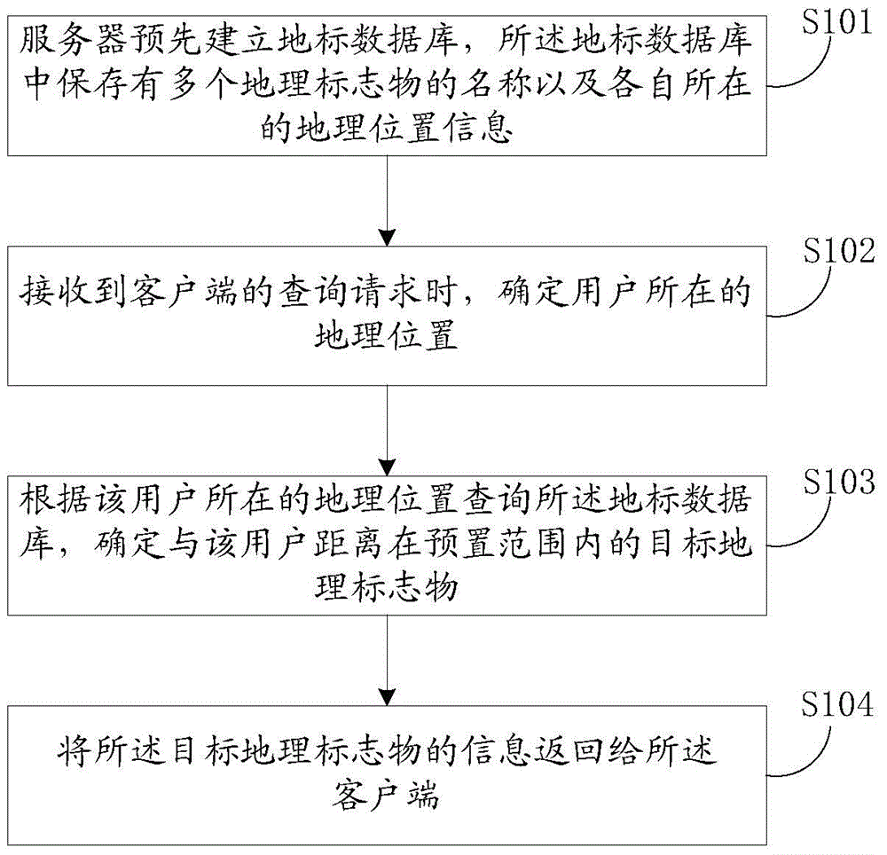
[0046] In the first embodiment, the mutual cooperation between the client and the server can be used to achieve the purpose of providing geographical indication information. Among them, see figure 1 In the first embodiment of this application, a method for providing geographic location information is provided from the perspective of a server. The method may include the following steps:

[0047] S101: The server pre-establishes a landmark database, and the landmark database stores the names of multiple geographic landmarks and their respective geographic location information;

[0048] There can be many ways to express data in the landmark database. For example, the format of the landmark database can be as shown in Table 1 below:

[0049] Table 1

[0050] Numbering

Geographical Indication Name

Location information

1

National Library

(x1,y1)

2

Shenzhou Building

(x2,y2)

...

...

...

[0051] There are many ways to build a landmark database. For example, there are some ma...

Embodiment 2

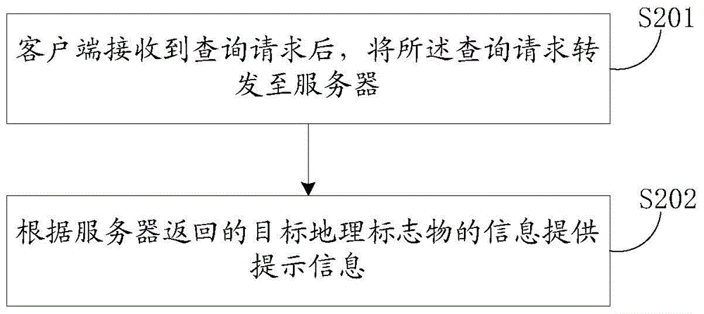
[0076] The second embodiment corresponds to the first embodiment, and the embodiment of the present application is introduced from the perspective of the client. See figure 2 The method for providing geographic location information provided in the second embodiment may specifically include the following steps:

[0077] S201: After receiving the query request, the client forwards the query request to the server, so that the server can determine a target geographic landmark within a preset distance from the user based on the pre-established landmark database and the geographic location information of the user. And return

[0078] S202: Provide prompt information according to the target geographical indication information returned by the server.

[0079] Since the second embodiment is different from the first embodiment only in terms of the description angle, the specific implementation details of each step of the second embodiment can refer to the introduction in the first embodiment...

Embodiment 3

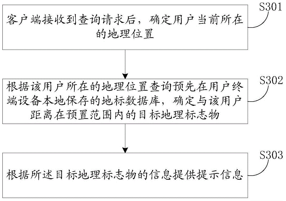
[0081] In the third embodiment, the landmark database established by the server can be pre-downloaded to the user's terminal device and stored locally. For example, the landmark database can be added to the installation package, so that when the user installs the client program, Download the landmark database to the terminal device and save it to the preset path. Of course, the landmark database can also be updated in a variety of ways. For example, after the server updates the landmark database, it pushes the updated information to the client, or the client periodically requests the server to update data, and so on. In short, in this implementation mode, when the user specifically needs to inquire about the geographic marker information in his vicinity, the client can directly use the locally stored landmark database for the query, instead of relying on the server.

[0082] That is to say, in specific implementation, in the solution provided in the third embodiment, the executio...


PUM


Abstract

The embodiment of the application discloses a method and apparatus for providing geographic position information. The method comprises: a server establishes a landmark database in advance, wherein titles of a plurality of geographical indication objects and respective geographic position information are stored into the landmark database; when a query request of a client is received, a geographic position of a user is determined; and according to the geographic position of the user, the landmark database is queried and a target geographical indication object at a distance away from the user in a preset range is determined; and the information of the target geographical indication object is returned to the client. According to the embodiment of the application, the geographic position of the user can be described by the user conveniently.

Description

Technical field [0001] This application relates to the field of terminal application technology, and in particular to methods and devices for providing geographic location information. Background technique [0002] In real life, people often encounter the following situations: when they come to a strange place, they need to describe their location to others so that they can find themselves. However, because they are not familiar with this place, they may not be able to accurately Describe it. [0003] For example, taxi-hailing software is a popular mobile app. After installing the app, users can input the starting point and destination in the App interface or by voice, and taxi drivers can choose whether to accept orders according to the route. The App provides great convenience for users' taxi needs. However, in the process of using the App, it is necessary to input the starting point position accurately so that the taxi can reach that position accurately. However, if you are n...

Claims


Application Information

Patent Timeline
IPC IPC(8): H04L29/08H04W4/02
Inventor 刘抒炎于志平
Owner ALIBABA GRP HLDG LTD
Why Eureka
Try Eureka