Determination method for satellite laser ceilometer pin point geometry positioning errors

A laser altimeter and geometric positioning technology, which is applied in the field of laser remote sensing, can solve the problem that the comprehensive evaluation of the geometric positioning error of the laser foot of the spaceborne laser altimeter can not be realized, etc.

Inactive Publication Date: 2016-06-01
WUHAN UNIV +1
View PDF1 Cites 6 Cited by
  • Summary
  • Abstract
  • Description
  • Claims
  • Application Information

AI Technical Summary

Problems solved by technology

Therefore, these methods can only analyze the influence of some error factors on the instantaneous positioning error of the laser foot point for the horizontal plane observation target, and cannot achieve a comprehensive evaluation of the geometric positioning error of the laser foot point of the spaceborne laser altimeter

Method used


Image

  • Determination method for satellite laser ceilometer pin point geometry positioning errors
  • Determination method for satellite laser ceilometer pin point geometry positioning errors
  • Determination method for satellite laser ceilometer pin point geometry positioning errors

Examples


Embodiment

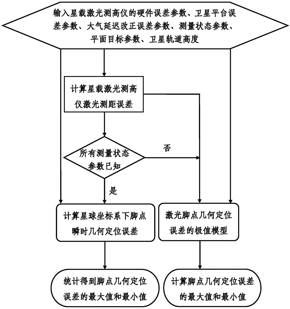
[0057] One, at first introduce the concrete method flow process of the present invention, mainly comprise the following steps:

[0058] 1. Input the initial parameters of the geometric positioning error of the feet of the spaceborne laser altimeter, including the following process:

[0059] (1.1) Input the hardware error parameters of the laser altimeter, including laser pointing angle error and hardware ranging error, installation angle error and installation position error;

[0060] (1.2) Input the error parameters of the satellite platform, including the attitude angle error of the satellite platform (including roll angle error, pitch angle error and heading angle error), the orbit determination error of the satellite platform, the placement angle error and placement of the attitude sensor and the position sensor position error;

[0061] (1.3) Input the atmospheric delay correction error parameter in the direction of laser emission;

[0062] (1.4) Input the measurement st...


PUM


Abstract

The invention relates to a determination method for satellite laser ceilometer pin point geometry positioning errors and belongs to the field of laser remote sensing. The problems that an existing pin point geometry positioning error analysis method neglects position and the angle placement errors between a laser measuring system and a carrying platform sensor, only provides partial instant geometry positioning error molds of laser pin points on the premise that height fluctuations of a measured target are not considered and does not analyze extreme values of laser pin point geometry positioning errors are solved. On the basis of the satellite laser ceilometer pin point geometry laser pin point geometry positioning process and error communication theory, the method for comprehensively determining the satellite laser ceilometer laser pin point geometry positioning errors is provided by comprehensively considering the influence on various error sources and plane target fluctuations; the analysis method with the combination of the instant geometry positioning error and the extreme geometry positioning error can achieve comprehensive analysis and evaluation of performance indexes obtained before and after emission of a satellite laser ceilometer.

Description

technical field [0001] The invention belongs to the field of laser remote sensing, and in particular relates to a method for determining the geometric positioning error of a foot point of a spaceborne laser altimeter, which is suitable for precision analysis and evaluation of the observation results of the spaceborne laser altimeter. Background technique [0002] The spaceborne laser altimeter is a laser remote sensing device installed on the surface of the satellite. It can accurately obtain the distance between the laser altimeter and the laser footpoint by measuring the transit time of the emitted laser pulse. Combined with the position and attitude data provided by the satellite platform, the precise calculation of the geometric positioning coordinates of the laser footpoint is realized. In the case of making full use of the satellite's autonomous flight, the spaceborne laser altimeter can observe the target digital elevation model covering the whole world. Very wide ra...

Claims


Application Information

Patent Timeline
Patent Type & Authority Applications(China)
IPC IPC(8): G01C25/00
CPCG01C25/00
Inventor 周辉李松金丽花李少辉郭高峰
Owner WUHAN UNIV
Why Eureka
Try Eureka