
A deep space probe landing autonomous optical navigation target imaging simulation system

A deep space probe and optical navigation technology, applied in the field of deep space probe landing autonomous optical navigation target imaging simulation system, can solve the problems of high cost, complex system, poor flexibility, etc.

Active Publication Date: 2018-07-31
BEIJING UNIV OF TECH
View PDF5 Cites 0 Cited by
  • Summary
  • Abstract
  • Description
  • Claims
  • Application Information

AI Technical Summary

Problems solved by technology

[0013] The purpose of the present invention is to provide a deep-space probe landing autonomous optical navigation target imaging simulation system to overcome the defects of complex, expensive and poor flexibility of the existing system, so that researchers can realize deep-space probe autonomy based on this system. Rapid Validation of Optical Navigation Algorithms

Method used


Image

  • A deep space probe landing autonomous optical navigation target imaging simulation system

Examples


Embodiment Construction

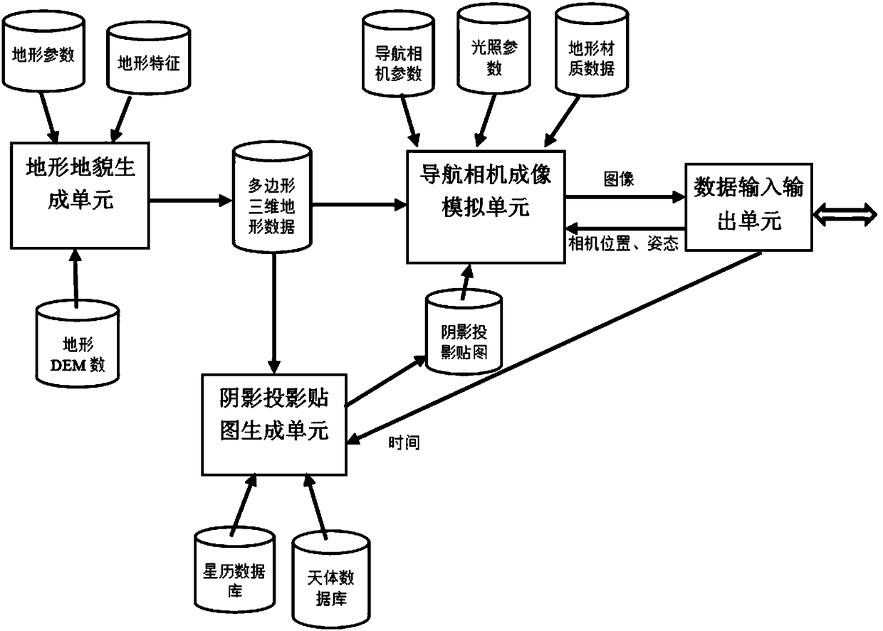
[0022] Combine below figure 1 The present invention will be further described with specific embodiments.

[0023] The target celestial body terrain and landform generation unit, including its corresponding terrain DEM database and two configuration files.

[0024] The target celestial body topography generation unit is a separate program. Before using this system for simulation, researchers must first use the target celestial body topography generation unit to pre-generate terrain data that meets the required accuracy to generate the target landing celestial body.

[0025] Terrain DEM (Digital Elevation Model) database contains rough DEM data of some celestial bodies that humans have explored currently, including the DEM data of the moon, Mars, 433Eros, and 25143Itokawa. When the database does not contain the target celestial body that researchers want to simulate landing When collecting data, researchers can manually import the topographic DEM data of the target celestial bo...


PUM


Abstract

The invention discloses a kinetics analog system for the landing of an asteroid probe. A target celestial body topography generation unit is in charge of reading topographical gross DEM (Dynamic Effect Model) data, surface physical parameter profiles, and surface feature profiles, and polygon three dimensional topographical data conforming with the target celestial body topographical features are generated by an algorithm; a shadow projection generation unit is in charge of calculating the position of the target celestial body relative to the sun and the incident angle of solar ray at the current analog time according to an ephemeris, and rendering to generate a shadow projection map; a navigation camera imaging analog unit is in charge of rendering to generate an image in accordance with the requirements of a camera according to the information of current camera parameters, positions, illumination parameters, and topographical texture; a data input and output unit is in charge of receiving and resolving the data of the camera position, attitude parameters and current analog time sent over by a client side according to a protocol, meanwhile packaging and sending the image data generated by rendering to the client side according to the protocol so as to be used in the resolution of an autonomous optical navigation system, thus realizing the imaging analog of the navigated target.

Description

technical field [0001] The invention relates to a deep-space probe landing autonomous optical navigation target imaging simulation system, belonging to a digital simulation system based on virtual reality technology. Background technique [0002] In deep space exploration, because the target celestial body is far away from the earth, there is a long communication delay between the detector and the ground station, and the navigation and guidance method based on the deep space network cannot meet the requirements. Therefore, the landing detector must have autonomous navigation, Guidance and Control (GNC) capability. The optical navigation system has the advantages of small size, low power consumption, and large amount of information. It can provide the position, speed, and attitude information of the probe during the entire landing process, and realize obstacle detection in the final landing section to ensure the safe soft landing of the probe. The navigation system based on ...

Claims


Application Information

Patent Timeline
Patent Type & Authority Patents(China)
IPC IPC(8): G01C25/00
CPCG01C25/00
Inventor 阮晓钢肖尧张晓平黄静朱晓庆陈志刚林佳柴洁陈岩伊朝阳刘冰李诚
Owner BEIJING UNIV OF TECH
Learn More