Multi-waypoint navigation route planning method and system

A technology for navigation routes and route planning, which is applied in radio wave measurement systems, satellite radio beacon positioning systems, navigation and other directions, and can solve the problems that navigation algorithms cannot comprehensively consider user needs and are not well implemented.

Inactive Publication Date: 2016-06-15
闫凯 +1
View PDF5 Cites 52 Cited by
  • Summary
  • Abstract
  • Description
  • Claims
  • Application Information

AI Technical Summary

Problems solved by technology

[0007] In summary, judging from the sentence "providing the optimal road driving plan that users think is the ultimate goal in this field in the shortest time", finding the optimal route that users think has not been obtained. well realized
Especially in multi-destination route planning, navigation algorithms cannot comprehensively consider user needs

Method used


Image

  • Multi-waypoint navigation route planning method and system
  • Multi-waypoint navigation route planning method and system
  • Multi-waypoint navigation route planning method and system

Examples


Embodiment Construction

[0059] In order to solve the above problems and achieve the proposed goal, the present invention mainly includes two parts: a non-equal priority-oriented multi-way point (destination) road navigation planning algorithm model and a multi-influence factor weight setting scheme based on machine learning.

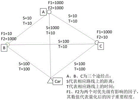
[0060]The first part is the multi-way point (destination) road navigation planning algorithm model for non-equal priority. From the perspective of the way points are considered in the navigation route planning algorithm, it can be divided into three categories: the first type is the traditional two-point model, which only includes the starting point and the end point, and does not include the passing point; the second type is The multi-point model of waypoints can be added, but the waypoints are not distinguished, that is, waypoints of equal priority; the third type is the model proposed by the present invention that can add waypoints of non-equal priority. The implementation m...


PUM


Abstract

The invention provides a multi-waypoint (destination) navigation route planning method and system in an actual demand situation that the multiple waypoints have different priority under multi-factor influence. The method adopts a weight scoring based optimum route determining model and a machine learning based multi-influence-factor weight coefficient determining method. Specifically, a multi-point road planning model oriented to multiple waypoints with different priority is designed firstly; the machine learning based influence factor weight coefficient determining method is provided for determining coefficients in the model; then the multi-point road planning system capable of being widely popularized to numerous fields is obtained. One new solution is provided for multi-influence-factor and multi-waypoint route navigation, and route planning is more intelligent, higher in efficiency, more dynamic and more automatic.

Description

technical field [0001] The present invention relates to the field of road navigation planning and optimal dispatching, and specifically relates to a method and system for route planning and influencing factor weight determination in the context of multiple passing points (multiple destinations) and multiple influencing factors. Background technique [0002] In recent years, with the popularization of transportation and the increase of people's travel, especially long-distance travel, route navigation systems (including car, bicycle, and walking navigation) running on various navigators and mobile terminals have developed rapidly. In particular, the electronic map program using GPS installed on mobile terminals has brought a revolution to people's travel plans by virtue of its low price, real-time updated map data, and the ability to easily combine with other application software. Users only need to mark the starting point and ending point on the electronic map, and they ca...

Claims


Application Information

Patent Timeline
Patent Type & Authority Applications(China)
IPC IPC(8): G01C21/34G01S19/39
CPCG01C21/343G01S19/39
Inventor 闫凯刘钊
Owner 闫凯
Why Eureka
Try Eureka