Dynamic turning navigation method based road network checkpoints and travel time indexes

A technology of travel time and navigation method, which is applied in the field of intelligent transportation systems and Internet of Vehicles, and can solve problems such as difficult to accurately predict traffic conditions, ignore real-time traffic conditions, and fail to guarantee the shortest path in time

Active Publication Date: 2016-06-22
徐亚国 +1
View PDF8 Cites 18 Cited by
  • Summary
  • Abstract
  • Description
  • Claims
  • Application Information

AI Technical Summary

Problems solved by technology

[0003] The current vehicle navigation terminal or navigation route information service is mainly based on three types of navigation methods. The first one ignores the real-time traffic conditions and only searches for the shortest path (such as the traditional GPS navigation terminal). Obviously, this method only gives the distance The shortest path rather than the path with the shortest time; the second is to give the real-time traffic conditions of the entire city road network, allowing users to decide the optimal path based on experience (such as Baidu map, Gaode map, GoogleTraffic, etc.), this method cannot guarantee The user must be able to obtain the shortest route in time; the third is based on the update of real-time road conditions (mainly the travel time of each road section), and continuously recommends one or several optimal routes from the current location to the destination to the user (such as Waze, NokiaHere, AutoNavi maps, and some GPS navigation devices, etc.), this type of product is mainly based on real-time road travel time, and obtains the optimal dynamic steering result through algorithms such as shortest path search, which is currently a more commonly used road condition navigation processing method
However, in the urban road network during peak traffic hours, the structure of the road network is complex, and the travel time of the road sections changes rapidly. Even if the navigation method based on real-time traffic conditions, it is difficult to accurately predict the traffic status of the next stage, such as the real-time optimal route. Periodic congestion occurs; even if the dynamic update mode is used, it can only provide a local optimal solution, so that the vehicle-mounted navigation terminal vehicles not only cannot find the most efficient path, but also cause vehicle-mounted navigation terminal vehicles to gather, causing urban roads Evolution of road network traffic to a state of increased congestion

Method used


Image

  • Dynamic turning navigation method based road network checkpoints and travel time indexes
  • Dynamic turning navigation method based road network checkpoints and travel time indexes
  • Dynamic turning navigation method based road network checkpoints and travel time indexes

Examples


Embodiment Construction

[0067] The preferred embodiments of the present invention will be described in detail below in conjunction with the accompanying drawings, so that the advantages and features of the present invention can be more easily understood by those skilled in the art, so as to define the protection scope of the present invention more clearly.

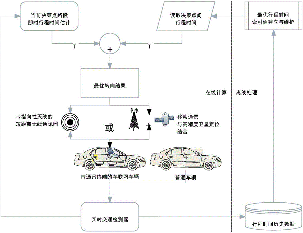
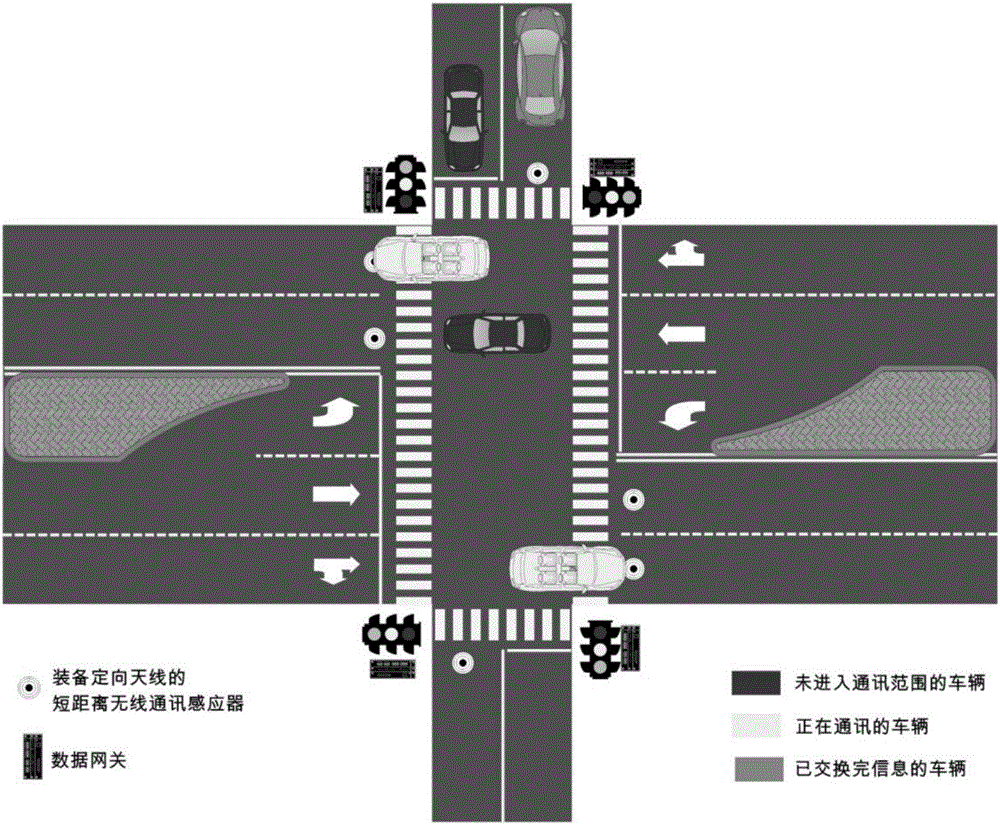
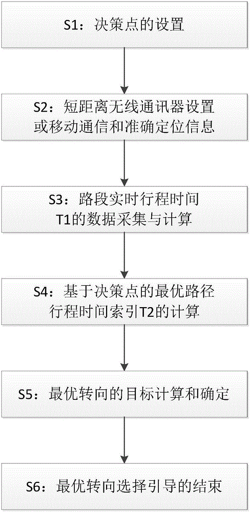
[0068] combine Figure 1-Figure 4 As shown, the present invention provides a dynamic steering navigation method based on the travel time index value of the road network decision point, including

[0069] Step S1, setting of decision points

[0070] 1) The location of the system's decision point intersection should be able to meet the enough distance for the guided vehicle to change lanes and the driver's reaction time, that is, the user's vehicle can reach the stop line at the next intersection after receiving the optimal steering suggestion information. Change the lane so that the vehicle can complete the steering according to the selected sugg...


PUM


Abstract

The invention discloses a dynamic turning navigation method based road network checkpoints and travel time indexes. Downstream of an intersection in a road network is set as a checkpoint, and communication and sensing of user vehicles at each checkpoint can be realized through a short-distance communication or mobile communication mode. Under a short-distance communication mode, the checkpoint of each lane is provided with a short-distance wireless communication road sign for sensing vehicles and guiding the user vehicles with an on-board communication terminal. Under the mobile communication mode, the user vehicle reports the coordinate and turning guiding request when arriving at a certain distance to the coordinate of a checkpoint through mobile communication. The minimal summation of instant traffic data and historical optimal path travel time index is used as an object, optimal turning selection suggestion is provided to the user vehicles arriving at each checkpoint every moment, and dynamic path navigation information with shortest travel time is provided for the vehicles of each moment. Indexes are employed in the method, which reduces real-time computational complexity, improves response speed to real-time road conditions and ensures optimal global final navigation trail.

Description

technical field [0001] The present invention relates to the technical field of intelligent transportation systems and Internet of Vehicles, and more specifically, to a dynamic steering navigation method based on travel time index values ​​of road network decision points. Background technique [0002] With the rapid development of the mobile Internet and the maturity of hand-held or vehicle-mounted terminal technologies, various mobile dynamic traffic information services have gradually penetrated into all aspects of urban traffic travel, especially in navigation applications for vehicle travel routes and road condition planning decisions. more important role. The establishment of road condition navigation information service in the urban road network not only provides great convenience for individual vehicles to travel, but also affects the route selection behavior of individual vehicles with the increase of the service utilization rate, thus having a profound impact on urba...

Claims


Application Information

Patent Timeline
Patent Type & Authority Applications(China)
IPC IPC(8): G08G1/0968G08G1/01
CPCG08G1/0125G08G1/0137G08G1/096822G08G1/096861
Inventor 徐亚国徐广宁
Owner 徐亚国
Why Eureka
Try Eureka