Seabed relative geodesic method

A relative distance and base-based technology, applied in seismology, measuring devices, geophysical measurements, etc., can solve problems such as long-distance one-way observation method deviation

Active Publication Date: 2016-08-31
SOUTH CHINA SEA INST OF OCEANOLOGY - CHINESE ACAD OF SCI
View PDF3 Cites 2 Cited by
  • Summary
  • Abstract
  • Description
  • Claims
  • Application Information

AI Technical Summary

Problems solved by technology

[0010] In view of the deficiencies of the above-mentioned prior art, the purpose of the present invention is to provide a relative geodetic method f...

Method used


Image

  • Seabed relative geodesic method
  • Seabed relative geodesic method
  • Seabed relative geodesic method

Examples


Embodiment Construction

[0032] The present invention provides a seabed relative geodetic method. In order to make the purpose, technical solution and effect of the present invention clearer and clearer, the present invention will be further described in detail below with reference to the accompanying drawings and examples. It should be understood that the specific embodiments described here are only used to explain the present invention, not to limit the present invention.

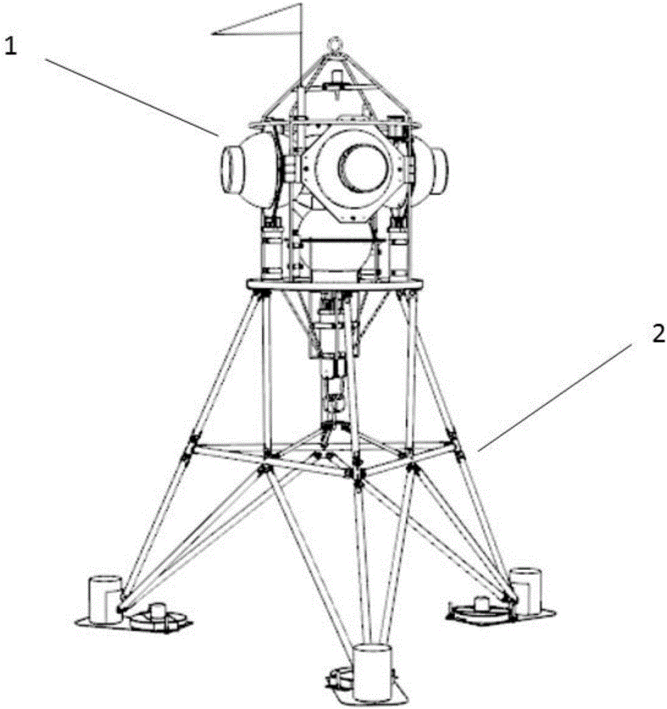
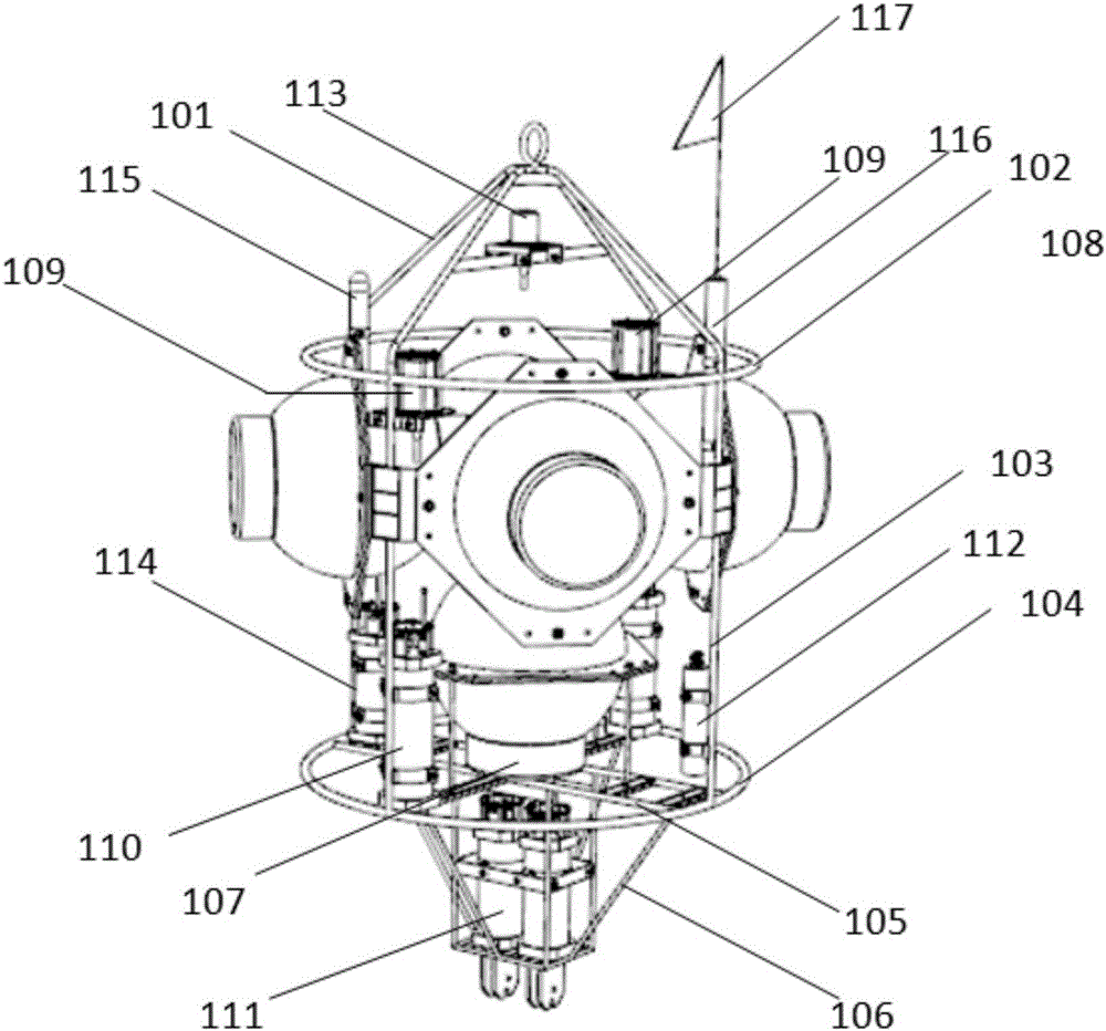
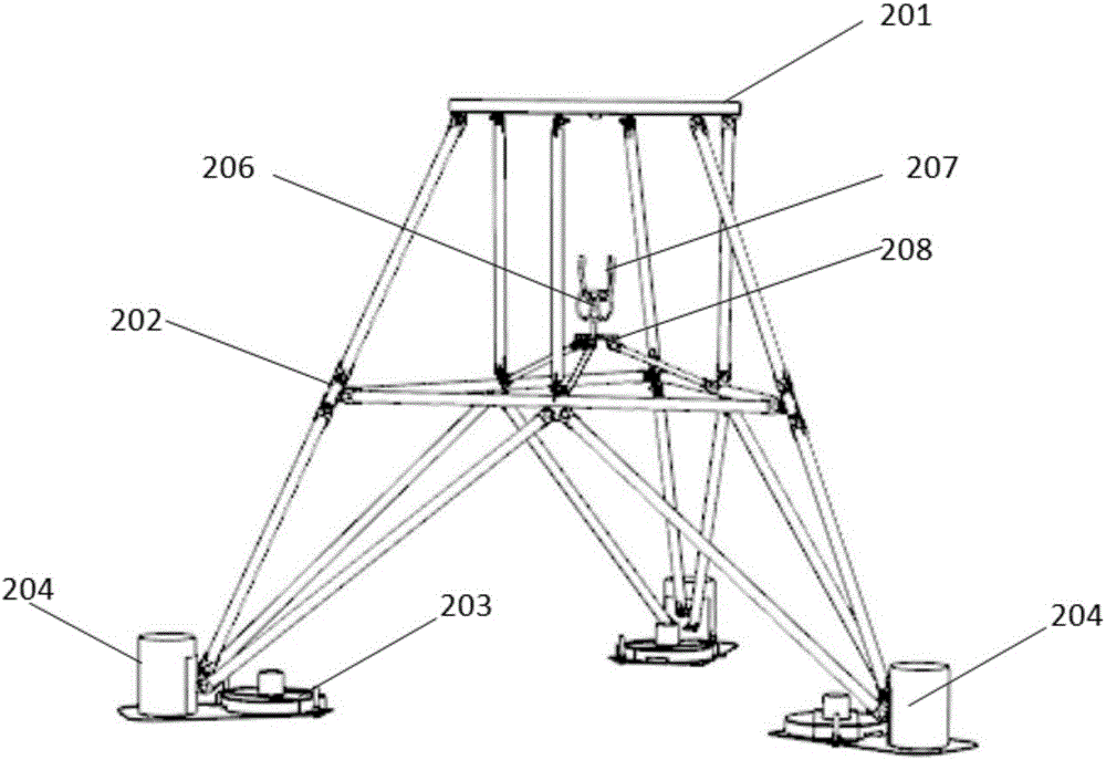
[0033] For the convenience of understanding, the structure and functions of the base observation platform are firstly introduced, please refer to figure 1 , each base observation platform is generally composed of a recovery system 1 and a discarding support 2; as figure 2 As shown, the recovery system includes an integrated mounting frame, 5 floating balls, 2 sets of three-body acoustic releasers, 1 high-precision pressure sensor and 1 set of acoustic range finder; the integrated mounting frame is shaped like a pointed bottom T...


PUM


Abstract

The invention discloses a seabed relative geodesic method, comprising steps of putting a plurality of subbottom observation platforms to seabed preset positions to constitute an observation net, realizing a relative geodesic function of each base station through performing continuous observation and self-contained storage on a relative distance between the base stations and varying data so as to obtain change of relative motion speed, displacement and vertical displacement of the base stations, calculating coupling coefficients of various segments of a subduction zone by combining with land GPS data, analyzing stress accumulation statuses of various segments of the subduction zone and estimating earthquake occurrence possibility and earthquake magnitude. The seabed relative geodesic method can perform long term accurate observation and recording on seabed horizontal and vertical deformation and provides the basis to the possibility of the earthquake occurrence in the subduction zone.

Description

technical field [0001] The invention relates to the technical field of marine geological scientific observation, in particular to a seabed relative geodetic method. Background technique [0002] The seabed, which accounts for two-thirds of the total surface of the earth, is not only a storage place for important resources such as oil, gas, energy, and metal minerals, but also a place where various basic scientific issues are bred. However, there are only a few deep-sea surveys in Japan and the United States. Earth observation station. The example of the 2011 Japanese earthquake showed that the estimation of sea deformation by mainland GPS is seriously insufficient. It is necessary to establish a deep-sea geodesy observation network to directly monitor displacement changes such as submarine faults, earthquakes, tsunamis, volcanoes, sediment transport, and coastal slippage. [0003] Several major earthquakes in recent years have occurred in areas where scientists believe that...

Claims


Application Information

Patent Timeline
IPC IPC(8): G01V1/38
CPCG01V1/38G01V1/3852
Inventor 林间孙珍孙兆华黄健龙黄锐李晓伟
Owner SOUTH CHINA SEA INST OF OCEANOLOGY - CHINESE ACAD OF SCI
Why Eureka
Try Eureka