AOA-based two-dimensional wireless sensor network semi-definite programming positioning method

A wireless sensor and semi-definite planning technology, applied in positioning, radio wave measurement systems, instruments, etc., can solve problems such as reducing the positioning accuracy of target nodes, and achieve the effect of improving positioning accuracy

Inactive Publication Date: 2016-10-12
TIANJIN UNIV
View PDF0 Cites 23 Cited by
  • Summary
  • Abstract
  • Description
  • Claims
  • Application Information

AI Technical Summary

Benefits of technology

In this patented technology, it uses signals from different sources like radar or lidars for location determination purposes. By converting these data angles into distances they are mapped onto space, an optimum estimate of their positions becomes possible with minimal interference during reception compared to traditional methods that require multiple measurements overlapping each other's range resolution. Additionally, there may be some overlap when comparing two locations due to factors such as atmospheric conditions or movement caused by vehicles. Overall, this technique helps improve both locality and overall efficiency in accurately locating targets without relying heavily upon any external references.

Problems solved by technology

This patented describes how wirelessly sensed networks work together with other technologies like radar or sonar systems that help track targets accurately over long distances. These techniques use signals from multiple sources at once to calculate their location by analyzing them separately. While these techniques improve upon each others they still require expensive infrastructure components due to the required communication protocols needed along with complex calculations involved during data analysis process. Therefore, there has arisen a problem where current solutions cannot provide accurate results when dealing with challenges related to space exploration and undersea drilling operations.

Method used


Image

  • AOA-based two-dimensional wireless sensor network semi-definite programming positioning method
  • AOA-based two-dimensional wireless sensor network semi-definite programming positioning method
  • AOA-based two-dimensional wireless sensor network semi-definite programming positioning method

Examples


Embodiment Construction

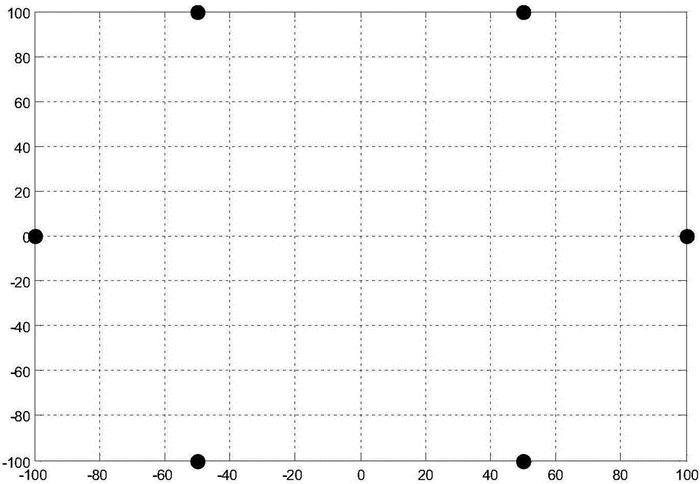
[0018] In this method, the reference nodes of the two-dimensional wireless sensor network adopt an elliptical distribution form as follows: figure 1 , that is, the reference nodes are arranged in a rectangular area, where the target node is set to X=[0,25], the number of reference nodes is set to 6, and the position coordinates of the reference nodes are expressed as: X 1 =[-100,0],X 2 =[-50,100],X 3 =[-50,-100], X 4 =[50,100],X 5 =[50,-100],X 6 =[100,0].

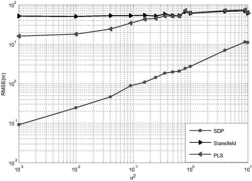
[0019] We will perform M on the proposed localization algorithm by MATLAB c = 1000 Monte Carlo simulation experiments, and compared with existing positioning algorithms. We mainly use the positioning root mean square error (RMSE) to compare and evaluate the proposed algorithm of the present invention and the existing algorithms. The expression of RMSE is as follows:

[0020] R M S E = E [ ( ...


PUM


Abstract

The invention relates to an AOA-based two-dimensional wireless sensor network semi-definite programming positioning method comprising the following steps: assuming that there is no obstruction between a reference node and a target node to be positioned in a wireless sensor network, and measuring the angle of arrival of each signal; converting the angles of arrival of the signals into distance information between the nodes; converting a problem of wireless sensor network target node positioning into a mathematical optimization problem of maximum likelihood estimate MLE and solving the problem, and providing an optimized objective function for subsequent steps; introducing redundant variables to convert the mathematical optimization problem of maximum likelihood estimate MLE into a constrained optimization problem; converting the obtained constrained optimization problem into a semi-definite programming SDP convex optimization problem using a mini-max criterion and a semi-definite relaxation SDR method, and getting an optimal solution, thus completing positioning of the target node. Through the method, the precision of target node positioning is improved.

Description


Claims


Application Information

Patent Timeline
Owner TIANJIN UNIV
Why Eureka
Try Eureka