Unified framework for precise vision-aided navigation

a vision-aided navigation and unified framework technology, applied in the field of visual odometry, can solve the problems of insufficient assistance for users, inability to reliably work with gps, and most of the available navigation systems to function efficiently, so as to reduce or eliminate the accumulation of navigation drift, improve visual odometry performance, and improve the effect of visual odometry performan

Active Publication Date: 2008-07-10
SRI INTERNATIONAL
View PDF5 Cites 138 Cited by
  • Summary
  • Abstract
  • Description
  • Claims
  • Application Information

AI Technical Summary

Benefits of technology

[0012]According to an embodiment of the present invention, a framework is provided which improves visual odometry performance by recognizing previously visited locations and using information related to the previous visits to correct drift accumulated during navigation. Specifically, at each traveled location along a route, a set of distinctive visual landmarks is automatically extracted from the target scene and inserted dynamically into a landmark database. As the user travels to a new location, a new set of visual landmarks i

Problems solved by technology

However, most of the available navigation systems do not function efficiently and fail frequently under certain circumstances.
However, GPS is limited in that it cannot work reliably once the satellite signals are blocked or unavailable in, for example, “GPS-denied” environments such as indoors, forests, urban

Method used


Image

  • Unified framework for precise vision-aided navigation
  • Unified framework for precise vision-aided navigation
  • Unified framework for precise vision-aided navigation

Examples


Embodiment Construction

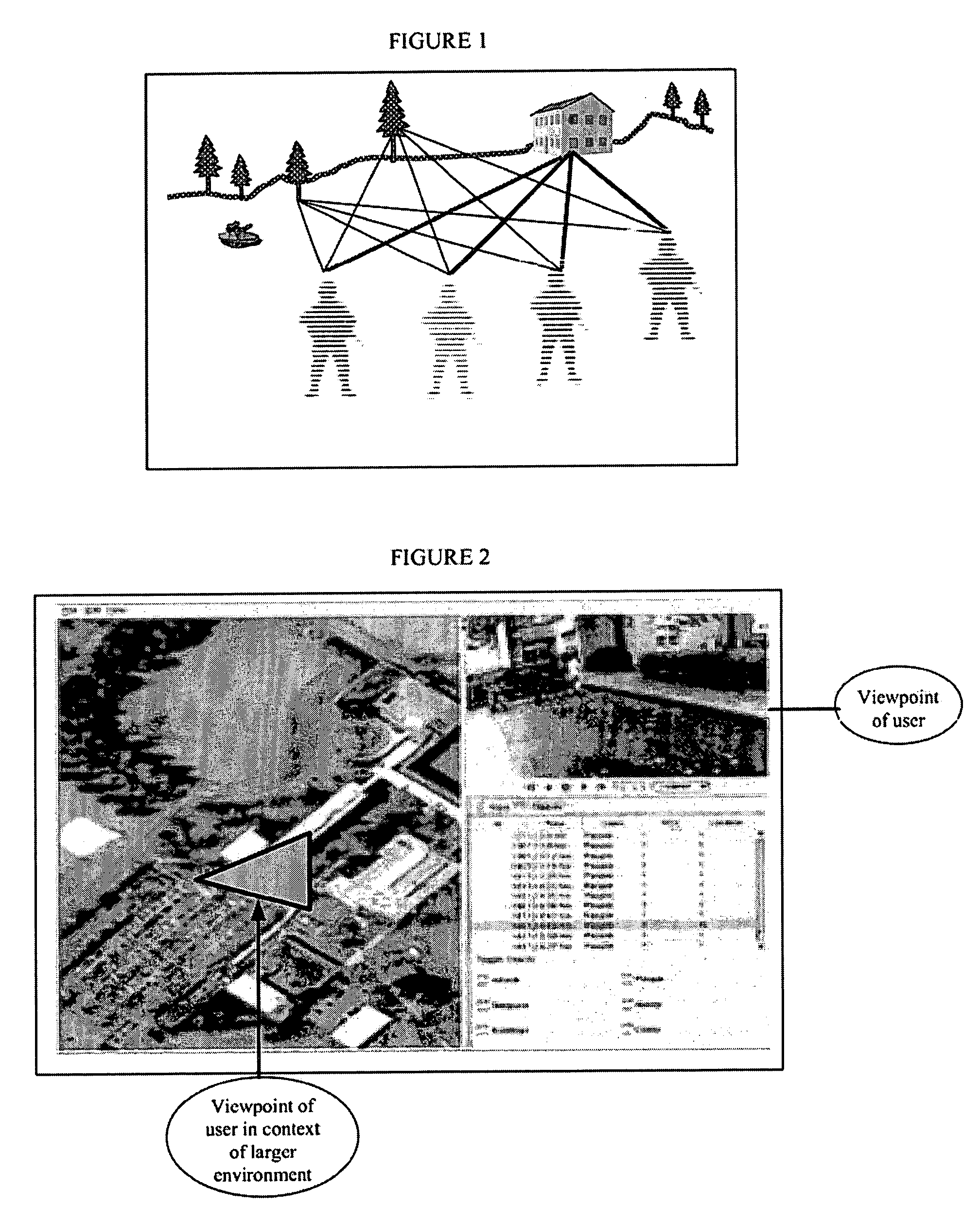
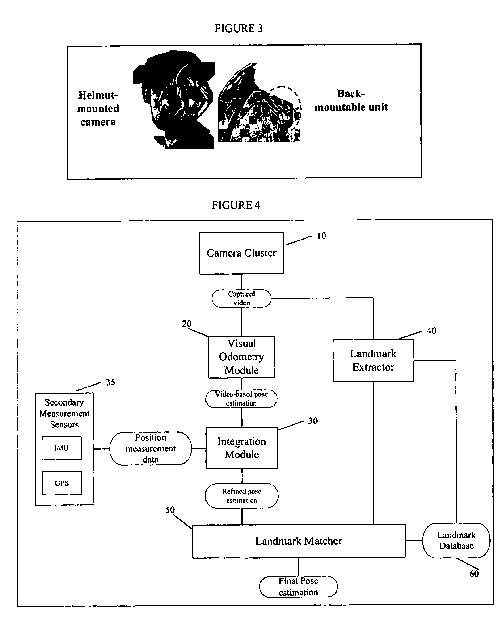
[0034]The present invention relates to vision-based navigation systems and methods for determining location and navigational information related to a user and / or other object of interest. An overall system and functional flow diagram according to an embodiment of the present invention is shown in FIG. 4. The systems and methods of the present invention provide for the real-time capture of visual data using a multi-camera framework and multi-camera visual odometry (described below in detail with reference to FIGS. 3, 5, and 6); integration of visual odometry with secondary measurement sensors (e.g., an inertial measurement unit (IMU) and / or a GPS unit) (described in detail with reference to FIG. 3); global landmark recognition including landmark extraction, landmark matching, and landmark database management and searching (described in detail with reference to FIGS. 3, 7, 8, and 9).

[0035]As shown in FIG. 4, the vision-based navigation system 1 (herein referred to as the “Navigation S...


PUM


Abstract

A system and method for efficiently locating in 3D an object of interest in a target scene using video information captured by a plurality of cameras. The system and method provide for multi-camera visual odometry wherein pose estimates are generated for each camera by all of the cameras in the multi-camera configuration. Furthermore, the system and method can locate and identify salient landmarks in the target scene using any of the cameras in the multi-camera configuration and compare the identified landmark against a database of previously identified landmarks. In addition, the system and method provide for the integration of video-based pose estimations with position measurement data captured by one or more secondary measurement sensors, such as, for example, Inertial Measurement Units (IMUs) and Global Positioning System (GPS) units.

Description

CROSS-REFERENCE TO RELATED APPLICATION[0001]This application claims the benefit of U.S. Provisional Application No. 60 / 868,227, filed on Dec. 1, 2006. U.S. Provisional Application No. 60 / 868,227 is incorporated by reference herein.STATEMENT REGARDING FEDERALLY SPONSORED RESEARCH OR DEVELOPMENT[0002]The U.S. Government has a paid-up license in this invention and the right in limited circumstances to require the patent owner to license others on reasonable terms as provided for by the terms of Contract No. M67854-05-C-8006 awarded by the Office of Naval Research.FIELD OF THE INVENTION[0003]The present invention relates generally to visual odometry, particularly to a system and method for enhanced route visualization in mission planning applications.BACKGROUND OF THE INVENTION[0004]Precise and efficient navigation systems are very important for many applications involving location identification, route planning, autonomous robot navigation, unknown environment map building, etc. Howeve...

Claims


Application Information

Patent Timeline
IPC IPC(8): G01C21/00H04N13/243
CPCG01C21/005G06T7/0044G06K9/3216G01C21/165G06T7/74H04N13/239H04N13/243G06V10/245G01C21/1656G06V20/56G06F18/22B60R1/00H04N2013/0081
Inventor SAMARASEKERA, SUPUNKUMAR, RAKESHOSKIPER, TARAGAYZHU, ZHIWEINARODITSKY, OLEGSAWHNEY, HARPREET
Owner SRI INTERNATIONAL
Why Eureka
Try Eureka