Method for Establishing Space Coordinate System Applicable to Near-field Target Imaging

A space coordinate system and target imaging technology, applied in the field of VLBI space detector imaging, can solve the problems of lack of space detectors, the applicability of space detectors to be studied, affecting the quality of VLBI imaging and the required position accuracy, etc., to achieve accurate imaging , high precision effect

Active Publication Date: 2019-03-01
SHANGHAI ASTRONOMICAL OBSERVATORY CHINESE ACAD OF SCI
View PDF5 Cites 0 Cited by
  • Summary
  • Abstract
  • Description
  • Claims
  • Application Information

AI Technical Summary

Problems solved by technology

However, the space probe is constantly changing in the celestial coordinate system, which causes the direction of the W-axis to change constantly, and three quantities (right ascension, declination, distance) are needed to describe the position of the probe on the spherical surface. coordinate system, therefore, the applicability of the existing method for establishing the UVW coordinate system of extragalactic radio sources to space detectors remains to be studied
[0012] At the same time, according to the formula (7), in the existing scheme suitable for establishing the UVW coordinate system of the space probe, the influence of the distance error between the probe and the earth is not analyzed
This error will affect the VLBI imaging quality of the target and the required position accuracy
[0013] At present, there is still a lack of a high-precision space detector space coordinate system establishment method, which is suitable for VLBI to accurately image space targets closer to the earth

Method used


Image

  • Method for Establishing Space Coordinate System Applicable to Near-field Target Imaging
  • Method for Establishing Space Coordinate System Applicable to Near-field Target Imaging
  • Method for Establishing Space Coordinate System Applicable to Near-field Target Imaging

Examples


Embodiment Construction

[0043] According to the attached Figure 1-4 , a preferred embodiment of the present invention is given and described in detail to help better understand the functions and features of the present invention.

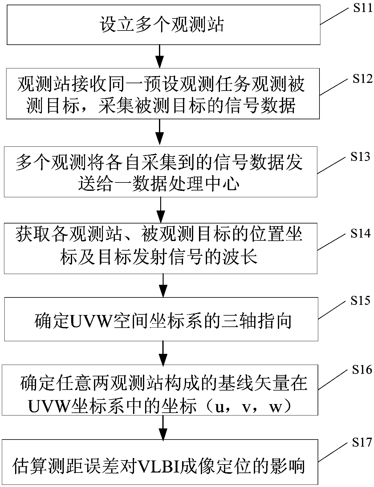
[0044] see figure 1 , a method for establishing a spatial coordinate system suitable for near-field target imaging of the present invention, comprising the steps of:

[0045] S11: Setting multiple observation stations;

[0046] S12: Multiple observation stations receive the same preset observation task, observe a measured target according to the content of the preset observation task, and collect signal data of the measured target at the same time;

[0047] S13: multiple observation stations send the signal data collected by them to a data processing center;

[0048] S14: Obtain the position coordinates of each observation station and the observed target, as well as the observation wavelength of the signal emitted by the measured target;

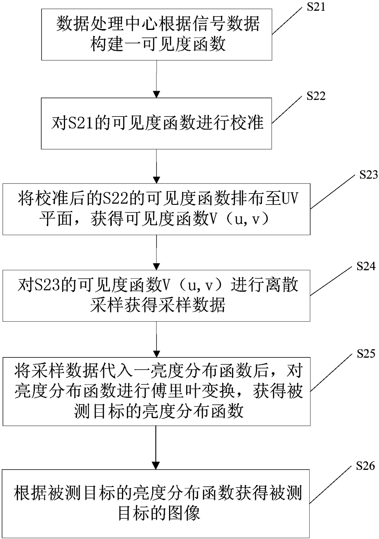
[0049] S15: Construct a UVW ...


PUM


Abstract

The invention provides a method for establishing a space coordinate system suitable for near-field target imaging. The method comprises: obtaining position coordinates of observation stations and an observed target and a signal emission wavelength or frequency; determining directions of U, V, and W axes to establish a UVW space rectangular coordinate system; and calculating the coordinates of a baseline vector constituted from any two observation stations in the UVW coordinate system. According to the method, a space rectangular coordinate system for lunar distance or a space probe in the solar system or other near-field targets is established. The method provides a foundation for VLBI imaging, is high in precision, and is suitable for near-field targets.

Description

technical field [0001] The invention relates to the field of VLBI space detector imaging, in particular to a method for establishing a space coordinate system and an imaging method suitable for near-field target imaging. Background technique [0002] In the traditional VLBI (Very Long Baseline Interferometry, very long baseline interferometry) technology, VLBI imaging technology only images extragalactic radio sources and obtains their positions. , Mars, Saturn, Venus and other solar system probes have improved their positional accuracy to the milliarcsecond (mas) level or even higher and carried out relevant scientific research. [0003] An existing coordinate system establishment relationship equation suitable for extragalactic radio sources is: [0004] [0005] In formula (5), B is the length of the baseline, λ is the observation wavelength, and H b ,δ b are the right ascension and declination values ​​of the baseline vector, respectively, and Hs and δs are the rig...

Claims


Application Information

Patent Timeline
Patent Type & Authority Patents(China)
IPC IPC(8): G01C21/00
CPCG01C21/00
Inventor 郑为民童锋贤
Owner SHANGHAI ASTRONOMICAL OBSERVATORY CHINESE ACAD OF SCI
Why Eureka
Try Eureka