Interactive 3D digital city construction and display method

A three-dimensional digital and display method technology, applied in the field of spatial information, can solve the problems of inability to manage the database in a unified manner, no interaction function, inability to view internal details and human-computer interaction, etc., and achieve high efficiency and low cost.

Active Publication Date: 2017-01-04
程昊 +2
View PDF3 Cites 38 Cited by
  • Summary
  • Abstract
  • Description
  • Claims
  • Application Information

AI Technical Summary

Problems solved by technology

[0004] The use of 3D urban building models and street view maps is increasingly becoming an important part of digital city construction. Compared with 2D maps, 3D models and street view maps are more intuitive, but the current 3D models can only browse the external features of buildings, and cannot Internal detail viewing and human-computer ...

Method used


Image

  • Interactive 3D digital city construction and display method
  • Interactive 3D digital city construction and display method
  • Interactive 3D digital city construction and display method

Examples


Embodiment Construction

[0052] A method for constructing and displaying a realistic three-dimensional digital city, the specific steps of which are as follows:

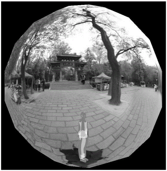
[0053] Step 1. Data preparation such as panorama shooting.

[0054] Make a panorama shooting plan, shoot and generate panoramas.

[0055] The generation of the panorama uses the method of compositing photos from different shooting angles at the same shooting location. The photos of different shooting points follow a unified starting shooting direction, shooting sequence and unified composition sequence to ensure that the panoramas of all shooting points have a unified direction.

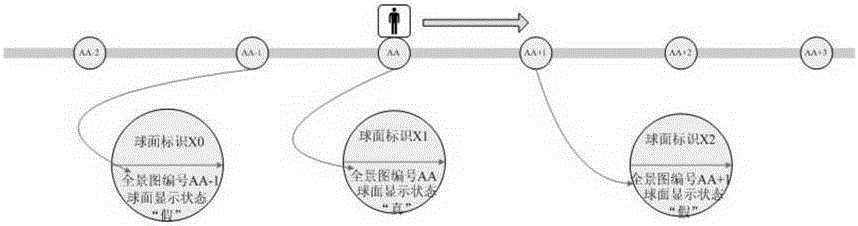
[0056] Define the intersection of 2 or more roads as "intersection", define the road between each two intersections as "road section", and the types of shooting points are divided into 2 types, one is located at the "intersection", which is defined as "intersection point" ; One class is located in "road section", defined as "road section point".

[0057] Number t...


PUM


Abstract

The invention discloses an interactive 3D digital city construction and display method. The method is realized via live-action 3D digital city construction and display and modeling 3D digital city construction and display. According to live-action 3D digital city construction and display, a panoramagram shot by a camera is used, and pasted to a 3D spherical surface, the moving track of people is simulated according to the spatial sequence, the panoramagram at a corresponding coordinate position in the spherical surface is replaced in real time and displayed for users. According to modeling 3D digital city construction and display, pre-compiled CAD standard segments are used to draft 2D CAD as-built drawings of present and newly built buildings, the corresponding segments are assigned with values, and 2D graphs and 3D models of the buildings are output, integrated into 2D and 3D spaces according to coordinates, and displayed for the users, The low-cost, high-efficiency, standardized and platform type 3D digital city construction and display method is provided.

Description

[0001] 1. Technical field [0002] The invention belongs to the technical field of spatial information, and relates to a construction method and a display method of a three-dimensional digital city. [0003] 2. Background technology [0004] The use of 3D urban building models and street view maps is increasingly becoming an important part of digital city construction. Compared with 2D maps, 3D models and street view maps are more intuitive, but the current 3D models can only browse the external features of buildings, and cannot Internal detail viewing and human-computer interaction cannot be managed uniformly in the database. [0005] The current street view map is mainly to switch the panoramas of different locations by clicking the arrows in the picture. It is a three-dimensional space simulated by a two-dimensional plane, without the sense of depth of a three-dimensional space, and there is no interactive function. [0006] 3. Contents of the invention [0007] The princi...

Claims


Application Information

Patent Timeline
IPC IPC(8): G06T17/05
Inventor 程昊王平冯京
Owner 程昊
Why Eureka
Try Eureka