Method and device for satellite case solving based on positioning analysis
A satellite and satellite image technology, applied in the field of satellite crime solving based on positioning analysis, can solve the problems of not being able to find suspects in a timely and effective manner, and cannot provide strong evidence, and achieve low cost, high efficiency in solving cases, and easy to use Effect
- Summary
- Abstract
- Description
- Claims
- Application Information
AI Technical Summary
Problems solved by technology
Method used
Image
Examples
Embodiment
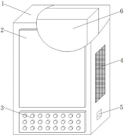
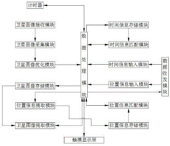
[0018] refer to Figure 1-2 , the present embodiment proposes a device for solving crimes based on satellite positioning analysis, including a housing 1, a display 2 is provided on the housing 1, and an input panel 3 is provided below the display 2, and both sides of the housing 1 are provided with There is a heat dissipation port 4, and a data interface 5 is provided under the heat dissipation port 4, and a main control panel 6 is provided in the housing 1, and a processing circuit, a wireless transceiver circuit, a GPS Beidou positioning circuit and time information are provided on the main control panel 6 The selection circuit, the processing circuit are respectively connected with the wireless transceiver circuit, the GPS Beidou positioning circuit, the time information selection circuit, the display 2, the input panel 3 and the data interface 5, and the wireless transceiver circuit is connected with the monitoring center, and the monitoring center includes a satellite imag...
PUM
 Abstract
Description
Claims
Application Information
 - R&D
- Intellectual Property
- Life Sciences
- Materials
- Tech Scout
- Unparalleled Data Quality
- Higher Quality Content
- 60% Fewer Hallucinations
Browse by: Latest US Patents, China's latest patents, Technical Efficacy Thesaurus, Application Domain, Technology Topic, Popular Technical Reports.
© 2025 PatSnap. All rights reserved.Legal|Privacy policy|Modern Slavery Act Transparency Statement|Sitemap|About US| Contact US: help@patsnap.com


