A traffic control method based on gis

A technology of traffic control and emergency rescue, applied in traffic control systems, traffic control systems of road vehicles, instruments, etc., can solve problems such as casualties, property losses, environmental damage, and troubles for emergency rescue command

Active Publication Date: 2018-05-08
BEIJING UNIVERSITY OF CIVIL ENGINEERING AND ARCHITECTURE
View PDF4 Cites 0 Cited by
  • Summary
  • Abstract
  • Description
  • Claims
  • Application Information

AI Technical Summary

Problems solved by technology

[0007] (3) Emergency rescue vehicles may be distributed in different locations. In the event of an accident, how to coordinate vehicles and implement rescue more efficiently is a problem that has to be considered
[0009] ⑸Emergency rescue operations are very sensitive to time requiremen

Method used


Image

  • A traffic control method based on gis
  • A traffic control method based on gis
  • A traffic control method based on gis

Examples


Embodiment Construction

[0017] In order to make the purpose, technical solutions and advantages of the present invention clearer, the technical solutions in the embodiments of the present invention will be clearly and completely described below. Obviously, the described embodiments are part of the embodiments of the present invention, rather than all of them. example. Based on the embodiments of the present invention, all other embodiments obtained by persons of ordinary skill in the art without creative efforts fall within the protection scope of the present invention.

[0018] Embodiment 1 of the present invention discloses a kind of traffic control method based on GIS, it is characterized in that, comprises the following steps:

[0019] Step 100, obtaining the GIS information of the emergency rescue vehicle;

[0020] Step 200, obtaining the information of the event area requiring emergency rescue;

[0021] Step 300, select an available emergency rescue vehicle;

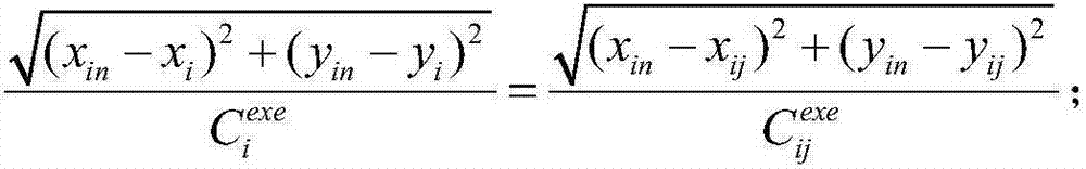
[0022] Step 400, dividing the t...


PUM


Abstract

The invention provides a traffic control method based on GIS. The traffic control method comprises the following steps of: step 100, acquiring the GIS information of emergency rescue vehicles; step 200, acquiring the event area information requiring emergency rescue; step 300, selecting available emergency rescue vehicles; step 400, dividing the task areas of the emergency rescue vehicles; step 500, calculating the rescue path of each emergency rescue vehicle; and step 600, estimating the rescue time of each emergency rescue vehicle, and adjusting the emergency rescue paths according to the estimated rescue time. Emergency rescue tasks can be automatically allocated according to the GIS information of the emergency rescue vehicles and the event area information requiring emergency rescue, so that the emergency rescue efficiency is improved, and the life and property safety of people are guaranteed.

Description

technical field [0001] The invention relates to the field of traffic control, in particular to a GIS-based traffic control method. Background technique [0002] Emergency rescue generally refers to activities and plans for prevention, preparation, response and recovery of sudden and destructive emergencies. According to different types of emergencies, it is divided into emergency rescue in the fields of health emergency, traffic emergency, fire emergency, earthquake emergency, factory emergency, and family emergency. [0003] Geographic Information System (GIS, Geographic Information System) is a comprehensive subject that combines geography and cartography, remote sensing and computer science. It has been widely used in different fields and is used for input, storage, query, analysis and display. The computer system of geographic data, with the development of GIS, is also called "Geographic Information Science" (Geographic Information Science). In recent years, GIS is also...

Claims


Application Information

Patent Timeline
IPC IPC(8): G08G1/00
CPCG08G1/202
Inventor 张学东张健钦庞蕾刘慧王勇刘文茜
Owner BEIJING UNIVERSITY OF CIVIL ENGINEERING AND ARCHITECTURE
Why Eureka
Try Eureka