Flight data three-dimensional visual analysis method and apparatus

An analysis method and analysis device technology, applied in the direction of electronic digital data processing, structured data retrieval, geographic information database, etc., can solve the problems of incomplete display information, no solution proposed, and 2D map display methods are not three-dimensional, etc., to achieve Quickly grasp the effect of flight dynamics

An analysis method and analysis device technology, applied in the direction of electronic digital data processing, structured data retrieval, geographic information database, etc., can solve the problems of incomplete display information, no solution proposed, and 2D map display methods are not three-dimensional, etc., to achieve Quickly grasp the effect of flight dynamics

CN106407263AInactive Publication Date: 2017-02-15天津大海云科技有限公司

Image

  • Flight data three-dimensional visual analysis method and apparatus
  • Flight data three-dimensional visual analysis method and apparatus
  • Flight data three-dimensional visual analysis method and apparatus

Examples


Embodiment 1

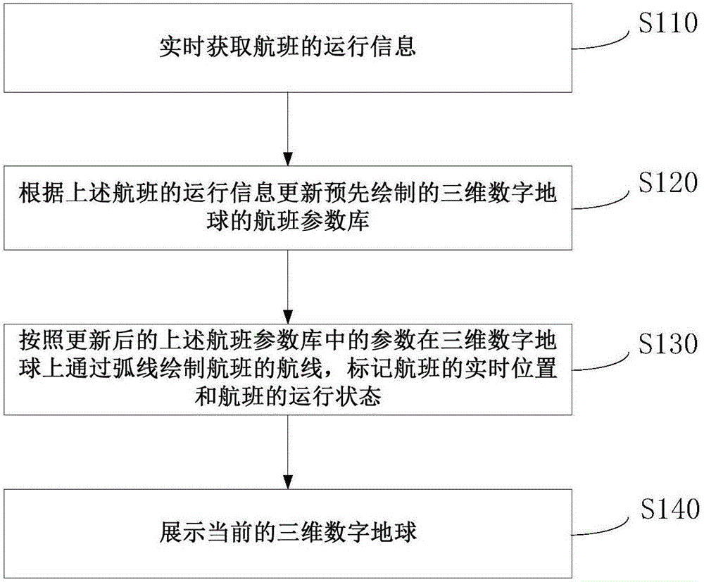
[0049] figure 1 A schematic flow chart of a three-dimensional visual analysis method for flight data provided by an embodiment of the present invention is shown. The following will be figure 1 The specific process of the shown method is described in detail.

[0050] Step S110, acquiring flight operation information in real time.

[0051] The above-mentioned operation information includes the route of the flight, the real-time position of the flight, the operation status of the flight and the flight status information of the flight. The above operation information may be collected from flight databases of airlines or airports. The information collection method is real-time refresh, for example, data extraction is performed at a period of 5s, and the flight status can be grasped in real time.

[0052] Step S120, updating the flight parameter library of the pre-drawn three-dimensional digital globe according to the operation information of the above-mentioned flight.

[0053...

Embodiment 2

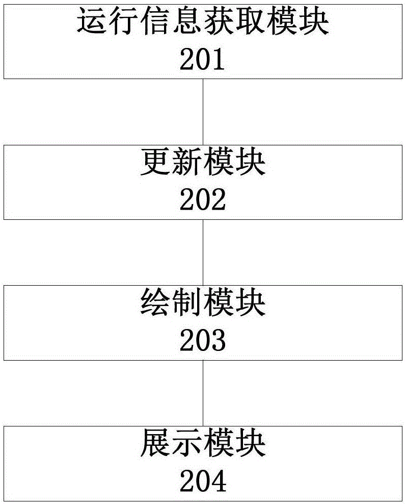
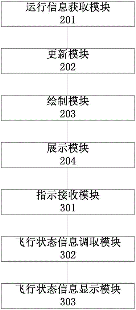
[0072] Corresponding to the methods provided in the above embodiments, the embodiments of the present invention also provide a three-dimensional visual analysis device for flight data, see figure 2 , the device includes the following modules: a running information acquiring module 201 , an updating module 202 , a drawing module 203 and a displaying module 204 .

[0073] The operation information obtaining module 201 is used for obtaining flight operation information in real time.

[0074] The above-mentioned operation information includes the route of the flight, the real-time position of the flight, the operation status of the flight and the flight status information of the flight. The above operation information may be collected from flight databases of airlines or airports. The information collection method is real-time refresh, for example, data extraction is performed at a period of 5s, and the flight status can be grasped in real time.

[0075] The updating module 202...


PUM


Abstract

Embodiments of the invention provide a flight data three-dimensional visual analysis method and apparatus. The method comprises the steps of obtaining running information of a flight in real time, wherein the running information comprises an air route of the flight, a real-time position of the flight, a running state of the flight and flying state information of the flight; updating a flight parameter library of a pre-drawn three-dimensional digital earth according to the running information of the flight; drawing the air route of the flight through an arc line on the three-dimensional digital earth according to parameters in the updated flight parameter library, and marking the real-time position of the flight and the running state of the flight; and displaying the current three-dimensional digital earth. According to the method and the apparatus, the running of the flight on the earth can be subjected to three-dimensional description and display, so that more visual and comprehensive information is provided for users.

Description

technical field [0001] The invention relates to the field of display technology, in particular to a method and device for three-dimensional visual analysis of flight data. Background technique [0002] The way of displaying route data in the prior art is to mark the route on a 2D map, which can only display the path and running time of the route, but cannot display more information about the route and the information of the flights operating on the route. Moreover, since the earth is a spherical structure, the display method of the 2D map cannot clearly and completely display the routes across the edge of the 2D map. At the same time, the display method of the 2D map is not three-dimensional and not intuitive. [0003] For the above-mentioned problems of incomplete and unintuitive information displayed on the 2D route map, no effective solution has been proposed yet. Contents of the invention [0004] In view of this, the object of the present invention is to provide a t...

Claims


Application Information

Patent Timeline
15 Feb 2017
Publication
CN106407263A
IPC
G06F17/30
CPC
G06F16/90328; G06F16/29; G06F16/9038
Inventors
冯一村; 刘成