System and method for generating lane-level navigation map of unmanned vehicle

An unmanned vehicle and navigation map technology, which is applied in the field of the generation system of the lane-level high-precision navigation map of the unmanned vehicle, can solve the problems of limited field of view, insufficient globalization, deviation of the map base map, etc., and achieves wide applicability. , the map data is detailed and rich, and the effect of a wide range of applications

Active Publication Date: 2017-02-22
安徽中科星驰自动驾驶技术有限公司
View PDF7 Cites 186 Cited by
  • Summary
  • Abstract
  • Description
  • Claims
  • Application Information

AI Technical Summary

Problems solved by technology

This method will cause large deviations in the obtained map base map when the road is uneven, and the camera itself is distorted, the field of view is limited, and the overall situation is not good enough.

Method used


Image

  • System and method for generating lane-level navigation map of unmanned vehicle
  • System and method for generating lane-level navigation map of unmanned vehicle
  • System and method for generating lane-level navigation map of unmanned vehicle

Examples


Embodiment Construction

[0037]The present invention will be described in detail below in conjunction with specific embodiments. The following examples will help those skilled in the art to further understand the present invention, but do not limit the present invention in any form. It should be noted that those skilled in the art can make several modifications and improvements without departing from the concept of the present invention. These all belong to the protection scope of the present invention.

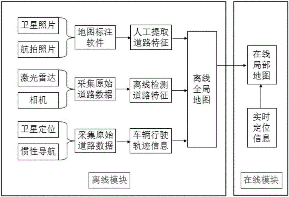
[0038] A system for generating lane-level navigation maps for unmanned vehicles, such as figure 1 shown, including:

[0039] The offline module uses a variety of data collection methods to obtain the original road data in the target area of ​​the unmanned vehicle, and after offline processing, extracts a variety of road information, and then fuses the extracted results to generate an offline global map;

[0040] In the online module, during the automatic driving process of the vehicle in the targe...


PUM


Abstract

The invention relates to a system and method for generating a lane-level navigation map of an unmanned vehicle based on multi-source data. The lane-level navigation map comprises an offline global map part and an online local map part. According to an offline module, within a target region where the unmanned vehicle runs, original road data is acquired through satellite photos (or aerial photos), a vehicle sensor (laser radar and a camera) and a high-precision integrated positioning system (a global positioning system and an inertial navigation system), then the original road data is subjected to offline processing, multiple kinds of road information are extracted, and finally the road information extracting results are fused to generate the offline global map. The offline global map is stored through a layered structure. According to an online module, when the unmanned vehicle automatically drives in the target region, the road data in the offline global map is extracted according to real-time positioning information, and the online local map with the vehicle as the center within the fixed distance range is drawn. The system and method can be applied to fusion sensing, high-precision positioning and intelligent decisions of the unmanned vehicle.

Description

technical field [0001] The invention belongs to the technical field of unmanned vehicles, and in particular relates to a system and method for generating a lane-level high-precision navigation map for unmanned vehicles based on multi-source data. Background technique [0002] At present, the research and development of unmanned vehicles and key technologies is in the ascendant. More and more domestic and foreign automobile manufacturers, IT companies, universities, research institutes, etc. are investing a lot of manpower and material resources to actively promote unmanned vehicles and auxiliary vehicles. R&D and commercialization of driving systems, intelligent connected vehicles, etc. In recent years, Audi, Mercedes-Benz, GM, Ford, Toyota, Nissan, SAIC, Tesla and many other domestic and foreign automakers, as well as technology companies such as Google, have tried to put their driverless vehicles on the market around 2020. [0003] The high-precision electronic map is one...

Claims


Application Information

Patent Timeline
Patent Type & Authority Applications(China)
IPC IPC(8): G01C21/32
CPCG01C21/32
Inventor 王智灵金鹏梁华为崔国才黄俊杰
Owner 安徽中科星驰自动驾驶技术有限公司
Why Eureka
Try Eureka