Flood pre-disaster early warning method based on sequential water scope remote sensing image

A technology of remote sensing images and flood disasters, which is applied to the re-radiation of electromagnetic waves, the use of re-radiation, measurement devices, etc., can solve the problems of poor formation and difficult flood disasters

Inactive Publication Date: 2017-02-22
HUAZHONG AGRI UNIV
View PDF2 Cites 15 Cited by
  • Summary
  • Abstract
  • Description
  • Claims
  • Application Information

AI Technical Summary

Problems solved by technology

Although many scholars are still making unremitting efforts in this regard, there are still great difficulties in establishing pre-disaster monitoring and prediction models and conducting more accurate pre-disaster

Method used


Image

  • Flood pre-disaster early warning method based on sequential water scope remote sensing image
  • Flood pre-disaster early warning method based on sequential water scope remote sensing image
  • Flood pre-disaster early warning method based on sequential water scope remote sensing image

Examples


Embodiment Construction

[0068] The present invention will be further described in detail below in conjunction with the accompanying drawings and specific embodiments.

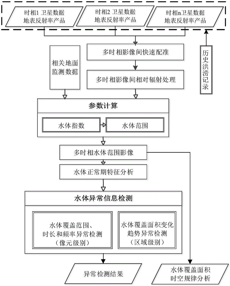
[0069] Such as Figure 1~2 As shown, the pre-flood early warning method based on time-series water range remote sensing images provided by the present invention includes the following steps:

[0070] 1) Input multi-temporal high-resolution surface albedo remote sensing images, combine with historical pre-disaster records, eliminate flood disaster data, and perform data preprocessing on the input remote sensing images through registration and relative radiation correction.

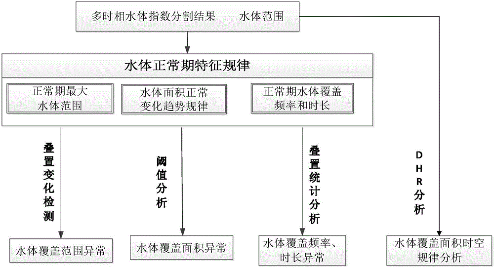
[0071] 2) Calculate the water body index according to the surface reflectance image obtained in step 1), and use the normalized normalized water body index NDWI to extract the water body range, including the following steps:

[0072] A. There are many methods for extracting the range of water bodies. The existing remote sensing image water body extraction methods ...


PUM


Abstract

The invention discloses a flood pre-disaster early warning method based on a sequential water scope remote sensing image. The method comprises the following steps: 1, inputting a multi-temporal high-resolution ground surface reflectivity remote sensing image and performing data preprocessing; 2, calculating a water body exponent, and based on a water body exponent image, extracting a water body scope binary image; 3, extracting water body features of a to-be-detected period and water body features of a normal period; 4, respectively performing stacked comparison analysis on the water body features of the to-be-detected period and the water body features of the normal period to detect abnormity information; and 5, analyzing the tracked detected abnormity information, and if a place which is originally not supposed to be covered by a water body in an observation area is continuously covered by the water body, indicating that the risk of a flood disaster in the observation area is increased and an alarm should be given. According to the method, abnormities of the water body features are analyzed from multiple angles, an early warning of the risk of the flood disaster in the observation area is given according to abnormity analysis, and thus the problem of difficulty in pre-disaster monitoring early warning of the flood disaster is effectively solved.

Description

technical field [0001] The invention relates to the field of flood disaster monitoring, in particular to a pre-flood early warning method based on time-series water range remote sensing images. Background technique [0002] Satellite remote sensing observation technology has been applied to many fields including water conservancy, environmental protection, and disaster prevention and mitigation due to its unique advantages such as wide observation range and periodic revisit. The application of remote sensing technology to monitor flood disasters has become the focus of current research on disaster prevention and mitigation. [0003] At present, the application of remote sensing technology in the field of flood disaster monitoring mainly includes two monitoring methods: spectral remote sensing monitoring and microwave remote sensing monitoring. For spectral remote sensing monitoring, optical remote sensing images have a large amount of spectral information, and it is easy to...

Claims


Application Information

Patent Timeline
IPC IPC(8): G01S17/89G01S7/48
CPCG01S7/4802G01S17/89
Inventor 华丽吴峰云王天巍
Owner HUAZHONG AGRI UNIV
Why Eureka
Try Eureka